Exactly when the decision was made in Cedar City to build a new fort by enclosing part of Plat A with a wall is not known. The fort is not included in Dame’s survey and archaeological evidence shows that the wall encircled only the northeast sector of the plat. Most sources indicate this wall was built in response to the growing Indian unrest which culminated in the Walker War.
By 1853, Mormon settlers had outstayed their welcome in Wakara’s territory. While the Ute leader initially saw the Mormons as a useful barrier between his people and the Shoshoni and as a market for horse trading, the differing perspectives of settlers and Indians led to constant misunderstandings. On their part, Mormons were not sympathetic to Wakara’s raids on weaker tribes, such as the Paiutes, to provide women and children for slave traders. Subsequent antislave-trade acts passed by the territorial legislature displeased the Indians, who felt the newcomers had no right to interfere with tribal economy and traditions. Despite Brigham Young’s policy of conciliation, Mormons were continually on their guard whenever they ventured outside their forts. The Indians feared that, proffers of friendship aside, the coming of white settlers to their homeland meant the end of traditional Indian society.1
In April 1853, a misunderstanding almost triggered armed hostilities in Parowan. George Braffit missed a pair of fine horses after an emigrant party had passed through en route to southern California. A militia detachment, headed by James A. Little and including James H. Martineau, Priddy Meeks, Samuel Gould and nine other men, started out for Iron Springs, the emigrants’ last stop. Wakara and 700 men were camped at Summit Creek and observed this military activity with alarm. A small boy told Wakara’s scout that the militia was “going out to fight Walkar.” When the posse of settlers arrived at Summit Creek, their behavior was so boisterous that Wakara was convinced the information was correct and had his warriors surround the men. When Little explained they were merely after missing horses, Wakara would not believe him and flatly stated the emigrants hadn’t taken the animals.
Colonel Little reportedly said “Well, boys, then let’s go home,” and led his group through the ranks of suspicious Indians, who turned and pursued the settlers rather half-heartedly for some time. The militia reached Parowan safely but a council was quickly convened and “everyone went to making bullets.” A young man named Samuel Lewis volunteered to report this encounter to Brigham Young and ask his advice. Leaving the settlement within the hour, he successfully made the 540-mile round trip in eight days, averaging over 65 miles a day. He returned with “orders to avoid all trouble or conflict, as Parowan was too distant to receive any help.” Fortunately, by the time he returned, local tensions had subsided.2
Brigham Young was very aware of such dangers, especially to those in outlying colonies. He took advantage of the 4th of July 1853 falling on a Sabbath to reaffirm previous counsel. The content of his Sunday sermon from the Tabernacle to the members at large could not have reached southern Utah for several days at least. Its context, however, shows that initial warnings to prepare against possible Indian attack had been made some weeks before he spoke:
There seems to be some excitement among the people, and fears are arising in the breasts of many as to the general safety. . . . If the people of Utah Territory would do as they are told, they would always be safe. . . . The word has gone out now, to the different settlements in the time of harvest, requiring them to build Forts. Could it not have been done last winter, better than now? Yes. Do you not suppose people will now wish they had built Forts when they were told? . . . They will learn better I expect by and by, for the people have never received such strict orders as they have got now. I will give you the pith of the last orders issued; (v.z.) “That man or family who will not do as they are told on the orders, are to be treated as strangers, yea, even as enemies, and not as friends.”3
The same month, Indians and Mormons fought at Springville, Utah County, over how much fish should be traded for how much flour. The minor affair escalated, not ending until violence broke out, leaving one of the Indians dead. Efforts at some form of conciliation on both sides were of momentary effect and on 18 July 1853, Wakara’s brother Arapeen (or Arapeen’s companion) fatally shot Alexander Keele as Keele stood guard at Fort Peteetneet.4 In response, Colonel Peter W. Conover, acting on Brigham Young’s orders, left Provo on 19 July, heading for Manti with 150 men, intending to help weaker settlements along the route by displaying strength and resolve to Wakara. But the Indians were “neither idle nor dismayed by the force sent out.” In a set of well-directed, simultaneous skirmishes, they surprised the post at Pleasant Creek, stole cattle from Manti and horses from Nephi and wounded a guard in Springville.5
On 20 July, Apostle Franklin D. Richards arrived in Parowan to inform the settlers that general fighting had commenced and that they were to take immediate precautions. As governor and ex officio superintendent of Indian affairs, Brigham Young issued General Orders on 21 and 25 July, outlining military measures. An 1852 restructuring of the Nauvoo Legion by the territorial legislature had elevated Daniel H. Wells to the rank of lieutenant general, the first to be given that position since Joseph Smith. Young and Wells now ordered that
the policy of constructing forts and occupying them be adopted and rigidly enforced—that the commandants of the various military districts in the Territory cause all of the forces under their commands respectively to repair immediately to their posts in their various settlements putting the same in a state of effecient defence, keeping their arms and ammunition in readiness, constructing corrals for stock and stack yards for the grain and taking all possible care of the grain, hay and vegetables.6
Apparently believing that Conover had become more punitive of the Indians than protective of the settlers, Brigham Young also ordered a conclusion to his military expedition and forbade “the settlers to retaliate on the Indians or threaten retaliation.” In Conover’s place, Brigham Young sent his southern Utah specialist, George A. Smith, to take “command of all the Military districts south of Great Salt Lake County, with instructions to enforce General orders No. 1.”7
Abandoning the Compact Fort, 27 July–11 August 1853
Meanwhile, events in southern Utah were taking on the form and direction Brigham wished. On 26 July, the very day after the second issuance of General Orders in Salt Lake City, George Bowering noted in his journal that, as part of a continuing celebration in Cedar City of the festivities surrounding the 24th, a dance was held in the afternoon.
. . . in the midst of dancing in all the glory thereof. We were called out of the Ball-room in the Bowery to listen to instructions, or orders, from Head Quarters, that is to say from Pres. Brigham Young, Governor of Utah Territory. The orders were to enforce Martial Law, in consequence of Indian difficulties. And notice given for every man to reassemble in the Bowery to-morrow morning to hear the General Orders read[.]8
Bowering had only been in the Cedar City settlement since 30 April 1853, arriving that Saturday evening with his fellow-travelers, the Robert Latham family. He expected to be employed herding cattle but was quickly called to teach school instead. Since he boarded successively with parents of his students, he did not at first build a home of his own. Starting classes at 9 a.m. on Monday, 9 May, with nearly 60 pupils, he probably spent much of his time in the Compact Fort in the “Small log-house called the schoolhouse.” His description might have mildly irked Henry Lunt, who had just overseen a “comodius” enlargement of the building, completed, almost certainly, in the hours just prior to Bowering’s arrival.9
On 27 July, the morning after the dance was interrupted, the men gathered in the Bowery to hear the reading of General Orders, after which the battalion was reorganized. Instructions from Salt Lake City were very clear and, as Bowering reports, were carried out right away:
The families living South side the creek commanded to move into the fort. Peter Shirts came in from Shirts’ Creek seven miles south. John D Lee came in from Harmony sixteen miles south. The brethren began to build up every open place in the fort, and to settle down as well as they could, Joel H Johnson and family moved in from his place six miles north, The brethren stood guard day and night and things going on well under the directions of Elder F D Richards[.]10
Twenty-six teams and wagons were immediately dispatched to help dismantle Harmony’s eight houses, load up the logs and transfer them to Cedar City. Twelve teams came from Cedar City to Shirts Creek and 20 to Johnson’s Spring to help with the move.11
Brigham Young sent Lieutenant Colonel William H. Kimball, son of his counselor Heber C. Kimball, to implement General Orders in the outlying colonies during this period of uncertainty. Kimball, whose “Southern Expedition No. 1” raised the protective mine breastworks mentioned in chapter 9, kept a daily journal of their itinerary. On 2 August, Kimball rode into Parowan, noting on the same day that “E. F. Heap,” Superintendent of Indian Affairs (actually E. F. Beale) made him a courtesy call.12
On the 3d, Kimball assessed Parowan’s military status, pronouncing all but two of the settlement’s firearms in good condition. He praised the town, saying the pioneers were “in good order for defending themselves,” and singled out Captain Hopkins for “having his men under a rigid discipline.” Returning to Cedar City, Kimball and his party passed through Johnson’s Spring, confirming that the small colony had indeed relocated to the larger settlement.13 “The Piede [Paiute] Indians at these settlements were very friendly,” reported John Lyman Smith who had joined Kimball’s expedition. “[T]he settlers left their grain; chickens, &c., in their care.”14
These reports are complemented by those of E. F. Beale, Kimball’s misidentified visitor. Traveling through Cedar City with a small party on 4 August 1853, he recorded the scene in the official journal of the trip:
The inhabitants are principally foreigners, and mostly Englishmen from the coal districts of Great Britain. At the time of our visit, the place was crowded with the people of the surrounding country seeking refuge from the Indians, and its square was blocked up with wagons, furniture, tents, farming implements, &c., in the midst of which were men, women, and children, together with every description of cattle, creating a scene of confusion difficult to describe.15
We know that the fort referred to directly by Bowering and indirectly by Beale is the Compact Fort, because construction of defensive walls in Plat A had not yet begun. Bowering, in fact, provides the information we need to distinguish between the two sites. On 4 August, he records the arrival of George A. Smith, eager to implement the intended “measures for their safety.” Between 9 and 12 August, Bowering documents the resulting changes:
Aug: 9th Monday. . . . Notice given that the fort be vacated on Wednesday next, that the inhabitants move over to the south side of the creek upon the Plat Appointed for a City and there build a fort half a mile square and when the inhabitants sufficiently strong the fort to be enlarged south and west.
Aug: 11th Wednesday. Early this morning a general pulling down and moving all useable materials and goods unto the New Fort, Soon every house were down.
In retrospect, it may seem the leadership was being inefficient in its arbitrary shuffling of people and resources back and forth during the crisis. First, on 27 July, everyone in Cedar City and the outlying colonies was told to move to the Compact Fort, in effect abandoning Plat A, which until that moment had been not only the preferred but the official place of settlement since the authorized relocation several months earlier. Then, only two weeks after the settlers responded by crowding into the Compact Fort, they were told to move back to Plat A and not merely abandon the Compact Fort temporarily but demolish it completely and fort up on Plat A as quickly as possible.
On reflection, however, we can identify the sound logic dictating these unusual population shifts. If the risk of hostile attack were believed to be immediate and intense, it would make sense to bring everyone into the Compact Fort where people could be assigned front-line and support roles quickly and easily if the dangers escalated. Once the imminent threat subsided, however, the Compact Fort’s vulnerability to Indian attackers using the Knoll to their advantage would be weighed and a quick remove to a less vulnerable position authorized. This could easily account for the short time the settlers spent in the Compact Fort and the speed and certainty with which they were ordered to move back to (and only to) Plat A. The demolition of the Compact Fort would seem to be a confirmation of this thinking, as the leaders would not have allowed any large building components (however disassembled) to remain behind, providing Native American raiding parties with inadvertent cover.
Evacuating to Parowan
While Cedar City was taking in evacuees from Shirts Creek, Fort Harmony and Johnson Springs, Parowan was hosting settlers from Paragonah. George A. Smith ordered the evacuation of Paragonah’s citizens on 3 August 1853. Paragonah means “many springs”or“marshes” in the Paiute tongue. It was originally farmland claimed in 1851 by brothers Job and Charles Hall of Parowan. In 1852, a company led by William H. Dame built rude huts to provide shelter while they began farming; the crop was so successful that many men brought their families and settled permanently.17
Although George A. Smith’s orders did not call for Paragonah to be razed, it was evidently destroyed as one of the protective measures triggered by the Walker War. On 2 August 1853, two days before E. F. Beale noted the vivid confusions of life in the temporarily crowded Compact Fort, he passed through Paragonah just in time to see it dismantled. As he described it, the town had
about thirty houses, which, although built of adobes, present a neat and comfortable appearance. The adobes are small and well pressed, and, are made of a pink-colored clay. The houses are built to form a quadrangle, the spaces between them being protected by a strong stockade of pine pickets. Outside of the village is an area of fifty acres inclosed within a single fence and cultivated in common by the inhabitants. It is called The Field, and a stream from the Wahsatch Mountains irrigates it, after supplying the town with water. . . .
We did not remain long at Paragoonah; for soon after our arrival, the inhabitants, in obedience to a mandate from Governor Brigham Young, commenced removing to the town of Parawan, four miles to the southward, as he considered it unsafe, with the smallness of their number for them to remain at Paragoona. It was to us a strange sight to witness the alacrity with which these people obeyed an order which compelled them to destroy in an instant, the fruits of two years’ labor; and no time was lost in commencing the work of destruction.18 Their houses were demolished, the doors, windows, and all portable wood-work being reserved for future dwellings; and wagons were soon on the road to Parawan, loaded with their furniture and other property.19
Parowan was undergoing changes of its own, if less drastic ones. It is not clear how complete its fort was in the first days of August 1853. We can, in some ways, think of Parowan as “between forts.” The original lots surrounding the public square of old Fort Louisa had just been expanded, requiring removal of the pickets that had helped form a complete outer wall. Houses built around the perimeter had been moved to the fronts of their lots. With the influx of settlers from Paragonah, the population would have been near 400. Almost certainly, George A. Smith urged the citizens in August 1853 to make a fort (or at least repair the existing wall), but they seem initially to have relied instead on the strength of their individual houses and their military preparations.
Feuding over the Cattle
While the outlying settlers were being evacuated to the larger townsites, loose stock, according to General Orders, were to be sent to Salt Lake City for protection. George A. Smith rounded up 271 head of cattle and four horses as this “surplus stock,” in an effort to comply.20 The action was taken to deny Indian raiding parties their spoils of war, as well as to protect the pioneers’ major investment in the livestock so crucial to their survival. Smith, however, met strong opposition at Cedar City from settlers who refused to send their herds along with the rest. George Bowering’s journal entry lends a touch of understatement to a volatile situation:
Aug: 8th Sunday. This morning. The County Commander, Colonel James A Little, Bp P. K Smith and others seperated the cattle to be in readiness to move the surplus. I was told some were opposed unto their cattle going, brought out their Guns, threatened to shoot the man who would touch their cattle. This caused the buisness to be deferred for the present.21
Matthew Carruthers, head of the Cedar City militia, chose to resign his commission rather than comply with the order and was replaced by John D. Lee. George A. Smith immediately delegated to Colonel William Kimball the task of persuading the settlers to obey counsel and release the cattle forthwith.22
The cattle owners, however, were not ready to be convinced. Their unexpected display of stubborn disobedience brought a flurry of consequences, including meetings to consider the “improper conduct” of the miscreants and a sermon from the equally adamant George A. Smith, speaking “against rebelling and showing the duties of saints.” On 9 August, Richard Varley was held “Under trial and aquited,” but Joseph Hunter Sr., George Hunter, John Gregory, William Addshead and David Stoddard were found guilty and “put under guard for their rebellion yesterday.”23 Since all this occurred at the very moment of removal to the “New Fort,” that goal took precedence. The men remained under arrest until Sunday, the 15th, when, as Bowering noted,
Elders Geo A Smith and F D Richard[s] held a council with the Authorities[.] At 3 o’clock p m A meeting held out of doors near the house of Elder James A Little. Pres: Henry Lunt and others addressed the congregation on redeeming ourselves from all disgrace that is upon us respecting the cattle. On Motion that we send more cattle away. Carried. On motion that Bp P K Smith and Elder J D Lee be the judges to say what cattle go away and what remain Carried. On motion a Petition be sent to Parowan to redeem our brethren who are prisoners which have gone away Carried.24
According to local tradition, the livestock were never returned, even after peace was restored. If true, this was probably not due to intentional misappropriation or neglect. Communal herds faced dangers other than Indian attack. Livestock in Manti, for example, were decimated by wolves and coyotes. Church-owned cattle herds in Cache Valley suffered losses of almost 80 percent during the severe winter of 1855–56.25 Even so, the social fabric of Cedar City was certainly weakened by this event. Bowering records attending a meeting on 8 October that, although cattle are never mentioned, must have been a reaction to moving the herd:
As several of the brethren are dissatisfied with things and the government of affairs in the presiding Officers being tyranical in their rule: they are preparing to go to California and occasionally meet together to arrange their buisness. As I was lodging with Richard Varley and the meeting to night was at his house I took the liberty to remain and stay the meeting. They did not say any thing against the principles of the gospel only against the tyranical rule the Officer took and they could not stand it. Was preparing to arm themselves with weapons of defense. If they were followed by the Officers to try to bring them back they would try the virtue of bows and arrows, that they would not be brought back alive.
This is followed by two brief entries reading “Oct 16th Monday. Some of our California brethren started out to day,” and “Oct 17th Teusday. The remainder went to day.”26 By mid-November, ecclesiastical leaders in Cedar City took action against a total of 26 people who had left the settlement in recent weeks for the West Coast, excommunicating all of them and court-martialling seven for “breaches of discipline during the Walker War.”27
Forting Up the Plat A Site, 11 August 1853–5 January 1854
Elias Morris, a brick mason who reached Cedar City on 30 April 1853, the same day George Bowering arrived, penned a journal entry covering the whole relocation phase, up to and including the construction of a fort wall:
At this time [the settlement] was a small log cabin fort on the north side of the river. . . . I commenced to build a house inside the fort, had the walls up to eight feet hiegh. . . . Before I could complete my house, an Indian war broke out, and martial law was declared. By order of G. A. Smith who was the commander in chief of the Southern district, we torn down the old fort and moved to the south side of the river where a city was surveyed, half a mile square. In one week all the inhabitants was transferred from the old fort into temporary shantees and dug outs. The first public duty we had to do besides standing guard night and day under military orders was to build a fort wall of adobe ⅓ of a mile square and 8 feet high which was done in a very short time.28
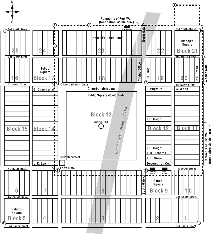
The siting of the fort at the northeast corner of Plat A proper is clearly shown on illustration 12-1, the Plat A Fort Layout. Reasons for enclosing only that part of the townsite are sound: (1) the northeast sector was closest to the waters of Coal Creek; (2) that sector was also closest to the Compact Fort survey site and to the iron works; (3) the land was better there, due to rich silt deposits from Coal Creek. According to pioneer property records, 54 of the Plat A city lots claimed by settlers were completely inside the area circumscribed by the wall. Another 16 were either next to or part of the wall on the west and south sides, while 20 were completely outside the wall.
Illus. 12-1. Plat A Fort Layout: this diagram shows (1) fort layout including community squares and gates; (2) representative house lots; (3) block numbers (in gray); (4) brass caps marking fort wall perimeter (in octagonals).
Heeding Brigham Young’s counsel and complying with local leaders produced not merely a rush of activity but tangible results on and around Plat A. In a letter of 25 September to Franklin D. Richards, printed in the Deseret News, Henry Lunt reported the rewards of obedience:
The General orders of the Governor are being carried out daily. The amount of labor that has been done since our removal from the old fort, seems to surpass all I ever before saw. There is an immense quantity of hay stacked within our fort. We are now nearly every man engaged in enclosing the fort, principally with an adobie wall, and hope to have it finished soon. We have six men with the herd of cattle daily, well armed, and a strong guard every night around the fort; and as soon as the fort is enclosed, hope to commence the iron work anew.29
A month later the settlers were shocked to learn that Pahvant Paiute Indians had killed U.S. Army Captain John W. Gunnison and seven of his company on the Sevier River. Surveying a railroad route, Gunnison had been in the wrong place at the wrong time when the Indians attacked to avenge the murder of a chief’s father by a passing immigrant train.30 Perhaps motivated by this news, Apostles Erastus Snow and Franklin D. Richards decided in November to found a new settlement at Summit Creek, seven miles west of Parowan, to afford the remaining cattle better protection. Even during this period of uneasiness, however, Mormon attitudes toward the Indians were not entirely defensive. The preceding September, as Andrew Jenson noted, “Elder Joel H. Johnson was appointed to teach the Indians farming and other work, and to teach the Gospel to them; all his children to do the same forever after him.”31
Meanwhile, despite the progress made, construction of the Plat A wall was so slow that by 18 December Bishop Klingensmith asked the settlers to postpone Christmas festivities until the wall was up and the gate hung.32 By 29 December, Henry Lunt wrote the Deseret News that the iron works had “stopped for the last few weeks to enclose the Fort.”33
Early in 1854, John D. Lee wrote Brigham Young that “On the Sunday before Christmas, the people voted to enclose the city with walls, bars and gates before they should dance and make merry, and from that time on, a general rush was made until the gates were up—which was completed on 5th January.”34 Lee’s letter implies a unity more hoped for than true. According to William Palmer, the young people argued that they had worked hard and deserved a Christmas Eve dance. Bishop Klingensmith refused permission, however, citing the promise everyone had made to forego celebrations until the wall was done.
The would-be dancers next pled their case with Thomas Cartwright, the town fiddler, who yielded and had them move the furniture out of his house to provide room for dancing, but the bishop’s sharp ear heard the fiddle. He immediately “bore down upon the revelers, broke up the party, and on the spot cut them all, Brother Cartwright and the caller included, off the Church for breaking their covenants.” Cartwright quickly appealed to the high council, who deliberated but could not agree amongst themselves. Stake President J. C. L. Smith had the councilmen join in a prayer circle and then adjourned the meeting, telling them to take one hour and come back prepared to vote. At that point, “a spirit of unity and peace came upon them” and the problem was resolved. Memberships were restored, the hand of fellowship extended to all and everyone agreed to be back on the job the next morning, where they worked diligently until the task was done.35
The well-earned sense of accomplishment felt by all at finishing the Plat A fort wall, however, was of short duration. Constructed in haste, some sections of the wall proved weak. On 20 January, as John D. Lee wrote President Young four days later, “a wind storm from the S. W. blew down from 15 to 20 rods of our fort wall, on the N. and S. lines. The storm lasted 24 hours; it was the heaviest wind storm that I ever saw in the mountains.”36 Samuel H. Rogers, newly arrived in Parowan from Utah Valley, was among those recruited to rebuild the wall. On 27 January 1854, he records that he “toock my family to Cedar City, Built my portion of city wall” and then returned almost immediately to Parowan, at the request of the stake president, to help move a newly established cattle herd to the Summit Creek sanctuary.37
Even though the push to secure the settlements had depleted their resources, the Mormon settlers were willing to share what they had with a party of explorers who appeared unexpectedly. A Parowan lookout had reported seeing Indians on 6 February, coming from the north about 20 miles away. These travelers proved to be John C. Frémont with nine fellow explorers and 12 Delaware Indians who reached the fort the next day “in a state of starvation.” Captain Frémont had attempted to cross the same mountain range which had proved so difficult for Parley P. Pratt’s Southern Exploring Expedition four winters earlier and had fared much worse:
One of [Frémont’s] men had fallen dead from his horse the day previous . . . They reported that they had eaten twenty-seven broken-down animals; that when a horse or mule could go no farther, it was killed and divided out, giving one-half to the Delawares, and the other to the Colonel and his men; the hide was cut in pieces and cast lots for. After the bones had been made into soup, they were burned, and carried along by the men for luncheon. The entrails were shaken, and then made into soup, together with the feet and eyes; thus using up the whole mule. They stated they had travelled forty-five days living on this kind of fair.38
Frémont himself wrote to his wife, “We owe our lives to these good Mormons, who not only cared for us for two weeks, but gave us food and new horses to continue our journey.”39
Features of Cedar City’s Plat A Fort
William Chandless, whom Gustive Larson calls “Cedar City’s first tourist booster,” visited Cedar City during this period and was impressed by the finished fort. He described it as:
a square of half a mile with almost continuous houses on each side and the hinder wall of these forms the fortifications of the place. The center of the enclosure is used as a farm-yard ground, corrals for cattle, etc., so that the place is very open and with a delightful airiness.40
There are differing accounts of the dimensions of the wall itself. Solomon N. Carvalho, traveling with Frémont’s party as an artist, described the structure as “an adobe wall twelve feet high, six feet at the base to two and a half at the top.”41
According to the Charles Willden family history, “The walls of the new fort were to be of adobe, 10 feet high, three feet thick on the stone foundation and taper to one foot thick on the top.”42 Lunt had also reported the walls of his adobe house to be 10 feet high.43 Andrew Jenson claimed the walls were “8 feet high, built of adobes and washed gravel, cut into chunks.”44 Perhaps wall height varied or perhaps some of the witnesses reported estimations rather than actual measurements.
Illustration 12-1, the Plat A Fort Layout, is derived from three maps, showing the boundary of the wall and features of the fort inside Plat A’s perimeter. The component maps are: (1) the Plat A Map with engineering overlay, created by York Jones in 1984 in collaboration with Morris Shirts; (2) William Palmer’s drawing of the Plat A Fort, published March 1951 in the Improvement Era; and (3) Andrew Jenson’s “1853 Plan of Cedar Fort” in his “Manuscript History of Cedar City,” compiled around 1910. He almost certainly based his illustration on Palmer’s early interview and research notes, adding a few more details to Palmer’s drawings.45 Both Palmer and Jenson describe the Plat A Fort as being around 100 rods square, very close to the dimensions given by Elias Morris: a walled fort one-third-mile-square (1,760 feet or 106.6 rods). The actual space enclosed by the fort wall (see perimeter marked on illus. 12-1) is closer to 115 rods square.
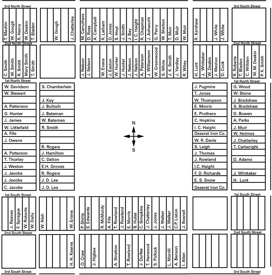
By correlating illustration 12-1, the Plat A Fort Layout, with illustration 11-1, Dame’s 1852 Plat A Survey, and then factoring in data from the Iron County Recorder’s Office, we can begin to grasp the layout of the entire settlement, identifying specific lot owners and related community sites. To make this correlation, we need a fixed point. In his journal, Henry Lunt names the location of his house on the new city Plat As Lot 5, Block 19 (confirmed by deed of 3 March 1853 in the Iron County Recorder’s Office).46 Dame places this lot on the west edge of Block 19, adjacent to the northeast corner of the public square. Combined, Lunt’s deed and Dame’s survey provide the required fixed point, allowing us to identify the owners of the other lots in Plat A. These can be found on illustration 12-2, Plat A Lot Owners.
On 30 January 1860 the boundaries of the Cedar City Ward were redrawn as follows:
First Ward: east line and Center of Old Fort Second Ward: south and west line of Old Fort Third Ward: two blocks east of New City Fourth Ward: remaining part of New City
These new boundaries demonstrate that, even this long after the Compact Fort or “Old Fort” was torn down, people were still living on its site, as well as on the “New City” or Plat A site.47 Collating the various descriptions of and comments about Cedar City’s early years leads to several tentative but logical conclusions regarding the development of the growing township.
For instance, three of the gates into the fort seem to be named for adjacent property owners. Wood’s Gate, on the east side, is just north of George Wood’s lot; Chamberlain’s Gate, on the west, is just north of Solomon Chamberlain’s property; Lee’s Gate, on the southwest, is just south of John D. Lee’s two lots. Those responsible for erecting the Daughters of Utah Pioneers monument must have known where to place it, as the inscription correctly marks the southeast corner of Block 14 as being the John D. Lee Gate, which was sited at the southwest corner of the public square (see illus. 12-1), the intersection of then-First South and First West.
A second point is that some houses not placed on deeded lots seem to have been built inside the north wall where their foundations can still be seen, but no clear references to these houses have yet been found in writings of the period or in the deed books. Palmer’s Improvement Era drawing identifies one house as belonging to John M. Higbee, an immigrant who arrived from Utah Valley in the fall of 1853 and who may have built a temporary shelter or even a cabin against the north wall, facing the seven-rod wide street (see illus. 12-1).
The location and ownership of individual lots help us identify the position of the wall relative to the rest of the settlement. Correlating the claimed lots before and after martial law was declared shows that, prior to August 1853, 11 lots were outside the wall, 30 were inside and three were along the wall; after martial law was declared, nine were outside the wall, 24 inside and 13 along the wall. The number of lots along the wall of the fort increased significantly once the likelihood of Indian attack seemed eminent.
No record of owners exists in the Iron County Recorder’s Office for lots in the southeast corner of the plat, Blocks 1, 2 and 10 (see illus. 12-1 and 12-2). Almost half of the lots in the southwest corner of the plat were likewise unclaimed (Blocks 4, 6 and 7), possibly because they were difficult to irrigate (not currently the case) or perhaps because they were close to Indian campgrounds or major trails.
Illus. 12-2. Plat A Lot Owners: William Dame’s 1852 Plat A Survey showing individual Cedar City lots, with names of owners superimposed, taken from deed books of the Iron County Recorder’s Office. See app. 8.
The south and west portions of the wall were unusually placed, because they bisected all the lots surveyed along those sides, as the broken line on illustration 12-1 shows, marking the layout of the Plat A fort wall. Had a fort wall been factored into Dame’s original October 1852 survey, he would logically have designed it around the entire perimeter of the city lots or down internal streets or alleys. An experienced surveyor, he would not have run sections of wall straight through blocks reserved for schoolhouses, let alone through the home lots of individual settlers.
Two Cedar City ordinances passed in 1855 suggest that the fort wall was fairly flimsy in parts because people were piercing it, possibly to gain access to corrals and gardens on the west and south. The wording suggests that the upkeep of the wall was prorated among the settlers, each family held responsible for a certain section. The first ordinance, approved 7 April 1855, reads: “Be it ordained by the City Council of Cedar City that any Person or Persons refusing or neglecting to put up their Wall when called upon by the overseer shall be liable to a Fine of Fifty Dollars and the expense of building the Wall before any Court having Jurisdiction.” The second ordinance, passed barely two months later, reads:
Sec. 1. Be it ordained by the City Council of Cedar City that any Person or Persons, who have wooden Pickets in their Portion of Wall shall remove them forthwith and replace them with adobies, where the situation of the place will admit, to the acceptance of the overseer of the Wall.
Sec. 2. No Person or Persons shall cut or make any Hole or Door way through the Wall of this Fort, without making a Door or Shutter Bullet proof and that with the advice and consent of the overseer.
Sec. 3. Any Person having Portions of Wall, that require Propping, shall remove the Props and build the Wall to stand without them, to the acceptance of the overseer.
Sec. 4. Any person refusing or neglecting to comply with this ordinance shall be liable to a Fine not to exceed Fifty Dollars at the discretion of any Court having jurisdiction.48
These ordinances clearly imply that the wall was neither cut stone nor neatly mortared brick. Some parts had a rock foundation but the major building material seems to have been adobe brick, supplemented by mud, straw and 4 by 10 inch blocks of silt and gravel, initially deposited as sediment in the flood plain of Coal Creek. Other sections were makeshifts of stick, brush and willow that frequently had to be propped up.
Modern Remnants of Plat A Landmarks
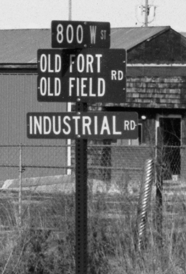
Early deeds and surveys reveal how pioneer Plat A relates to modern Cedar City. The public square, or Block 13, provides an excellent example. The street plotted along the south side of Block 13 aligns well with modern roadways known today as “Pioneer Road” or “Industrial Road” (note the signposts labeled “Old Fort Rd.” and “Old Field Rd.” above “Industrial Rd.” in illus. 12-3). The west side of the street running along the west edge of Block 13 coincides with a modern fence line, while the east side of the street on the east side of the public square lines up with modern commercial property.
Illus. 12-3. Convergence of streets at 800 West preserves the pioneer connection to modern Cedar City. Photograph by Morris A. Shirts.
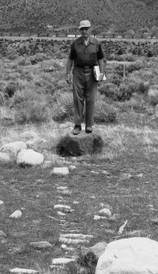
Remaining physical evidence confirms that the old fort wall followed the outer perimeter streets on the north and east sides of Plat A. The north side of the north perimeter street coincides today with what is believed to be rubble from the wall that was built there around 1853–54; a section of wall foundation is still visible (see illus. 12–4). Further, a wall foundation was unexpectedly discovered north of the bishop’s square, Block 21 (see illus. 12-1), suggesting the wall was extended there beyond the town’s original boundary. What may very well be rocks of the east wall of the fort can also be seen for about 30 feet near the north end of the east boundary line. Limited excavation in selected spots on the north side has also revealed remnants of a foundation.
Illus. 12-4. Remnants of a rock foundation of the Plat A fort wall, visible along the north side of the north perimeter street. Photograph by Morris A. Shirts.
The south side of the south perimeter street on Plat A lines up roughly with the location of modern Cedar City’s 400 North (originally 300 South). With reference to the bisected lots, the wall ran completely down Blocks 24, 17 and 14 on the west. It formed the southwest corner of the fort by clipping the north end of Lot 1, Block 7, thence running across all lots in Blocks 8, 9 and 10 before turning to become the east side of the wall. The irrigation ditch, dug to bring water to the pioneer garden plots, aligns extremely well with the west side of the west perimeter street on Dame’s Plat A map. Note the sites of the 13 brass caps marked on illustration 12-1. These caps mark the entire perimeter of the fort wall. The photograph of Morris Shirts and York Jones (see illus. 12-5) documents the placing of Brass Cap No. 7, which marks Henry Lunt’s Lot 5 on Block 19.
Illus. 12-5. Author Morris Shirts (left) and colleague York Jones place Brass Cap No. 7 on the site of Henry Lunt’s Lot 5, Block 19. Photograph provided by Morris A. Shirts.
Forting Up in Parowan
As mentioned earlier, Parowan citizens did not completely enclose their town in 1853, despite continuing tensions with the Indians. After several attempts at reconciliation, Brigham Young and Chief Wakara finally concluded a peace treaty on 11 May 1854 at Chicken Creek. On 24 May, Brigham Young visited Parowan accompanied by Wakara, Squash Head and another Indian dignitary named Grosepeen. At least part of the purpose of this joint tour was to graphically demonstrate the end of hostilities, for Young, in a public meeting at which he announced that the war was over, pointed to Wakara and said, “I have the war with me.” Nevertheless, he then directed the residents of Parowan to fort up, as the citizens of Cedar City had done. The directive was to surround the city by a wall 12 feet high and six feet thick.49 Even though it was planting season, the settlers dutifully complied. By 15 July, Martineau reported to the Deseret News that “Our wall is very rapidly progressing, considering the enormous weight of labor resting upon our shoulders.”50 He later referred to the wall as “ built at a cost of many thousands of dollars.”51
Although tensions had eased, the colonists must have wondered whether the peace would hold. On Friday, 22 September, an Indian stole a horse from Beason Lewis of Parowan. The thief was soon apprehended. He was held under guard in the schoolhouse while the settlers debated whether to take any action. Members of his tribe, assuming he would be executed, set up ambushes all around the city and planned a general massacre but the Mormons released the man with a stern warning, perhaps not realizing at the time how close they had come to disaster. Four days later, George A. Smith returned from Salt Lake City. He found the Indians insolent and demanding tribute from the settlers. It was unanimously decided to stop all work except grain harvesting and finish the Parowan wall to its full height of 12 feet. According to Martineau, this was an enormous task, “but the people worked with a will, knowing that it would add greatly to their safety. The wall was of dampened earth and straw solidly compacted, and became in time as solid as an adobe.”52
On 7 November, John Steele reported to George A. Smith that the wall completely encircled the city, although it was not uniform in height: “some of it is five feet high, some ten; and about one half is up twelve feet, the full height. It is six feet wide at the bottom, and two feet and a half at the top.”53 Andrew Jenson gives the only known statistics on the length of the wall, stating that it encircled the old fort “which was 56 rods square, with a wall enclosing 112 rods square.” His remaining dimensions are identical to Steele’s.54
On 29 January 1855, only eight months after negotiating peace with Brigham Young, Chief Wakara died at Meadow, just south of Fillmore. David Lewis had visited Wakara only the day before to deliver a letter from Brigham Young, expressing his continued support. Parowan settlers were advised to stay inside the fort until after the funeral ceremonies, since it was feared the Indians might want to provide Mormon “attendants” to escort their chief to the land of the dead.55 Instead, a Paiute slave girl, two women of the tribe and between 12 and 20 of Wakara’s best horses were killed. A young Paiute boy was tied to Wakara’s body alive and buried with the chief. In addition to these sacrifices, which were apparently contrary to Wakara’s dying wish, he was buried with guns, bows and arrows, blankets, buckskin robes, cooking utensils and the unopened letter from Brigham Young.56 According to tradition the grave was located high on Pig Mountain east of Meadow Creek near the “eye” of the “old sow,” a local landmark.57
Modern Remnants of Parowan Landmarks
The exact location of the fort wall built by Parowan’s settlers in 1854 is uncertain. However, Ray Morris and Frank Mortensen, both descendants of Parowan settlers and both in their eighties when interviewed in 1982, agreed in general that it ran along the north line of the Karl Morris property at 51 North 300 West. Mortensen recalled that a waterwheel, installed at the northwest corner of the fort, had left an indentation and that, during his lifetime, earth from the old wall was scraped into the depression.
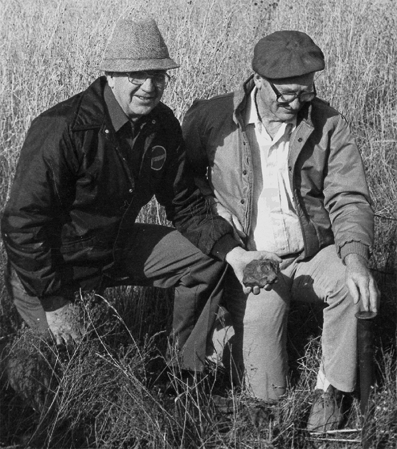
Mortensen stated in 1982 that the south wall ran along the south side of 200 South and that a now-demolished building at 50 West 200 South, used first as Calvin Pendleton’s gun repair shop and then as a Presbyterian school, stood just inside the fort wall. Mortensen recalled that William Thornton formed an ad hoc committee of older citizens in the 1950s. Based on their memory of the wall’s location, they supervised the installation of three-inch steel posts about three feet high to mark the fort’s four corners. Two are still in place. The northwest corner marker is near 70 North 200 West, on the east side of the street near the canal, while the northeast marker is directly east, on the west side of 100 East, near 81 North.
Mortensen remembered the missing southwest corner marker as being near the present southeast corner of 200 South 200 West, due south of the present fire station. He also recalled the southeast corner marker as having been near the present southwest corner of 200 South and 100 East, directly south of the Old Mill monument. He further noted that there were gates in the middle of each of the four walls and that a lane ran through Block 16 to the west wall.
These recollections coincide well with historical data. If the mud wall were 112 rods square, it would lie 56 rods from the center of the Old Rock Church. A remeasurement of the site in the 1980s showed that 56 rods north would align with the northeast and northwest marker posts, a total of 924 feet from the Old Rock Church to the location of the wall, or 132 feet north of the south curb of North Alley and very near the Ray Morris property line (as of the time of his interview).
Going west 56 rods would locate the wall just west of the canal, which would place the canal inside the fort and in line with modern utility poles running north and south along 200 West. Even though Ray Morris and Frank Mortensen stated that the canal was outside the fort, there is considerable evidence that the fort surrounded industrial mills that used water power. Christian Rasmussen had a mill near the northeast corner of the fort, while Calvin Pendleton had a machine works a little farther south and west on Center Street, possibly first owned by Jonathan Pugmire.
Beginning again at the Old Rock Church and moving 56 rods south, the fort wall position can be located two feet beyond the south edge of the sidewalk on the south side of 200 South, corresponding with Mortensen’s recollection. Going east the same distance would locate it nine feet east of the west curb of 100 East in front of the county courthouse, lining up, with only an insignificant variation, with the location of the now-missing southeast marker post.
These modern remeasurements prove that constructing fort walls cost the settlers a great deal of time and energy in both Parowan and Cedar City. Even though such defensive projects delayed the prime mission of iron-making, it is clear that those most involved in the Deseret Iron Company continued to press ahead, one way or another. Once fort walls were raised, however, the time and strength of many more settlers could again be called on for use in iron production. This added manpower became an important factor in the furnace runs to come.
Notes
1. Merlo J. Pusey, Builders of the Kingdom: George A. Smith, John Henry Smith, George Albert Smith, Studies on Western History and Culture Series, no. 1 (Provo, Utah: Brigham Young University Press, 1981), 86–87.
2. Dalton, Iron County Mission, 76–77, with no source given. The incident appears, however, in Jenson, “Parowan Ward History,” 62. See also Lunt, diary, 14 Apr 1853.
3. Brigham Young, address to the members, 4 Jul 1853, in Deseret News, 15 Oct 1853, 1st unnumbered page.
4. Knecht and Crawley, Early Records, 131. See also Neff, History of Utah, 372. For related sources, see ch. 2, n. 23.
15. Gwinn Harris Heap and E. F. Beale, and others, Central Route to the Pacific from the Valley of the Missouri to California, 1853 (Philadelphia: Lippincott, Grambo, 1854), reprinted as Central Route to the Pacific, Far West and the Rockies, vol. 7, introduction and notes by LeRoy R. Hafen and Ann W. Hafen (Glendale, Calif.: Arthur H. Clark, 1957), 229 (hereafter cited as Hafen and Hafen, Central Route), copy of typescript excerpts (copied by Dale L. Morgan) in Shirts Collection. Note that William Kimball may have confused the identities of the two men who authored the report, or merely mixed up their names inadvertently, since he records the name of his caller in Parowan on 2 August as “E. F. Heap.”
17. Dalton, Iron County Mission, 170–71; A Memory Bank for Paragonah, comp. by the Betsy Topham (Paragonah) Camp, Daughters of Utah Pioneers (Provo, Utah: Community Press, 1990), 8–9; Van Cott, Utah Place Names, 288.
18. William H. Dame, “Journal of William H. Dame to Iron Co. Utah, 1850–59,” SUU Archives. Under “Aug/[18]53,” Dame tries to assess the value of the lost settlement: “3 day[,] moved from Red Creek to Parowan[;] cause, Indian War[.] Houses torn down[.] Loss estimated $3,184.00” (cited from hand-copy of photostat of original, made by Della Dame Edmunds in 1970).
19. Hafen and Hafen, Central Route, 221–22. Note 123 reads “The prompt and unquestioning obedience of the Mormons to their leader was a striking feature of Mormon life.”
27. Janet Burton Seegmiller, A History of Iron County: Community above Self (Salt Lake City: Utah State Historical Society, 1998), 62.
28. Elias Morris, diary, ca. Apr 1853, typescript excerpts supplied by George Q. Morris to William R. Palmer, 18 Mar 1940, Palmer Collection (cited from copy in Shirts Collection).
29. Henry Lunt to Franklin D. Richards, 25 Sep 1853, published in Deseret News, under “Items from Iron County,” 15 Oct 1853, 4th unnumbered page.
30. Campbell, Establishing Zion, 110; Larson, Erastus Snow, 249–51.
40. As quoted in Gustive O. Larson, Cedar City: Gateway to Rainbow Land (Cedar City, Utah: privately printed, 1950), 20, copy in Historical Collection, Cedar City Public Library.
41. Carvalho, Incidents of Travel and Adventure, 210.
44. Jenson, “Manuscript History of Cedar City,” 42.
45. The Plat A Fort Layout, created in 1984 by York Jones and Morris Shirts, Shirts Collection. William R. Palmer’s description of the layout reads: “The flag-pole stood in the center of a 40 by 40-rod public square. Streets were six rods wide and avenues three rods. There were 120 4 by 10-rod lots.” “Pioneer Fortifications,” 185. Andrew Jenson describes the fort as “100 rods square and all lots measured 4 x 20 rods. The streets were 6 rods wide. The walls were 8 feet high, built of adobes and washed gravel, cut into chunks. There were several bastions built in the wall, and the openings were supplied with heavy gates.” Jenson, “Manuscript History of Cedar City,” 42.
47. Minutes of Teachers Meeting—First Division of Cedar Ward (1860), Palmer Collection.
48. Shirts, Morris A., “Summary of Ordinances, Cedar City, 1853–1856” (ordinances approved 7 Apr 1855 and 2 Jun 1855, both repealed at a later but unspecified date), typescript, SUU Archives.
49. Jenson, “Parowan Ward History,” 74. The Salt Lake City Council had, in Jul 1853, directed the raising of a wall there,
built of mud taken from the ditch, and mixed with straw or hay and gravel. . . . This was deemed to be the cheapest and in the end most durable method that could be adopted at that time.
On the 27th [it was recommended that the wall] be made twelve feet high and six feet thick at the bottom, carried up with an equal slope on each face, so as to be two and a half feet thick at the height of six feet, then carried up the remaining six feet two and a half feet thick and rounded on the top. (Knecht and Crawley, Early Records, 131.)
This structure was financed by assessing a tax of $10 per lot plus 5 percent tax on each lot, its improvement and all taxable property.
50. James Martineau to George A. Smith, 16 Jul 1854, published in Deseret News, 3 Aug 1854, 3d unnumbered page; also in Jenson, “Parowan Ward History,” 73.
57. Day and Ekins, Milestones of Millard, 311–12; Charles Kelly, “We Found the Grave of the Utah Chief,” Desert Magazine 9 (Oct 1946): 17–19, as cited in Sonne, ibid., 220.