By choosing to travel in winter, the iron missionaries were able to gather their fall harvest and still reach the new settlement site in time to plant spring crops. Early in November 1850, George A. Smith, as head of the Iron Mission, issued instructions for everyone in the company to rendezvous at Fort Utah during the first two weeks in December.1 This short notice gave the colonists very little time to make final arrangements for their anticipated stay of at least one year.
Smith himself was so busy that it was almost dark on 7 December when he left Salt Lake City. On 3 December he had sent on ahead his fourth wife, Zilpha Stark Smith, in wagons handled by a hired teamster, 17-year-old Joseph Millett. Zilpha’s two children had died, making her a logical choice to accompany Smith. Millett had agreed to work for eight months at $16 a month. He drove the baggage wagon and also held the candlestick for Henry Lunt whenever Lunt updated the trail journal, sitting in front of Zilpha’s wagon with the camp stove close by to cut the winter chill. Twenty-six-year-old Henry Lunt, unmarried like Millett, was driving the other wagon. He was helped by a boy identified as Peter A. Smith, who may have been either an adoptive son of George A. Smith’s or simply living with the Smith family. Millett refers to him as “Peter A. Smith (or Dibble).”2
In the next few days, George A. bought or traded for a yoke of oxen, a bushel of “seven-headed” wheat, two and a half bushels of oats, two of barley and 140 pounds of flour from a Brother Ferguson, handsomely supplemented by 1,200 pounds of flour from Alva Kellen, who lived in the area.3 Smith caught up with some of the iron missionaries at Dry Creek (Lehi), about a day’s journey northwest of Provo. John D. Lee, having left Salt Lake City on 11 December, arrived at Dry Creek on the 12th, noting that “at this Point a No of Families were encamped waiting for the co to gather.”4
The entire company finally united at Fort Utah on 15 December 1850. The choice of rendezvous was sound. Abundant grass on the eastern shores of Utah Lake permitted the stock to rest (“recruit,” the pioneers called it) and gain weight for the trip. Plenty of open land remained where travelers could stop to make last-minute adjustments on equipment without trespassing on private property. Jefferson Hunt, the Flake-Rich party and Howard Egan’s group, all bound for California in October and November 1849, had left from here.5
On 15 December, George A. Smith had the wagons circle around a fire. Standing on the running gear of a wagon, he addressed the assembly, naming the camp the “Iron County Mission” and declaring they were “as much on a mission as though we were sent to Preach the Gospel.” He asked for their sustaining vote, affirming his appointment by the First Presidency to lead them, and all raised hands, saying “aye” in united response. President Smith insisted that all swearing and gambling cease and prophesied that “if this camp would be united hearken to council & remember the Lord when they lay down & when they [arose] in the morning & cease to profane his Name—that they shall go & perform their mission in Peace return in safety & not one of them should fall.” Smith then appointed Elisha H. Groves as a superintending bishop to mediate any differences that should arise in camp. Other bishops with their counselors had been called to “Preside in meetings & to administer the Sacrament & to be like fathers to the camp.”6
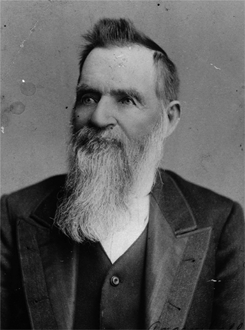
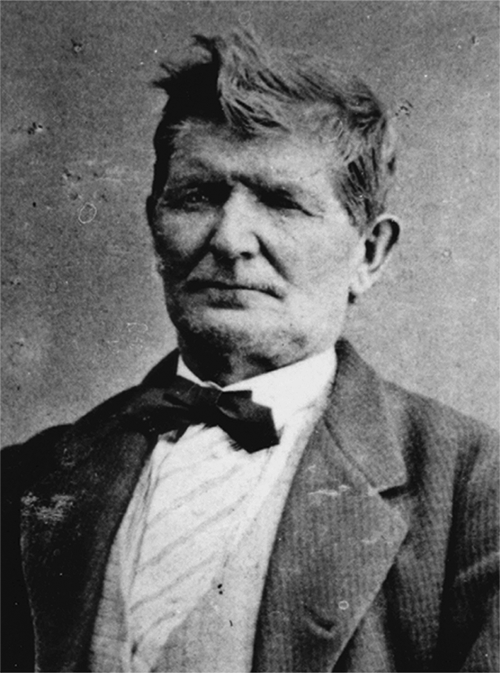
Company organization was typical. Joseph Horne, who had come north along the route the winter before on the return leg of Parley P. Pratt’s southern exploring trek, would pilot the settlers. Henry Lunt (see illus. 2-1) would act as Smith’s “private clerk” while John D. Lee would be “general clerk of the camp.” Since the wagon train would comprise some 100 wagons, once it reached full strength, it was organized into two companies of 50 or so each. Anson Call was appointed captain of the “1st 50” and Simon Baker captain of the “2nd 50” (see illus. 2-2). These groups were further divided into “10s” (subgroups of 10 wagons each), as shown in sidebar 2-1, “Traveling Company Organization.”7
Illus. 2-2. Anson Call (1810–90), captain of the 1st 50, who shared duties on the trail with Simon Baker (1811–1864), captain of the 2nd 50. Courtesy LDS Church Archives.
Although Henry Lunt seems to make no mention of them, both George A. Smith and John D. Lee frequently refer to “horse teams,” but without further description. Context certainly implies horses hitched to wagons, but their exact relationship to the ox-drawn wagons generally and the 1st 50 and 2nd 50 specifically is never made clear. Since they are most often sent ahead of the main body for one reason or another, we can assume they were the fastest and most versatile component of the train. Whatever the precise configuration, members of the Iron County Mission left Fort Utah on 16 December and headed south, marked only by Henry Lunt’s understated journal entry, “Started at 9 a.m.”8
Since the iron missionaries were generally following the route taken by Jefferson Hunt and Parley P. Pratt, signs of these earlier trains would still be visible. Virgin meadow and tree stands untouched by pioneer axes could easily be distinguished from soil rutted by hundreds of wagons and trod upon by scores of horses and oxen—even if the trail lay under several inches of snow. Heavily laden wagons quickly cut through topsoil, creating deeper ruts with each passage. Succeeding trains could pass to either side of the deepest grooves, terrain permitting, but even the widest roadways could sometimes cause extreme difficulties for wagons, especially when being driven through heavy rain or snow.9
Winter conditions kept the iron missionaries on the road for over four weeks. They had to take seed to plant in the spring and enough food to survive on until first harvest. Anything needed had to be brought; thus the wagon train also carried chickens, dogs, cats, geese, grain, corn, flour, guns, knives, ammunition, farming implements, tools for making iron, quilts, cooking pots, clothes, medicines, tonics and dishes. Most of the route was snow-covered. Although many of the travelers probably wrapped burlap over their boots for insulation, frostbite was common. Wagon stoves provided a little warmth when fuel was available. Later, as coal fields were identified, travelers heated their wagons by filling large tin tubs with glowing coals.
Winter travel was hard on the draft animals. The horse-drawn vehicles, presumably acting as advance parties, at times broke trail, but most of the wagons were pulled by slow, powerful oxen. Ice and rocks made even these sturdy beasts tender-footed and when they broke snow crusts for water their mouths became sore. Forage was scarce and they had to paw away snow to find winter-killed grass. They also ate sagebrush tips and browsed among cedar trees. Occasionally they received an allowance of precious grain.
The journals documenting the trip do not answer all our questions about the difficulties of daily life. There is little, for instance, about cooking meals over damp sagebrush or willow sprigs in sub-zero temperatures, about maintaining even the most basic level of hygiene among close-quartered travelers or about handling not only routine medical needs but also sudden, even life-threatening, crises on the trail. Nevertheless, it is intriguing to retrace, day by day, the long winter journey of the iron missionaries in such records as the Journal History of the LDS Church and the diaries of George A. Smith, Henry Lunt and John D. Lee (see illus. 2-3). For the most part, these sources agree. Minor discrepancies appear because daily entries were not always possible. The practical demands of wagon train life left precious little time and energy for journal-keeping.
Illus. 2-3. John D. Lee (1812–77) kept a detailed journal of the Iron County expedition, and later founded Fort Harmony, southwest of Cedar City. Courtesy LDS Church Archives.
Of central importance, nevertheless, are the perspectives of the three diarists. As a recent emigrant from England, Lunt did not concentrate on trail conditions as Lee and Smith did, yet he was more sensitive to problems of comfort and convenience than the task-focused leaders. Smith’s journal and Lunt’s diary frequently contain the same phrases. We assume Smith copied from Lunt on occasion, since Lunt was Smith’s private clerk and would keep the official record up to date, Smith having too many claims on his time to do so. Compared to the somewhat general entries made by Lunt and Smith, Lee’s phrasing is more distinct, containing many syntax and spelling variations but also additional detail.
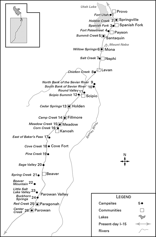
A daily log of the trek south, collated from the three accounts, follows. It includes each day’s camping place, with weather, trail condition and natural feature observations. Campsites and trails can be located with considerable confidence, using site descriptions and mileage records from the primary sources (see illus. 2-4). To help the reader follow the journey south, an accompanying sidebar (2-2) provides a list of pioneer place names with their modern equivalents.
Illus. 2-4. Iron Mission Campsites from Fort Utah to Parowan, 15 December 1850–13 January 1851.
Travel Log
Camp 1. Sunday, 15 December 1850: Fort Utah (Provo).
Wind: south
Morning temperature: 30 degrees
Noon temperature: 42 degrees
Evening temperature: 30 degrees
Distance traveled: 5 miles
Weather: slight snowfall
Iron missionaries from Salt Lake and Utah Valleys had been assembling since 7 December at Fort Utah. It was here, on 15 December, that George A. Smith organized the pioneers into two traveling companies. Sometime during the night, Lunt noted, wolves killed one of the camp’s ponies. After a discussion with Isaac Higbee of the local bishopric, Smith secured the services of young Thomas Wheeler, fluent in “the Utah language,” to accompany the iron missionaries as interpreter during expected encounters with Native Americans.10
When the Mormons settled in the Salt Lake Valley, they found an area realtively uninhabited by Indians, although the Shoshoni from the north met there to trade with the Utes from the south. Utah Valley, on the other hand, was the home of the Timpanogos Utes and a rendezvous for other groups as well. Utah Lake teemed with fish and wildlife was abundant.11 Because the valley was strategically located along the Mormon Corridor to California, Brigham Young was anxious to plant a colony there even though the Timpanogos Indians were constantly fighting each other. In April 1849, 33 pioneers settled on the Provo River (named for explorer Etienne Provost). By the time Pratt’s Southern Exploring Expedition passed by that November, Fort Utah had expanded to 57 log houses.12
The uneasy co-existence between natives and newcomers exploded into conflict when, in January 1850, three Mormons killed an Indian accused of stealing a shirt and, filling the body with stones, threw it into the Provo River. In retaliation the Utes attacked the fort and threatened to eliminate the settlement. Brigham Young, informed of the Indian hostilities, but not of the murder which aroused them, ordered the pioneer militia to drive the Indians out of Utah Valley. Over 30 Indian braves were killed, with others escaping to the Spanish Fork River. Although peace was negotiated with the remaining Utes, George A. Smith knew his expedition was traveling over disputed territory.13
Camp 2. Monday, 16 December 1850: Hobble Creek (Springville).14
Wind: northwest
Morning temperature: 20 degrees
Noon temperature: 44 degrees
Evening temperature: 34 degrees
Distance traveled: 6 miles
Weather: very muddy roads
According to Lunt, the two companies left Fort Utah at 9:00 a.m. They could rarely leave earlier—the long winter meant late dawns and early sunsets, often allowing only five or six hours of travel before seeking the next campsite.15 The first stop was Hobble Creek, where they camped on the south bank at 5:30 p.m. Oliver B. Huntington and Barney Ward had explored the area in February 1849 as far south as the Spanish Fork River. During their night’s camp, the bell horse broke its hobbles and strayed northward. They found it, hobbles still attached, near modern Springville, which they first named Hobble Creek.
When the iron missionaries stopped at Springville, the fortified settlement was just three months old. Only John D. Lee mentions it—perhaps because the train passed some distance to the west. Their route roughly parallels modern I-15.
Camp 3. Tuesday, 17 December 1850: Spanish Fork.
Wind: southeast
Morning temperature: 32 degree
Noon temperature: 42 degrees
Evening temperature: 36 degrees
Distance traveled: 6 miles
Weather: 2 inches of snow that quickly melted, leaving the road muddy
The party left Hobble Creek at 10:30 a.m. In attempting to cross the Spanish Fork River around 2:00 p.m.,they found themselves in a deep quagmire. The swampy passage was so difficult that Matthew Carruthers’s wagon became completely trapped. Meanwhile, men worked to free other wagons, which, according to Lee, “required 9 yokes of oxen to get them through the sloughs.”16 Once they camped at 4:00 p.m. (or perhaps on the day following), the leaders considered the possibility of diverting the river into a more fordable channel and bridging it for future travelers. The route continued to roughly parallel present-day I-15.
Camp 4. Wednesday–Thursday, 18–19 December 1850: Fort Peteetneet (Payson).
Wind: southeast
Morning temperature: 29 degrees
Noon temperature: 44 degrees
Evening temperature: 30 degrees
Distance traveled: 5 miles
Weather: 3 inches of snow
On horseback, George A. Smith, with Lunt and Lee in their respective offices of private clerk and clerk of camp, left ahead of the main body and detoured to Fort Peteetneet, so-named for a local Ute chief, Wakara’s uncle. The wagon train broke camp on the Spanish Fork River at 10:30 a.m. and wound its way along the still-swampy route to make its next camp at 2:06 p.m. near the fort at the northwest corner of present-day Payson. James Pace, who hosted the Iron Mission leaders, had begun the colony with only 25 settlers. In March 1851, while visiting the Utah Valley settlements, Brigham Young would rename Peteetneet in honor of its founding settler. First known as “Pacen,” the spelling evolved into “Payson,” by which the town is known today.17
The first three days of the journey had been a useful shakedown. The pioneers shifted loads, made adjustments and waited for trailing wagons, knowing an extended line of march would be a liability as they entered Indian territory. For Smith, Lunt and Lee, much of the time was spent in writing. Smith drew up a petition for a bridge over the impassable slough and another regarding timber and irrigation rights. He dictated numerous letters, including one to Brigham Young, and took an inventory of equipment and supplies (see sidebar 2-4, “Iron Mission Caravan Inventory,” below). He also organized a militia for Iron County (see sidebar 2-3) with himself as major and John D. Lee as adjutant. Nor had Smith forgotten Matthew Carruthers’s wagon, still mired in the slough. He ordered an empty wagon and sufficient teams sent out to unload the bogged-down vehicle, insuring that Carruthers would be able to “role on, as he was wanted to go particularly as he was acquainted with manufacturing Iron.”18
Late in 1840, the Nauvoo Charter, granted by the Illinois State Legislature, had authorized a city militia called the Nauvoo Legion, led by Joseph Smith as Lieutenant General. This military organization was reestablished in 1848, after the move across the plains, under the direction of Charles C. Rich, and was sentimentally called the Nauvoo Legion after its predecessor. On 28 April 1849 the provisional State of Deseret reorganized the Nauvoo Legion, consisting then of 11 companies (six cavalry and five infantry), into geographical military districts.19
John D. Lee recorded that the men of the Iron Mission also organized themselves into four military companies (distinct from the traveling companies already formed).20 As George A. Smith explained in his letter to Brigham Young, written at Fort Peteetneet:
Our military organization may appear strange to some of the officers of the Nauvoo Legion, and in fact some of the Iron County officers thought it rather odd. But it was organized to suit the wants of the Camp under our present circumstances.
Taking the census of Iron County and also organizing and appointing and qualifying a Judge to preside over it before there is a single soul in it would to parlimentary men seem equally as odd. Should not this organization meet with your approbation, please write, and any change you may suggest, will be promptly attended to.21
While camped at Fort Peteetneet, Smith had received a letter from Brigham Young written 16 December 1850 outlining some contingency plans if the weather were to stop their southward progress:
. . . we would recommend to you, if you cannot get further than Salt Creek, that we want a good settlement there; if you can get as far as Beaver Creek and should get hemmed in with winter, we also want a good settlement there, and as soon as the winter disappears, you can then lead out for Iron county, to fulfil your present instructions.
Should you be hemmed in by winter at either of the before mentioned places, it will be well for you to build a fort, make yourselves secure, and when you leave in the spring, leave from ten to twenty men in each or either Fort until more assistance can reach them from this place. There is not the least fear but that your cattle will do well any where on the sides of the mountains, for feed is everywhere abundant and fuel can be obtained at a very short distance from any point. The reason that we are so very explicit is, that you may not hurry, or kill any of your cattle, but preserve them and yourselves, and accomplish all the good you can. And may the God of Israel bless and prosper you, in all that you put your hand to do, and that you may return in safety to the bosom of your family and the society of those whom you love dearly in the kingdom of our Lord Jesus Christ.
Brigham Young
P.S. Please make out a schedule of your camp and leave with James Pace at the Peteetneet to enable me to take the census.22
Here at Peteetneet, two and a half years later, on 18 July 1853, the first shot in an escalating conflict between Wakara’s Utes and the Mormon settlers would be fired. It would become known as the Walker War.23
Camp 5. Friday, 20 December 1850: Summit Creek (Santaquin).
Wind: southwest
Morning temperature: 20 degrees
Noon temperature: 34 degrees
Evening temperature: 22 degrees
Distance traveled: 7 miles
Weather: 5–8 inches crusted snow on the ground
By this day, some members of the party were eager to move on. Smith sent riders out to check on straggling wagons but finally gave permission for the main company to proceed. Smith, Lee and Lunt remained at James Pace’s, working until midnight on the travel roster and fair copy of the inventory of supplies and equipment.
Most of the camp moved out by 9:00 a.m., probably under the direction of Anson Call and Simon Baker, the two captains of 50, and pilot Joseph Horne. A letter from George A. Smith, printed in the Millennial Star, gives a colorful summary of the departure:
We numbered one hundred wagons, and a number of carriages, and I assure you it was a sight to behold, to see this number of wagons winding among the hills and mountains, with each wagon having a stove pipe smoking, looked like a line of steamboats, the ground being at various depths, covered with snow.24
The wagon train traveled three and a half miles through five to eight inches of crusted snow on its way to “Summit Creek” where, Lee says, the men made camp around 4:00 p.m. Gustive Larson, who edited Lee’s journal for publication, believes this is either a reference to Clear Creek (modern Spring Lake) or an inadvertent mileage error, since Summit Creek (modern Santaquin) is some six miles from Payson, the previous camp.25
Meanwhile, a Brother Gardner, apparently posted on top of James Pace’s house to observe the road back to Spanish Fork River, reported the approach of the straggling wagons.26 Eight arrived in the evening while three others were still in trouble at the slough. Once again, “an empty waggon & some 5 or 6 yoke of oxen” had to be sent back to rescue them. Despite these frustrations, the company made progress, all three journals agreeing that most of the wagon train traveled seven miles from Peteetneet (Payson) to Summit Creek (Santaquin), while Lee adds a comment on Saturday that shows they passed through Clear Creek (Spring Lake) as well.27
Camp 6. Saturday, 21 December 1850: Willow Springs (Mona).
Wind: north
Morning temperature: 19 degrees
Noon temperature: 30 degrees
Evening temperature: 22 degrees
Distance traveled: 12 miles
Weather: 4 inches of snow
The main party left Summit Creek at 9 a.m., closely paralleling U.S. Highway 91 (no longer in use), traveling to a site Henry Lunt identified as Willow Creek or Willow Springs. George A. Smith and his clerkswaited no longer for the 11 straggling wagons (presumably those of Captain Bringhurst), but headed out to catch up with the main company at this site, which Smith calls “Jewab Creek.” (He is the only journal-keeper to mention passing, around 10:00 a.m., “a man, the name of Jones” going in the opposite direction. This was William Jones, the only iron missionary to defect from the southward journey and return to Salt Lake.) The three riders reached Summit Creek camp, which the main party had already vacated, and met up with them at “Jewab Creek.” Juab was the white settlers’ version of a Ute word, Yoab, pronounced Jew-ab, meaning flat and level. Smith gives their travel distance from Fort Peteetneet to this camp as 19 miles; Lunt, tracking the main party’s mileage, puts their progress on the 21st from Summit Creek to “Juab Creek (now Willow Creek)” as 12 miles. These measurements place Camp 6 near the site of present-day Mona.28
Camp 7. Sunday, 22 December 1850: Salt Creek (Nephi).
Wind: west
Morning temperature: 17 degrees
Noon temperature: 24 degrees
Evening temperature: 20 degrees
Distance traveled: 8 miles
Weather: cloudy; afternoon snowstorm
Because of the cold weather (17 degrees) and absence of good firewood, George A. Smith authorized a Sunday drive to Salt Creek, 12 miles away. Leaving a note for the stragglers, which included a reminder to keep their wagons together and guard their teams, the main body moved on, reaching its destination between 2:00 and 3:00 p.m., camping on the south side of the creek where the pioneers found “First rate Bunch Grass water & wood.” At 4 p.m., Smith called a meeting to explain “that he did not aprove of Traveling on the Sabbath but that circumstances advised us to do so at this time & when necessity required us to travel on Sunday he believed that the Teams—should have a time through the week to rest.”
A major debate arose over Smith’s plan to have a bridge built over Salt Creek, anticipating Brigham Young’s visit south that coming spring. “The majority of the camp thought it useless to stop & Bridge the stream as it would likely never be past Fording,” recorded Lee, but Smith repeated the need to carry out President Young’s wishes. This was sufficiently convincing and the camp sanctioned the plan.29
Their route this day would have paralleled old U.S. Highway 91 from Mona to Nephi, scarcely eight miles, yet Lunt gives the distance as 11 and Lee says it was 12.30 Examining the evidence, we can question their accuracy here. The group traveled six or seven hours, starting at 8 a.m. and stopping at 2:00 or 3:00 p.m., depending on the journal cited. The trail was frozen and slippery with three inches of snow. All these conditions would have made 12 miles an extraordinary achievement for the short wintry day.
Camp 8. Monday, 23 December 1850: Chicken Creek.
Wind: northeast
Morning temperature: 16 degrees
Noon temperature: 46 degrees
Evening temperature: 21 degrees
Distance traveled: 15 miles
Weather: cold; low clouds; snowing in the mountains
After breakfast, “as many men as could be employed to advantage . . . laboured till 9 when the ox teams roled on & the Horse Teams remained on the ground & finished the Bridge.” This entry from Lee’s journal is the first to mention horse teams as a distinct unit. Lee also notes that George A. Smith stayed behind to see the work through. Stragglers were beginning to catch up, for Smith writes that “[t]he rear Ten which we left at Capt. Paces crossed it, and pronounced it a good bridge. We called it the Rear Bridge.” The day was dull and cloudy, the road slick and muddy, but past the small summit south of Nephi the track was mostly downhill. The ox-team company camped at Chicken Creek at 4:30 p.m., a quarter of a mile east of the road, at a fine spring.31 Lee notes that “about Sun Set the rear of the camp roled in caral,” bringing the Iron Mission as close to full strength as it had been thus far. All three journals record the distance from Nephi (Salt Creek) as 15 miles.32
Chicken Creek was a day’s travel from Nephi, heading south, and the same from the Sevier River ford, heading north. There were no traditional campsites along these trails; wagon masters and individual travelers preferred to make their own. Favored sites had grass for the animals, a generous spring and firewood on the west hillsides, but also enough open area to reduce the risk of Indian attack. Probably any location between the Juab rail siding and present-day Chicken Creek Reservoir Dam would be a candidate for this particular stop.33
According to modern survey maps, various springs can be seen in Sections 16, 17, 20, 29 and 30 of T15S, R1W.34 The Juab siding is very close to 15 miles from Nephi. Given this distance plus Smith’s description, the Chicken Creek campsite may have been in Section 9 or 10, T15S R1W.
Camp 9. Tuesday, 24 December, 1850: north bank of the Sevier River.
Wind: northeast
Morning temperature: 10 degrees
Noon temperature: 34 degrees
Evening temperature: 6 degrees
Distance traveled: 16 miles
Weather: clear and cold
Three inches of snow fell on the camp during the night of 23–24 December. The travellers were already facing a new swamp, this one between the campsite and Chicken Creek. George A. Smith, concerned about the Sevier River crossing nine miles south, dispatched four experienced men that morning—Anson Call, Elijah Newman, Tarlton Lewis and William Leany—to explore ahead and consider bridging the river, while Simon Baker and Joseph Horne sought a passage around the swamp.35
Baker and Horne returned to the camp about 8:00 a.m. the same day and recommended swinging east around the head of the springs, then turning south, adding seven miles to the journey but avoiding the swamp.36 The four men sent to appraise the Sevier River returned to report that the stream was “at least 150 feet wide & no material for building a Bridge excepting ceder . . . not Much tauler than sage.”37
The company’s drive to the intended crossing took a whole day of unpleasant travel “over a barron Hilly broken country covered with greesewood sage &c but no feed” until the Sevier River. To reach a campsite near its banks, they descended a steep hill that was slippery and dangerous for the wagons and teams.38
This route apparently followed the southward drainage of Juab Valley to its southwestern tip, then went through the low-lying pass known today as Chris Creek. The “steep hill” would have been the bluff overlooking the northwestern tip of the Sevier Bridge Reservoir. Although the temperature had risen to 34 degrees by noon, it began “freezing very sharp” by 5:00 p.m. One hour later, when the wagons reached the river, the thermometer read six degrees.39 The teams slithered down to the snow-covered, muddy bank and prepared to spend a cold night there.
Camp 10a. Wednesday, 25 December 1850: south bank of the Sevier River; one-half mile below the ford.
Wind: south
Morning temperature: –12 degrees
Noon temperature: 32 degrees
Evening temperature: 4 degrees
Distance traveled: one-half mile
Weather: clear; hard frost
Christmas Eve had been their most chilling night yet. As they got underway Christmas morning, the temperature was 12 degrees below zero. Sagebrush fires were hardly adequate against the piercing south wind. The party celebrated Christmas by cutting down the bank of the river enough to begin fording by 11:00 a.m. Reluctantly, oxen and horses inched into the ice-laden stream, the water coming almost to the animals’ bellies and the bottoms of the wagon boxes. The exit point across the stream was a steep yellow bluff, especially slick for the unshod oxen. Even so, “all but two wagons were crossed this day; no accident occur[r]ed.” According to Lee, the fording took from midday to just past sundown.40
As they climbed up the south bank, the wagons moved downstream half a mile to camp in better shelter, although feed was poor and the animals had to be pastured away from camp. As night fell, the main party saw 11 more wagons arriving on the north bank. It was Captain Bringhurst’s stragglers who had been in the rear since leaving Peteetneet.41
Camp 10b. Thursday, 26 December 1850: Sevier River.
Wind: southeast
Morning temperature: –16 degrees
Noon temperature: 28 degrees
Evening temperature: 4 degrees
Distance traveled: none
Weather: clear; hard frost
Christmas night was even colder than the record-breaking Christmas Eve. The settlers had turned their oxen loose to graze for the night, but some, including two of George A. Smith’s, were missing the next morning. While the wagons still on the north bank prepared for their own slow task of fording, men were dispatched up and down river to look for the oxen. An Indian camp was reported four miles downstream, but Henry Lunt discovered the tracks of “two head of cattle and two Indians” leading toward the mountains.42
This was the Iron Mission’s first encounter with local tribesmen. To be on the safe side, Smith ordered 20 armed men, under Captain Fulmer, to go with Lunt. About 1:00 p.m., they returned with Smith’s oxen, Bright and Balley, both with arrow wounds. Bright had been shot twice in the shoulder, but Old Balley had 11 wounds. Smith had the wounds dressed with turpentine and salt, but when it became apparent that these measures could not save his life, George A. had him mercifully dispatched, penning an affectionate tribute:
The Oxen they had wounded were favourites with our family and had been in our Service ever Since we left Nauvoo and had travelled the road from their to the Gt Salt Lake Valley, three times over. They were at pres-ent owned by my brother, who loaned them to me for the Trip. They moved his family across the Plains and mine[,] ever faithful in all bad places, and perfectly handy and gentle, and willing to draw. I had formed an attachment for them, that is hardly conceivable to exist between man and beast. And when Old Balley goaded with eleven wounds, came up to my waggon tongue and lay down, groaning with pain and looking so wishfully to me for help myself and wife could not refrain from shedding tears. After dressing his wounds offering him food and giving him water which we had warmed, covered him with a Buffalo Robe. I felt that I could inflict almost any punishment on the head of his savage enemies, but when I come to see them [a father and 12-year-old son] two thirds naked (Thermometer below Zero,) half-starved and more than a third scared to death first thing I did was to give them some bread to eat, and place them under Guard until morning.43
In addition to losing what amounted to a personal friend, Smith had also lost an irreplaceable draft animal. But priorities had to be maintained. While the missing animals were searched for and brought back to camp, the wagons still on the north bank were examined by Smith and Baker and pronounced fit to begin fording. At the end of his long journal entry covering the unusual day, Smith noted that “Capt. Bringhursts Co. crost safely over the River and formed into our Carell into Capt. Bakers 50.” The whole of the camp was together.44
Camp 11. Friday 27 December 1850: Round Valley (Scipio).
Wind: southeast
Morning temperature: –8 degrees
Noon temperature: 36 degrees
Evening temperature: 3 degrees
Distance traveled: 9 miles
Weather: 9 inches of snow on the ground; a clear day; hard frost
The morning dawned clear and cold. After thoughtful consideration, George A. Smith passed judgment on the two thieves: with the help of the young interpreter, Thomas Wheeler, he claimed the boy in compensation for the dead ox, to which the father agreed, as the boy appeared willing. Smith had the boy dressed, fed and given to William Empey to rear, warning the father that no further misbehavior would be tolerated.45
He then moved the camp up the draw, south of the river crossing. The road was “slippery and sidling.” Lunt recorded that near the summit the men had to grip the wagons physically to keep them from tipping over. Their route can be seen from the modern road and requires little imagination to confirm the description. This troublesome pass was the site of Pratt’s Resurrection Camp the previous January, where two feet of snow had fallen in one night.
On the other side of the pass was Round Valley. According to Lunt, the group camped at 4:30 p.m. east of present-day Scipio, at a site providing plenty of cedar (half a mile away) and good bunch-grass for the stock, nine miles from their previous crossing.46 There was no water, but since the snow was some 10 inches deep47 they could easily melt it to drink.
Following camp assembly around 6:00 p.m., Smith consulted with the bishops, underscoring the policy that the horse teams would break trail and locate the most feasible routes to next water, while the heavier ox-drawn main body moved forward at a pace consistent with the strength of the animals and availability of forage.48
Camp 12. Saturday, 28 December 1850: Scipio Summit.
Wind: southeast
Morning temperature: 3 degrees
Noon temperature: 36 degrees
Evening temperature: 4 degrees
Distance traveled: 6–7 miles
Weather: old snow 12–14 inches deep on the ground
This day’s journey, one of the most strenuous, began at 8:00 a.m. in subzero weather and took the party to the top of what is now called Scipio Pass. About 14 of the horse-drawn wagons moved ahead, while the rest, mostly ox-drawn, struggled with delays. After only two miles, the party had to cross a deep ravine. Here, the “forward irons” broke on A. B. Cherry’s wagon. Repairs were made by lashing an iron bar across the break to form a splint. A wheel on Gideon Wood’s wagon also broke, “but necessity being the Mother of invention a Plough Beam was lashed on the under side of the wheel which served as a sleigh runner.”49
About two miles farther on they entered a canyon covered with scrub cedar and worked upward through deepening snow. To avoid another deep ravine, the party ascended the right side of the mountain. Simon Baker’s 2nd 50 stopped “a short distance back” to repair another wheel apparently broken on the climb, while the “forward 50” moved slowly ahead. About 3:30 p.m., they reached the summit “where we had a fair view of the Powvan Valley.”50 There was not enough daylight for the tired ox teams to descend the southern slope to Cedar Springs (also known then as Pioneer Spring and Explorer Springs, but now as Holden), so they made a dry camp in a little valley near some cedars.
Some of the exhausted oxen were left by the wayside between the summit and the evening camp. Lee makes a special point of recording the close relationship between George A. Smith and his slowly recovering ox, Bright:
Pres. G. A. Smith with his own hand took a camp kettle & by a Log heap Fire Melted Snow & watered his favorite ox which had been wounded at the Severe River by the Indians, the old fellow new well his Master’s waggon & frequently when Traveling would voluntarily walk in front [of] his waggon & crowd himself against the team as though he wished to assist by taking his place in Rank, others followed the Example, melted snow & watered their weak cattle.51
Camp 13. Sunday, 29 December 1850: Cedar Springs or Buttermilk Fort52 (Holden).
Morning temperature: 12 degrees
Noon temperature: 30 degrees
Evening temperature: 14 degrees
Distance traveled: 6 miles
Weather: 6 inches of snow; fine and frosty
The colonists roused very early. Smith gives the starting hour as 7:00 a.m., Lee even earlier, saying the cattle were yoked and the camp on the move by 6:30. Part of the group, presumably the ox teams,reached Cedar Springs53 at 1:00 p.m., as Smith says they overtook the horse teams there. Baker’s company came in around 5:00 p.m. The snow dwindled from two feet in the canyon to six inches at Cedar Springs.54 Here they had plenty of water, firewood and feed for the stock. Everyone felt a sense of achievement and relaxed after the strenuous trip over the summit. Smith records storytelling, talking and listening to music from violins and accordions while sitting around the campfires that night. With heartfelt satisfaction, he closed that evening’s journal entry, writing that
The perfect good humour which prevails and good health in the Company, notwithstanding the severe cold and deep Snows which we have had to encounter whilst passing over high Mountains which would be no small obstacle even in Summer, is really remarkable.55
Camp 14. Monday, 30 December 1850: Camp Creek or Chalk Creek (Fillmore).
Morning temperature: 16 degrees
Noon temperature: 32 degrees
Evening temperature: 18 degrees
Distance traveled: 12 miles
Weather: 3 inches of snow on ground; frosty day
The party resumed its trek south at 9:00 a.m. The hind axle broke on Andrew Love’s wagon near Pioneer Creek and Elijah Sheets, captain of the 2nd 10 in Call’s company, was sent back to help Love redistribute his load and tow the broken wagon to Camp Creek, some six miles ahead. Lee records that the name came from Pratt’s Southern Exploring Expedition having camped there, while Lunt and Smith describe the
same location, now Fillmore, as Chalk Creek because of abundant chalk deposits nearby. Not for the last time, George A. Smith noted the snow glare: “At midday . . . its effect on my eyes is almost unbearable.” Long exposure triggered severe headaches and near-blindness.56
The party had hoped to find enough large timber to bridge Camp Creek but there was none, so they forded instead. After camping at 4:00 p.m., they immediately began making charcoal so that blacksmith Burr Frost could mend Love’s axle. This involved splitting dry cedar and then burning it in a covered pit for about eight hours without letting it blaze, probably by keeping it lightly covered with dirt. Smith issued the instructions, estimating they could produce about 15 bushels of charcoal overnight. Around dark, Love, the wagons of his 10, and his “rescuer” Elijah Sheets, with his 10, brought Love’s broken wagon into camp.57
Camp 15a. Tuesday, 31 December 1850: Meadow/Meadow Creek.
Morning temperature: 22 degrees
Noon temperature: 32 degrees
Evening temperature: 22 degrees
Distance traveled: 5–7 miles
Weather: cloudy; cold; frosty
The morning was busy. Men from each company cut down the creek banks to improve the crossing, others helped prepare the temporary forge, some rounded up cattle and a few went with Elijah Newman in search of chalk. The charcoal-making efforts were successful and Burr Frost welded a reforged axle back onto Andrew Love’s wagon. The horse teams “remained on the ground” until repairs were done, but by 10:00 a.m. the rest of the camp had moved out. Smith notes that “Brother Shirts went down Meadow Creek for about eight miles hunting deer. He reported some cottonwood on the creek stream rapid, and as large as that of Camp Creek. It sinks at this place and forms a large meadow, excellent soil of a dark reddish color.” Although it was cloudy, Smith spent most of the day in his wagon, his sore eyes covered from the light.58
At 3:00 p.m., the brigade camped on Meadow Creek, a mile west of the present-day town of Meadow. The riders were impressed with the richness of the soil and the water, but the site lacked a nearby wood supply. At midnight, Edson Whipple, in his official capacity as Officer of the Guard, loudly wished the camp “Happy New Year!”59
Camp 15b. Wednesday, 1 January 1851: Meadow/Meadow Creek.
Morning temperature: 22 degrees
Noon temperature: 36 degrees
Evening temperature: 22 degrees
Distance traveled: none; day of rest
Weather: morning clear
Because Christmas Day had been taken up with the struggle at the Sevier, the company voted to lay over for New Year’s Day. Some of the men procured cedar from nearby hills while others rested. Still hunting deer, Peter Shirts went upstream, probably taking his sons with him. According to Smith, Shirts optimistically reported:
The Land excellent all the way accept about ½ mile of Sage Brush, went up the mountain which (he says is composed of red Sand Stone) about 3 miles; he could see an open Valley as far as the eye could extend, also a Lake which he thinks is 70 miles long, and many bodies of Ceadars on the Plains.60
Smith spent the day in his wagon listening to John D. Lee read The Poor Cousins, a “romance.” Meanwhile the wives of the journal writers—Zilpha Smith, Mary (Polly) Lee and Lovina Lee—prepared a festive dinner for their families.61 Joseph Millett records that he ate with the Smith family in their tent, also joined by “Pul-wah,” a French teamster working for John D. Lee.62 Lee identifies this individual as Paul Royls, and he is included in the Iron Mission roster both as “Pull Wah” and “Paul Ray.” Joseph Millet’s account also mentions Peter A. Smith (Dibble), the driver of Zilpha Smith’s wagon, as a teamster.63 By the light of a cedar bonfire, the pioneers held a dance that evening. Zilpha did not attend, “being some what fatigued from exercise.” The “exercise” was probably cooking all day around the campfire.64
Camp 16. Thursday, 2 January 1851: Corn Creek (Hatton, near Kanosh).
Morning temperature: 18 degrees
Noon temperature: 34 degrees
Evening temperature: 18 degrees
Distance traveled: 5 miles
Weather: cloudy and frosty
The camp set off at 10:00 a.m., traveled five miles over relatively easy terrain toward the lava-strewn area to the southwest and stopped at Corn Creek between noon and 12:30, leaving the remainder of the day for exploring. The site derived its name from the surprising discovery of land already under cultivation. John D. Lee recorded that
about 2 acres of land was fenced with willow poles sticking them in the ground at the distance of about 3 feet apart & with bark tied willow poles horrizontally across them & in those little gardens or patches corn wheat & Beans had been cultivated Brought to maturity & harvested this present season (that is now past) & from the appearance of stocks cobs & stubble the crops were of a Rich strong growth. . . . [O]n the North Side of this Stream near the field refered too, were signs of an heavy Encampment of Indians—from appearance had been encamped during harvest time & had left some time in Autumn—from the no[.] of Wickeups it was supposed that there must have been near 500 Indians.65
Peter Shirts once again made a foray up Corn Creek, finding “straight & handsome” cedar trees and “considerable Oak & some Maple.” “Above all,” he found “Iron ore of the best quality.” Shirts felt the canyon could be easily reached and its waters properly harnessed for powering “Mills & Machineries.” President Smith was particularly encouraged by this unexpected evidence of a land rich enough in resources and fertility to support a large population.66
Camp 17. Friday, 3 January 1851: east of Baker’s Pass.
Morning temperature: 12 degrees
Noon temperature: 28 degrees
Evening temperature: 10 degrees
Weather: dense fog; low-hanging clouds; no wind; 3 inches of snow on the ground; 10–15 inches on the summit
The journal accounts for this day do not exactly correspond, but from them we can make a fair composite of events. President George A. Smith instructed Barnard’s 10 and six teams of Bringhurst’s 10 (both of Baker’s 2nd 50) to accompany the horse teams, all of which were sent on ahead with Joseph Horne, the pilot. They were to break trail for the slower ox teams and find water as soon as possible—most likely Cove Creek, which lay some 20 miles ahead.
William Palmer, an early chronicler of southern Utah history, expressed the opinion in his personal writings that Baker’s 2nd 50 forged ahead at this point in an attempt to beat Anson Call’s 1st 50 into the Little Salt Lake Valley. The fact that President Smith himself ordered Baker’s men to advance with the horse teams belies the notion that the companies were engaged in an ox team race. On the contrary, as Lee notes, it was established policy “to change fronts” so that the physical strain on men, beasts and wagons might be distributed as equally as possible. All three journals note dense fog or heavy cloud this day. Lee documents an extinct volcano to their left, graphically describing its
large mass of huge rocks & broken fragments that lay scattered in every direction—that the convulsive groans of nature had tested the firmness of it[s] deep laid foundation upon examination the whole mountain had been doubtless subjected to the action of Fire; there being the appearance among the mass of burnt Lava & Pouris [porous] stone & even the large stone that remained partly whole appeared as though at some period of time that a welding heat had been taken upon them leaving them the colour of Rich Iron ore.67
Today this unique feature can easily be seen east of I-15 and it definitely locates the traveling route as east of and parallel to the modern freeway.
The advance contingent from Baker’s 2nd 50 under Barnard and Bringhurst traveled all day. Their pilot, Joseph Horne (see illus. 2-5), however, had never been over this trail going south. Becoming disoriented in heavy fog, he apparently mistook White Sage Flats (some 17 miles southwest of Corn Creek) for Dog Valley (almost four miles further south, to the east of the main trail). He was looking for the pass through Dog Valley to Cove Creek, but coming from the opposite direction, lost his way. As a result, he took his horse contingent into the mountains too far north to connect with the pass. Presumably it was at this point that his advance party split into two groups. All or some of the horse teams apparently continued forward in the fog, trying to regain the path. This left the ox teams of Barnard and Bringhurst partway up the northern slope of the mountainside, tiring fast, with some of them possibly near its summit. Horne sent back word “to inform the rear” that he “had taken the wrong r[oa]d he feared, & where it lead he had no idea.”68
Camp 18a. Saturday, 4 January 1851: Cove Creek (Cove Fort).69
Morning temperature: 0 degrees
Noon temperature: 50 degrees
Evening temperature: 28 degrees
Distance traveled: 9 miles
Weather: 15 inches of snow on the summit; cloudy and overcast.
After a night’s rest, Baker, who had remained with the main company, was delegated to reconnoiter on horseback and find the route for which Horne had been searching. Returning to camp by 9:00 a.m., he “reported a pass through the mountains about ½ mile to the right”70 of their present camp. On their way by 10:00 a.m., the party first crossed a short steep hill, then found themselves in a pass, where they “halted on a splendid spot of grass and let the teams bait about one hour.”71 The pass led directly to a little basin, through which they traveled for about five miles, finding themselves then where the “forward camp had been,” supposedly still lost.
The pioneers named the pass Baker’s Canyon. The basin became Dog Valley, after its prairie dog villages. Smith and the main body crossed Dog Valley and moved up a drainage area along foothills on the southeast side of the valley, ascending the hills to a second pass. The steep, dangerous trail required them to attach tow-ropes to the wagons to keep upright and maneuverable at the steepest places.72 Toward the summit, the force of the sun caused Smith to make a special note: “Whilst passing through the narrow ravines the reflection of the sun’s rays on the snow, was such that it sensibly affected our cattle and had no mercy on my weak eyes.”73
Aside from the problems Horne’s difficulties in the fog had caused, the travelers were beginning to come together. Once Horne and the horse teams reached the summit, they found themselves above the clouds, and the pilot quickly recognized where he was. About two miles past the steep passage, the main body reached a creek in a small valley resembling a cove, which they sensibly named Cove Creek. Here they found plenty of running water, good firewood and ample feed for the livestock. A little after dark, Lee noted, the rear of the company rolled into camp and “here the whole mission camped togather.”74
Camp 18b. Sunday, 5 January 1851: Cove Creek (Cove Fort).
Morning temperature: 28 degrees
Noon temperature: 40 degrees
Evening temperature: 28 degrees
Distance traveled: none
Weather: cloudy and thawing
On Sunday morning, Smith had the party up early checking on animals and equipment. He walked around the camp “animating and encouraging the men,” intending an early departure Monday. At noon, the group assembled inside the corral of wagons to listen to President Smith preach. He reminded them why they had undertaken their challenging endeavor in the dead of winter: while the world was motivated by self-interest, the iron missionaries were united in the cause of building Zion. Because of the “Justice and Righteousness . . . written upon every man’s Heart” camp rules were, as yet, unnecessary. He then offered practical advice, urging the men to be careful with firearms and to guard the precious livestock. He apologized for triggering resentment, in a previous sermon, among British members of the company by extolling American success in battles against England. “I hope never again to excite that kind of National Feelings,” Smith affirmed, since “all governments on earth but one are corrupt & that is the government of God.”75
At this meeting, Robert Wiley was appointed chorister of the “Iron County Choir,” consisting of Wiley, Richard Harrison, Henry Lunt, Thomas Cartwright, Richard Benson, John Sanderson, George and Mary Wood and William C. Mitchell Jr. and Sr. That evening Henry Lunt reported a “lively appearance” in camp as everyone gathered around the campfires, singing the songs of Zion.76
Camp 19. Monday, 6 January 1851: Pine Creek.
Morning temperature: 28 degrees
Noon temperature: 32 degrees
Evening temperature: 28 degrees
Distance traveled: 6 miles
Weather: cloudy and thawing; no new snow
The first task this morning was rounding up the stock, which had scattered after their full day of rest. Each journal notes how footsore the animals were, especially the oxen, who suffered from plodding relentlessly over crusted snow, frozen mud and rocks. One of George A. Smith’s oxen had a wooden stub imbedded in a hoof. Smith extracted it with difficulty, filled the cavity with tar and shod the ox, pressing his healing animal, Bright, into duty as replacement. Wolves had already killed three oxen since the trip began, and a fourth, from Jacob Hofhein’s span, was devoured this day.77
The camp got underway at 9:30 a.m., but after two miles, “the 1st 10 by order of the Pres” stopped until Edson Whipple could return from searching for his missing ox, which he found by midday. The going thereafter was relatively easy; the snow diminished rapidly. They traveled six miles, according to Lunt and Smith, seven according to Lee. The new camp offered plenty of grass and cedar for firewood. Because they could see a stand of what artist Solomon N. Carvalho later identified as “Norway pines” on a nearby mountain, they called this site Pine Creek.78
Camp 20. Tuesday, 7 January 1851: Sage Valley (Wild Cat Canyon).
Morning temperature: 28 degrees
Noon temperature: 36 degrees
Evening temperature: 22 degrees
Distance traveled: 9 miles
Weather: 12–26 inches of snow on the ground with drifts; light skiff of new snow
This day’s travel was more difficult. The train moved south about five miles through sage, scrub cedars and cobblestones, which further punished the oxen. Some of the men took the hide off Hofhein’s dead ox and made “moccasins” for their own beasts, an awkward and temporary remedy, but urgently needed.79
It is difficult to determine their exact route. Lee’s comments suggest the party passed through scrub cedar and sagebrush (near the current highway rest stop) to the head of the valley—east of and roughly parallel to present-day I-15. After reaching the summit near exit 125 of I-15, they turned east to avoid the nearly perpendicular walls of upper Mud Creek Canyon, probably then filled with drifted snow.80
By the time they reached the divide, the group had come about six miles. The remaining three took them across the heads of a few hollows draining into Wild Cat Canyon. They followed this canyon into what they called Sage Valley, probably camping slightly north of the modern I-15 Manderfield exit (exit 120).81
Camp 21. Wednesday, 8 January 1851: Spring Creek (Dry Creek, near present-day Beaver).
Wind: high
Morning temperature: 24 degrees
Noon temperature: 34 degrees
Evening temperature: 20 degrees
Distance traveled: 13 miles
Weather: snow squall till noon; 2 inches of new snowfall during the night; long morning storm, thawing later in the day
While most of the wagons broke camp, William Dame’s 4th 10 of the 1st 50 stayed behind, waiting for Dame to return from Pine Creek, where he was rounding up a missing cow. The rest moved south down a narrow sage-covered valley for about five miles and ascended to a higher table land of “green blue clay.” They continued south three miles to a creek 10 feet wide with cottonwoods scattered along the bank. This is presumably Indian Creek near where I-15 crosses it today.82
Next they ascended a hill, probably Last Chance Bench, giving them a panoramic view of Beaver Valley, which impressed them as a desirable settlement site. After another three-mile stretch, they camped on the north bank of Spring Creek (present-day Dry Creek, a branch of the Beaver River), about three miles west of modern Beaver, a mile south of the road from Beaver to Minersville.83
Camp 22. Thursday, 9 January 1851: Beaver Mountain or South Hills.
Morning temperature: 13 degrees
Noon temperature: 38 degrees
Evening temperature: 7 degrees
Distance traveled: 6 miles
Weather: 8 inches of snow on the ground; thawing
Early this morning, Smith sent Baker and Horne to scout a route on the south side of the Beaver River that would avoid the swampy ground ahead. The two returned about 9:00 a.m. with recommendations. Meanwhile, Anson Call had men working to cut down the steep banks at their intended fording, while others collected teams and prepared to roll. According to Lee, “about 10 [a.m.] the horse teams commenced crossing and was followed by the 2nd 50. The 1st 50 in the rear today.” A mile or more on, they came to the Beaver River, variously described as 20 to 30 feet wide and between one and two feet deep. They found a ford with a firm gravely bottom, probably a little east of Greenville and a little southwest of modern Beaver.84
After detouring around marshy spots and passing across good farming land, they ascended the foothills (the Greenville Bench) of South Hills, which they called Beaver Mountain.85 Sometime in the afternoon, Lunt records, they “commenced to ascend the Beaver Mountain,” passed through some scrub cedars, turned west, entered a canyon and followed it for a mile and a half to its head. In the canyon, Lee wrote, was a “smawl trail made by some of the California Emmigrants, probably last Fall.”86 Possibly the canyon Lee referred to is “California Hollow” (so identified on the U.S. Geological Survey 7.5 minute map). At least the location and the distances match. On this night, the 1st 50, led by Anson Call, plus 10 or so of the weakest wagons of Baker’s 2nd 50, camped at the foot of a steep mountain about six miles from the Beaver River. The faster contingents of the 2nd 50 had moved on and were camped three miles ahead.87
Camp 23. Friday, 10 January 1851: Little Salt Lake Valley.
Morning temperature: 15 degrees
Noon temperature: 38 degrees
Evening temperature: 28 degrees
Distance traveled: 6 miles
Weather: 8 inches of snow on the ground
About 9:00 a.m., notes Lee, “the co doubled teams & commenced roling up the mountain promiscously . . . without regard to the organization.” They climbed Beaver Mountain for about 60 rods (a little more than a fifth of a mile) where 10 inch deep snow forced them to physically hold the wagons on the trail. Some trees had to be cut to open a road, indicating they were no longer on Jefferson Hunt’s route of a year ago, as the trail would already be clear had he passed that way.88
Near the top of the dangerous climb, Smith broke the tongue bolt on a wagon. Lee records that one of his own wagons, “by neglect of the driver,” slid off the road against a dwarf pine. Lunt corroborates that “several of the wagons had the bows broken and covers torn.”89 On the summit, Smith climbed a pine tree and got his first look at Little Salt Lake Valley “through a low gap in a range of mountains.”90
The descent was equally difficult, a “steep, road crooked winding among the timber some rocks.” Lunt notes they had to rough-lock the rear wheels (chain them to the axle so they could not turn) for about half a mile.91
The company passed through a gap in a second range of mountains. Lee describes the “descent into the kanyon that leads into the vally” as especially rough. After journeying six miles, according to Lunt, they camped in the northeast end of the valley, which, wrote Lee, “seemed rather forbidding to a farmer especially. Scarce any thing to be seen but sage and greasewood.”92
They were finally in Little Salt Lake Valley, where Brigham had sent them. Just before stopping at the north edge of the valley, George A. Smith sent Aaron B. Cherry and Tarlton Lewis back to notify the stragglers. The last teams arrived at the new campsite after dark, around 8:00 p.m. The forward contingent of Baker’s 2nd 50 had split itself into two groups: the furthest ahead had already reached Red Creek (modern Paragonah); the rest of the forward group (about 25 wagons, then at Buckhorn Springs) were only six miles ahead of the main body.
Smith assembled this largest contingent at the foot of the mountain and, warning them that they were the “weak broken fragments of the co” and needed to be on the alert against possible Indian attack,
[I]nstructed them to discharge their pieces and reload them. The Brethren wished to make a little noise on their arrival in the valley. They fired the Cannon and 24 stands of small arms in plattoons, followed up by 3 cheers for Iron County and 3 for the Governor [of] Deseret. Every thing was conducted in good order, and without accident.93
But these celebrations met with an unexpected response. Those at Buckhorn Springs heard the firing and feared the main body was under Indian attack. They immediately sent Zechariah Decker and Peter Lish to find out what was happening, at the same time sending other messengers on to Red Creek in case a relief party was needed. The Red Creek group set a strong guard on their own camp while “quite a company” of their men left immediately to ride the 15 or so miles back to the main campsite. It took until about 2:00 a.m. for everyone to be assured that no attack was underway.94
Camp 24. Saturday, 11 January 1851: Buckhorn Springs.95
Morning temperature: 28 degrees
Noon temperature: 38 degrees
Evening temperature: 24 degrees
Distance traveled: 6 miles
Weather: thawing
Lee records breaking camp at 8:00 a.m., Smith and Call riding ahead to find an evening campsite, settling on Buckhorn Springs, about 40 rods off the road.96 The two men named the site for a large buck’s antler they found submerged there about four feet deep. The trip over the summit from Cove Fort to Beaver Ridge, with snow from eight to 15 inches deep, with some drifting, had drained their energies. Wagons were also breaking down due to the rough terrain. Gradually the weaker outfits dropped behind, joining an ever-increasing number of wagons in Smith’s rear echelon.97
The water at camp was “brackish” and there was no wood but the animals had plenty of coarse grass. The strongest teams must have reached Red Rock Canyon about noon or shortly afterward. The pioneers spent the afternoon shoeing lame cattle, fixing outfits and shooting rabbits—the main ingredient for evening stew. So many oxen needed shoeing that the company ran out of shoes and nails.98
Camp 25. Sunday, 12 January 1851: Red Creek (Paragonah).
Morning temperature: 24 degrees
Noon temperature: 40 degrees
Evening temperature: 26 degrees
Distance traveled: 8 miles
Weather: fine
Lee was anxious to move on after he identified the brackish taste of the spring as “saleratus,” alkali salts in the water, poisonous in large quantities to thirsty animals.99 By 9:40 a.m., Smith had them all on the road—the lame, the halt and the footsore. He and Anson Call rode ahead to prepare Red Creek camp for the coming of the rest of the party. On arriving, the leaders found most of the Red Creek men scattered in all directions, riding, hunting and looking for good farm sites, which Smith felt was inappropriate on Sunday. He declined an invitation to join eight of the brethren who were even then saddling up, saying he was too weary. Lee says Smith then “remarked cautiously” that “should they chance to meet any Bishops or Elders of Israel by the way please remind them to return & keep the Sabbath.” This “gentle caution” apparently shamed the would-be gadabouts into staying in camp.100
The last of the wagons following Smith and Call rolled in about 3:00 p.m. It was too muddy for assembly, but Smith called the captains of the company together for a staff meeting at 6:00 p.m. Speaking from his wagon, the president congratulated them on their unity and good will. Without any camp laws, except his counsel and advice, the group had “traveled near 260 m[ile]s over mountains snow & ice, at this inclemant season, without a fight or even one single quarrel.” He “hoped that the same good spirit that was with them on this mission might remain & be cherished with them always.” He concluded by announcing that Brigham Young wanted them to settle on Center Creek in Little Salt Lake Valley unless the facilities there were inadequate.101 They all agreed to move to Center Creek in the morning and begin work on a permanent settlement.
Camp 26. Monday, 13 January 1851: Center Creek/Fort Louisa (Parowan).
Eager to reach the journey’s end, the entire company was on its way by 8:00 a.m., with Anson Call’s 1st 50 taking the lead. Travel over partially frozen mud and snow was not difficult and they arrived at Center Creek, five miles away, by 1:00 p.m. George A. Smith, Anson Call, Simon Baker and Tarlton Lewis rode ahead to explore the area and select a campsite, choosing one in the mouth of the canyon on the north bank. On Saturday, the 18th, they moved to the south bank to avoid the chilly canyon breeze.102
In Smith’s words, “a great majority of our farmers who make up rye faces” complained that the soil was not suitable for farming. He immediately organized parties to explore the entire area the following morning. His focus was on identifying the natural features and resources in their immediate vicinity. Among Smith’s instructions, written down by Lee, was a directive to
let some 3 men go on the morrow up this kanyon with Bishop Lewis & examine for timber iron ore coal mill stone grit etc & bring anything that is strange & unknown—a specimen of any curiosity serves to talk about if nothing [else].103
Journey’s End
Given the rigors and dangers of the journey, casualties had been surprisingly light. There had been no deaths, even though 11 of the 30 women traveling with the party were pregnant.104 The only defection had been William Jones, a habitual swearer, whom Smith described on 21 December, less than a week into the trek, as a man “who got sick of a winter’s mission and was returning to the Salt Lake City.” Early in the journey, while staying at Peteetneet, Smith had privately estimated that at least 50 oxen would die. Much to his astonishment, out of the 368 which started the trip, only six had died along the trail, with two or three more dying after the travelers reached their destination.105
The successful journey augured well for the future. Despite the risks, exertions and discomforts posed by the long trek in the midst of a Utah winter, they had survived, cooperated, built bridges and cut roads for those who would follow. Brigham Young had sent a strong right arm into the southern wilderness.
Sidebar 2-1: Traveling Company Organization
Anson Call’s Fifty
Aaron B. Cherry (captain 1st Ten)
Elijah F. Sheets (captain 2nd Ten)
Elijah Newman (captain 3rd Ten)
William H. Dame (captain 4th Ten)
Orson B. Adams (captain 5th Ten)
Simon Baker’s Fifty
Wm. C. Mitchell (captain 1st Ten)
Tarlton Lewis (captain 2nd Ten)
John Barnard (captain 3rd Ten)
Andrew Love (captain 4th Ten)
Samuel Bringhurst (captain 5th Ten)
Source: Lee, Iron Mission journal, 15 Dec 1850.
Sidebar 2-2: Place Names along the Mormon Corridor (From north to south)
Pioneer
Modern
Fort Utah
Provo
Hobble Creek
Springville
Spanish Fork
Spanish Fork
Peteetneet
Payson
Summit Creek
Santaquin
Clear Creek
Spring Lake
Willow Springs
Mona
Salt Creek
Nephi
Chicken Creek
Chicken Creek
Sevier River
Sevier River
Round Valley
Scipio
Cedar Springs/Buttermilk
Fort Holden
Camp Creek/Chalk Creek
Fillmore
Meadow/Meadow Creek
Meadow/Meadow Creek
Corn Creek
Hatton, near Kanosh
Baker’s Pass
Baker’s Canyon
Cove Creek
Cove Fort
Pine Creek
Pine Creek
Sage Valley
Wildcat Canyon
Spring Creek
Dry Creek
Beaver Mountain
Beaver Mountain
Buckhorn Springs
Buckhorn Springs
Red Creek
Paragonah
Little Salt Lake Valley
Parowan Valley
Center Creek/Fort Louisa
Parowan
Little Muddy/Coal Creek/Cottonwood
Cedar City
Sidebar 2-3: Citizen Militias
The use of a militia (citizen soldiers) for defensive purposes and for the management of crises caused by natural disasters has long been an American tradition. Militias differed from other military forces in that they were composed of citizens who met periodically to drill, receive instructions and learn the discipline necessary to perform effectively in emergencies. A local militia force was necessary in the development of the western American frontier and was, for the most part, the only organized law enforcement agency in frontier areas. Congress provided for the establishment of militia units throughout the various states and territories, setting age limits of 18–45 years and prescribing the equipment each man was required to provide himself.
1850 Militia Organization for Iron County
Cavalry Company (35 men):
Almon Fulmer, captain
Thomas Smith, first lieutenant
James Lewis, second lieutenant
William H. Dame, first sergeant
Rifle Company (35 men):
James A. Little, captain
Elijah F. Sheets, first lieutenant
John C. Steele, second lieutenant
Isaac N. Goodale, first sergeant
Light Infantry Unit (34 men):
Edson Whipple, captain
Elijah Elmer, first lieutenant
Orson B. Adams, second lieutenant
Samuel A. Wooley, first sergeant
Artillery Unit (15 men):
Jacob Hoffeins, captain
James Lausen, first lieutenant
[no second lieutenant]
Asa W. Sabbin, first sergeant
Sources: Ralph Hansen, “Administrative History of the Nauvoo Legion in Utah” (master’s thesis, Brigham Young University, 1954); Lee, Iron Mission journal, 19 Dec 1850, original spelling retained; Baugh, Call to Arms, ch. 3.
Sidebar 2-4: Iron Mission Caravan Inventory, 20 December 1850
2. Joseph Millett, “Brief Account of Artemus Millett & Family,” 4, holograph in possession of Nanon (Mrs. John Reed) Corry, Cedar City, Utah, copy in SUU Archives, copy in Shirts Collection. The introduction becomes more detailed ca. Jun 1850; daily entries begin 17 Dec 1850 with muster of Iron Mission party in Provo. Daily travel account almost identical to Henry Lunt journal. Confusingly, Millett numbers both “sheets” and “pages.” Wording of 9 Jan 1851 entry—“now in 1928” and “80 years ago”—suggests the beautifully penned account is a later fair copy.
3. Smith, journal, 9–10 Dec 1850; see also Jarvis, Ancestry, 148.
4. John D. Lee, “Journal of the Iron Co. Mission,” 12 Dec 1850 (hereafter cited as Lee, journal); original in LDS Church Archives, published by Gustive O. Larson, ed., as “Journal of the Iron County Mission, John D. Lee, Clerk, December 10, 1850–March 1, 1851” in Utah Historical Quarterly 20 (Apr 1952); (Aug 1953); and (Oct 1953). References are to the published version. See also Robert Glass Cleland and Juanita Brooks, eds., A Mormon Chronicle: The Diaries of John D. Lee, 1848–1876, 2 vols. (San Marino, Calif.: Huntington Library, 1955; reprint, Salt Lake City: University of Utah Press, 1983), 1:133.
6. Lee, journal, 15 Dec 1850. Note that, in this era of pioneer settlement, bishops were often responsible for traveling companies of riders and wagons, rather than for a stable community within a specific geographical area.
7. Ibid.; Smith, journal, on the same date. Lee, on the 15th, does mention establishing the traveling organization; Smith, on the 18th, does not.
8. Henry Lunt, Life of Henry Lunt and Family, Together with a Portion of His Diary, 16 Dec 1850 (hereafter cited as Lunt, diary), formerly in possession of Paul Lunt, Cedar City, Utah. Typescript made 1955–56; now in Perry Special Collections. Separate typescript prepared and photocopies made available to family members at Lunt Reunion, 1970. The authors have closely compared this typescript to the BYU typescript. It is a close copy but occasionally inferior to the BYU typescript in content and much inferior in readability. The BYU typescript has been hardbound and stamped with the abbreviated title “Life of Henry Lunt.” At the time of this printing (Feb 2001), the Sherratt Library received volumes 2, 3 and 4 of the original Lunt diary.
9. Any pioneer journal kept on the trail shows what modern readers might call preoccupation with travel conditions, but concerns were proper and real. Wet weather could turn an easy passage on level ground into a nightmare of swampy delay, risking broken wagon parts and exhausted animals. Unseasonably hot weather could mean dry creek beds and insufficient water for man and beast. Disorientation in snow or fog could cost precious time relocating the trail or even cause a complete loss of direction, increasing the risks of general panic, injury or death.
10. Lunt, diary, 15–16 Dec 1850; Smith, journal, 16 Dec 1850.
11. Campbell, Establishing Zion, 96; Walker and Jessee, “First Contacts in Utah,” 1.
12. Campbell, ibid., 99; Walker and Jessee, ibid., 3–4; Smart and Smart, Over the Rim, 25.
14. Lee, journal, 16 Dec 1850. Lee describes Hobble Creek as a “handsome Fort containing 35 Families.”
15. Lee, journal; Lunt, diary: both on 16 Dec 1850. Lee says the “Leader of the camp roled out” about 10 a.m. George A. Smith, after 18 months in the Iron Mission, would be called to oversee the expanding settlements of Utah Valley.
16. Note that Lee discusses the slough on the 18th; Lunt on the 17th and 18th; Smith only on the 17th.
17. Smith, journal; Lee, journal; Lunt, diary: all on 18 Dec 1850; Madoline Cloward Dixon, Peteetneet Town: A History of Payson, Utah (Provo, Utah: Press Publishing, 1974), 5.
18. Smith, journal; Lee, journal; Lunt, diary: all on 19 Dec 1850. This quote is from Lee.
19. Ralph Hansen, “Administrative History of the Nauvoo Legion in Utah” (master’s thesis, Brigham Young University, 1954), 12, 20, 24.
21. Journal History, 20 Dec 1850. George A. Smith is alluding to the fact that the General Assembly had already organized Iron County and elected him as its chief justice on 3 Dec, before the iron missionaries had left Salt Lake. See Gustive O. Larson’s introduction to Lee, journal, 113.
23. Dixon, History of Payson, 7; Hubert Howe Bancroft, History of Utah 1520–1886 (San Francisco, Calif.: History Company, 1890; reprint, Las Vegas: NV Publications, 1982), 474.
24. George A. Smith to Franklin D. Richards, 28 Jan 1851, published in Millennial Star 13 (1 Aug 1851), 238 (quoted in Jarvis, Ancestry, 149).
26. Smith, journal, 20 Dec 1850. The man is probably Elias Gardner, included on the Nov 1850 “call list,” but who seems to be otherwise undocumented in the Iron Mission.
27. Smith, journal; Lunt, diary: both on 20 Dec 1850; Lee, journal, 20–21 Dec 1850. The quote is from Lee.
28. Smith, journal; Lunt diary: both on 21 Dec 1850. Father Escalante had named Willow Springs the Fountain of St. Paul. See Herbert E. Bolton, Pageant in the Wilderness: The Story of the Escalante Expedition to the Interior Basin, 1776 (Salt Lake City: Utah State Historical Society, 1950), 74. See also Alice McCune, History of Juab County, 1847–1947 (Springville, Utah: Art City Publishing, 1947), 139. Dr. Matthew McCune, a former surgeon in the British Army, suggested the name Mona in memory of his home town on the Isle of Man.
29. Smith, journal; Lee, journal; Lunt, diary: all on 22 Dec 1850. The quotes are from Lee.
33. The Chicken Creek crossing was probably near the present dam site for the same reason the dam was eventually constructed there: the crossing’s firm, rocky bottom. The site is now covered by the reservoir.
34. Mapping coordinates in Utah are based on a zero coordinate marker designating the “Great Salt Lake Base Line and Meridian,” the base line running east-west and the meridian running north-south. From the zero or “prime” marker, located on the corner of Temple Square in Salt Lake City, “townships” are blocked off as 36-square mile units, 6 miles per side. Each township block is further divided into “sections” one square mile in area, comprising 640 acres each, further divisible into quarter-sections as needed. A code such as “T15S R1W,” therefore, means “township 15 south, range 1 west,” or the 15th township south of zero, at a range of one township west of the same.
45. Jarvis, Ancestry, 150–51; Smith, journal; Lunt, diary: both on 27 Dec 1850.
46. The unusual name was reportedly given by Brigham Young in 1863. His personal telegraph operator, lawyer Scipio Africanus Kenner, was standing on the corner designated for the town square when Young was casting about for a name. See Stella H. Day and Sebrina C. Ekins, comps., Milestones of Millard: 100 Years of History of Millard County 1851–1951 (Springville, Utah: Art City Publishing, for the Millard County Daughters of Utah Pioneers, 1951), 388.
52. During the mid-1850s, Cedar Springs was known as Buttermilk Fort, due to the large quantities of fresh, cold buttermilk stored in the spring-houses of the settlers.
53. Cedar Springs and Pioneer Creek (identified by Lunt as “Explorer Creek,” 2–3 miles south) were favorite campsites with traveling parties. Several large springs constituted Cedar Springs, an area which measured three miles in circumference. David Fulmer, one of the iron missionaries, had camped there the previous winter as part of Pratt’s Southern Exploring Expedition.
54. Smith, journal; Lee, journal: both on 29 Dec 1850.
56. Smith, ibid.; Lee, journal; Lunt, diary: all on 30 Dec 1850. On 21 Oct 1851, Brigham Young—and a committee who chose the location as the site of the territorial capital—renamed it Fillmore, honoring Millard Fillmore, the president who had signed the bill establishing Utah Territory. Truman O. Angell, LDS Church architect and designer of the Salt Lake Temple, drew plans for a four-winged territorial capitol building, only one wing of which was constructed. Anson Call led the settlement company and headed construction efforts. The first and only full session of the territorial legislature to be held there opened on 11 Dec 1855. The last session—the eighth—opened on 22 Dec 1858 and immediately adjourned to Salt Lake City. See Day and Ekins, History of Millard County, 3, 14, 150–54. Also see William L. Knecht and Peter L. Crawley, Early Records of Utah: History of Brigham Young, 1857–1867 (Berkeley, Calif.: MassCal Associates, 1964), 268.
60. Ibid., 1 Jan 1851. Local residents believe that the rock for the state capitol built in Fillmore, 1854–55, was quarried from this deposit. The “lake” was probably not Sevier Lake but surface water appearing, in the distance, to be a permanent body of water. See Larson’s comment in Lee, journal, 256, n. 10.
61. Smith, journal; Lee, journal: both on 1 Jan 1851.
62. Millett, “Brief Account,” 1 Jan 1851, p. 7, sheet 4.
66. Ibid.; Smith, journal, and Lunt, diary: on the same date. Charles Hopkins of Lehi, Peter Robinson and Peter Bayes were the first white settlers here (1854). The Salisbury and Gilmore stages, which ran from Salt Lake City to Pioche, Nevada, and possibly Silver Reef, Nevada, stopped here at Corn Creek. Called Petersburg for Peter Robinson, the first postmaster, the townsite was later renamed Hatton after Richard Hatton, his successor. Several of the stage buildings still stand in the trees just east of I-15. In 1867, Brigham Young suggested resettling closer to the mountains to conserve water and avoid early frost damage to crops. The new site was named Kanosh, after the local Pahvant chief. A peace-loving man, Kanosh accepted the Mormon settlers and was baptized into their religion.
67. Regarding Palmer’s opinion, see Jarvis, Ancestry, 151–52. See Smith, journal, 3 Jan 1851. The quotation is from Lee, journal, 3 Jan 1851.
68. Lee, ibid.; Lunt, diary, 3 Jan 1851. The quotes are from Lee.
69. The historic site of Cove Fort was a favorite among later pioneer travelers. In 1866, Charles Willden established a small stockade there which he called Fort Willden. Brigham Young instructed Ira N. Hinckley to build Cove Fort in 1867.
74. Ibid.; Lee, journal, 4 Jan 1851. Smith’s phrase is “The whole Company is together.” It is not known how long the pioneer route from Dog Valley to Cove Creek, the site of future Cove Fort, was used. Horne’s route to this camp was more difficult than an alternate might have been: around the west edge of Dog Valley, following the present route of I-15 and bypassing Cove Fort entirely.
78. Ibid.; Lee, journal, and Lunt, diary, 6 Jan 1851; Solomon Carvalho, Incidents of Travel and Adventure in the Far West with Col. Frémont’s Expedition (New York: Derby and Jackson, 1857), 205. Carvalho, who traveled with John C. Frémont as expedition artist, was Brigham Young’s guest in 1854 at the negotiations which ended the Walker War.
79. Lunt, diary, 6 Jan 1851; Smith, journal, 7 Jan 1851.
80. Lee, journal, 7 Jan 1851. “Mud Creek Canyon” is a modern place name not used in this entry.
81. Ibid. “Wild Cat Canyon” is a modern place name not used in this entry.
84. Lee, ibid., 9 Jan 1851; Smith, ibid., and Lunt, diary, 9 Jan 1851. The quote is from Lee.
85. The names vary. U.S. Geological Survey maps designate this feature as “South Hills.” Some local residents use the name “South Greenville Hills,” while still others call the location “Rattlesnake Hills”—after the jeep trail leading south named Rattlesnake Trail. State highway patrol officers designate the place “Beaver Ridge.”
From hindsight and the topographically predictable route mapped for U.S. 91 and then I-15, some Beaver residents have assumed the Iron Mission party followed that route southeast of Beaver, up Nevershine Hollow and over the summit, there intercepting the Old Spanish Trail going west from Frémont Pass. However, the journal entries of Smith, Lee and Lunt would seem to imply that the company crossed Beaver Ridge through a low pass almost directly south of Greenville and east of the cave at the foot of what the pioneers called Black Mountain. From the Last Chance Bench north of Beaver, this pass is easily visible and, to first view, would appear to be the most logical route into Little Salt Lake Valley. It is indeed the shortest route, but it is not the easiest—at least, not for wagons.
Corroborative evidence about the route over Beaver Ridge comes from earlier explorers. Miles Goodyear, who perhaps knew the route better than any other early fur trader, had been over it several times using pack horses, a much easier method of transport than wagons. In fall 1849, Jefferson Hunt led a large train of 100 wagons to California. Journals from participants on that trek also suggest the route was over Beaver Ridge, rather than around it. Further evidence of a road over Beaver Ridge is the jeep trail on the U.S. Geological Survey 7.5 minute map series of the Greenville Bench and Buckhorn Flat quadrangles, which may be the old Iron Mission route. In Section 26, T36S, R8W, appears “California Hollow,” a cedar-covered ravine 1½ miles long. Hiking and driving this trail provide ample evidence that it follows an older road.
93. All three journal-keepers record this first view of Little Salt Lake Valley on 10 Jan 1851, although Lunt does not mention Smith’s climb up the pine tree. The quote is from Smith.
94. Smith, ibid.; Lunt, ibid., and Lee, ibid.: also on 10 Jan 1851. Lee identifies the two men by their full names, “Zachariah” Decker and Peter Lish; Lunt refers to them without names; Smith records them as “Z. Decker” and “P. Lish.”
95. On their way from Buckhorn Springs to Red Canyon, Lee noted “at the distance of about 4 or 5 ms some mound[s] spring to the left of the road” (journal, 12 Jan 1851). According to archeologist Joel Janetski, the mounds are part of a Frémont archeological site in the area of Cedar City on the south to Paragonah on the north. They lie between U.S. 91 and I-15 and the base of the hills. See Joel Janetski, “150 Years of Utah Archeology,” Utah Historical Quarterly 65 (spring 1997): 100–133. George A. Smith, who picnicked at the site in spring 1851, numbered the mounds at about 120, noting that “they are all the ruins of an Indian City, composed of dirt lodges, the roof of Earth had been supported by timbers, which had decayed or been burnt away, causing an hollow at the top of the mounds. The brethren in excavating, dug up Adobois, that were very hard, Charcoal, curnals of Corn and cobs which had been partly burnt. found bones of Animals, but no human bones. many pieces of pottery.” Smith, journal, 29 May 1851.
104. The following children were born to Iron Mission settlers in the first nine months of 1851 in Fort Louisa (Parowan): New Samuel Whitney, born 1 Mar, son of Francis T. and Clarissa Whitney; Elizabeth Miller, born 25 Mar, daughter of Robert and Eliza Miller; Elizabeth Lee, born 24 Apr, daughter of John D. and Polly Lee; Susannah Steele, born 28 Apr, daughter of John and Elizabeth Steele; Margaret A. Hall, born 11 May, daughter of Charles and Elizabeth Hall; James Lewis, born 21 May, son of James and Emily Lewis; Ann W. Whipple, born 7 Jul, daughter of Edson and Harriet Whipple; John D. Whipple, born 27 Oct, son of Edson and Mary A. Whipple; Orson A. Dalton, born 17 Nov, son of Charles and Juliette Dalton; James Topham, born 27 Oct, son of John and Betsy Topham; Henrietta Lemmon, born 19 Sep, daughter of James and Susannah Lemmon (original spelling retained; punctuation adjusted). The list is reprinted in Luella Adams Dalton, History of the Iron County Mission, Parowan, Utah (Parowan, Utah: Privately published, 1970), 66. There she notes that it was taken “From a paper found in William C. McGregor’s home when it was torn down. He was a former Bishop.”
105. Outside Smith, journal, 21 Dec 1850, the sole comment found to date on William Jones is in a letter from George A. Smith which he would shortly send to Brigham Young via the Deseret News (written 17 Jan 1851; printed 8 Feb 1851, pp. 205–06), where Jones is described as a “promising young man” who “could not leave off swearing, and chose to go where he could exercise his liberty.” The reference to oxen is from Lee, journal, 2 Feb 1851.