Upon arriving in Little Salt Lake Valley, the iron missionaries’ immediate task was to determine whether the Center Creek site would prove feasible for their principal settlement, as Brigham Young hoped it would.1 Their first priority, of course, was to secure food and shelter. Seed grain was precious, and replenishing it would be doubtful if the settlement site had poor soil. Timber availability also influenced site selection. Although the settlers could build adobe or stone houses or cottonwood log cabins, they still needed good quality planks large enough for doors, floors and roofs. All these needs had to be met for the new settlement even to take root. No wonder George A. Smith was “very earnest and much engaged about the present location for this Mission.”2
A major concern was the quality of the soil at Center Creek. Some of the settlers, many of whom were from England, did not like the look of the “bloody red” soil. Their reaction was to make “roy [wry] faces and say they can see no facilities there.”3 Edson Whipple identified one of the vexed pioneers as blacksmith Burr Frost. On the day the settlers arrived at Center Creek, Frost told Whipple that “if any man said that he liked this country, if he had common sense that he was a liar; for, said he[,] it is not fit for any body to settle in, and for us to think of settling here, it was the height of folly, and he would venture to say as to iron ore there was none there.” Whipple evidently did not share Frost’s attitude, for he described Frost pityingly as a “sorry looking fellow not having shaved himself since he left home; his beard was long and his face was longer.”4 Although George A. Smith deemed the soil acceptable (“I found a track of land which pleased me”5), he evidently wanted to explore further since the final decision could mean the success or failure of the mission.
First Explorations in the Valley
The colonists’ saddle blankets had hardly dried before explorers rode out on 13 January to assess settlement possibilities in the region. Tarlton Lewis and three men were dispatched to investigate the area around Center Creek Canyon, reporting on their return that Center Creek was “about one rod wide & 2 feet deep swift rapid current rock bottom & banks—Kanyon oppen for three ms which is the distance that it has been explored.”6 Aaron B. Cherry and four or five others were sent to explore the “next kanyon ahead,” while a third group went west to examine the area around the Little Salt Lake.7 Peter Shirts, apparently alone, was designated to explore Red Creek Canyon.8
In addition to the exploring parties, various work parties were assigned. One group was to construct a permanent bridge over the creek half a mile west of the encampment and move the camp downstream about three-quarters of a mile to the base of the knoll, where Pratt’s group had erected its liberty pole. William Adams and Joseph Hovey were given the task of making grindstones from native sandstone so the men would be able to keep their tools sharp when timber-cutting began. A third group, under the direction of Jacob Hofheins, captain of the artillery company, mounted the cannon. Bishop Elisha H. Groves was left in charge so that everyone leaving camp reported to him.9 Smith himself led the fourth and largest exploring party of some 20 men southwest of the encampment for 25 or 30 miles to get the lay of the land and appraise the resources along the Little Muddy. He took a three-day supply of food and a mounted escort consisting of Thomas Smith, Thomas Wheeler, John D. Lee, Almon Fulmer, William H. Dame, Ebenezer Brown, Anson Call, John Dalton, Charles Dalton, Leamon Bronson (also recorded as “Lemon Brunson”), Zechariah Decker, Gideon D. Wood, George Wood, James Lawson, Thomas Corbitt, Marius Ensign, Joseph Horne, Simon Baker, Charles A. Harper, John Webb and James Harmison (“Harmerson” in both Lee and Smith).10
Smith, Lee, Thomas Smith and Thomas Wheeler rode in Lee’s four-horse carriage, which had enough room for the men, journal supplies, candles, a thermometer and a number of books (including “Comstocks Geology,” almost certainly from J. L. Comstock’s eight-volume Outline of Geology published in Hartford in 1834), which Smith perused while he jostled along.
This fourth group left at 10:00 a.m., presumably as soon as Smith was certain that everybody remaining behind was productively employed. They traveled south-southwest along the Old Spanish Trail for about six miles, then stopped to noon at the Summit Creek crossing. Unexpectedly, they came upon a pack train of 42 animals, led by Jefferson Hunt, returning from his trek to California as guide to the large party of fall 1849. Accompanying him were Levi Fifield and his son, John Berry, James Brooks, Henry Gibson, Marshall Hunt and John Mackey. Levi Fifield and Marshall Hunt had been members of the Mormon Battalion and joyously greeted their former comrades, Decker and Dame.11
The northbound travelers had important news, which Lee recorded. First, there was Indian danger. A man named Isaac Brown, traveling with five animals several days ahead of the Hunt party, had disappeared and was presumed dead, a victim of Indian attack: “[T]hey saw where they supposed he met with his fate; there was signs where the horses were drove off. He also said that they saw Indians repeatedly & some were hostile but that they got through safe.”12 Second, Brigham Young had been appointed governor of Utah Territory. Gibson had in his saddlebags the New York Tribune issue reporting both the formation of the territory on 9 September 1850 and Young’s appointment. Third, the travelers reported that the California goldfields should be no temptation to the faithful: “[N]early all the Brethren that were at the gold mines from the beginning & had made fortunes were all broke & but few of them that can get credit for a meal victuals & have become poor worthless disapated creatures.”13
Hunt sent his seven men on to the Center Creek camp with the pack animals while he accompanied Smith in the carriage to the iron fields, with which he was familiar. Smith, Hunt and their mounted escort apparently followed Braffit’s Creek and Wynn’s Hollow through the hills to the Enoch-Rush Lake area, “a distance of about 14 miles, mostly sage and rabbit brush.” As Lee recorded:
about 5 ms N.E. of the Muddy [i.e., Cottonwood or Coal Creek] a low range of mountains puts in from the North & allmost divides the vally— on the west side of that range several springs brakes out & forms a lake (smawl) around it abundance of good feed & some good farming land.14
They camped for the night on the creek, which had plenty of cottonwood trees and grass for the animals. The site can be located fairly confidently at the cluster of mature cottonwoods north of the Cedar City airport and between the former Cedar and Cedar West LDS Stake farms, approximately between Sections 28 and 33, T35S R11W.
Smith and Lee retired to bed in Lee’s carriage at 11:00 p.m. but the 29-degree weather made sleep difficult. They talked until 2:00 a.m., “consulting the interest of this people & the best policy to build up Zion,” while many of the other men sat around the fire and talked over old times until daybreak.15 That morning, Wednesday, 15 January, Almon Fulmer took four men upstream while William H. Dame led a small party downstream, presumably going north,16 although the old Coal Creek channel went west through the Iron Springs area. George A. Smith, Thomas Smith, Jefferson Hunt and Thomas Wheeler took the carriage and headed for the iron deposits, accompanied by the rest of the group (about eight mounted men under the direction of Anson Call). They rode approximately eight miles to the southwest, examining the soil and appraising farming conditions. Near noon, they were in the small gap in the mountain range on the west side of the valley. Later, at Iron Springs, they turned their horses out to drink and graze. Leaving part of the group on guard, Smith, Lee, Hunt and eight others
ascended one of those hills or smawl mountains of Iron Ore distance about ½ mile found large quantities of ore Some appeared to have been subjected to the action of heat & was pronounced by some to be dead. However specimens of the ore rock & to be tested by regular and proper process—in this vincity [sic] are 3 hills of ore & large amount of free stone suitable for buildings & ceder in great abundance.17
This “smawl mountain” was most likely north or northeast of Iron Springs in the region that extends northward from the spring about five miles and holds sufficient iron deposits to provide large-scale successful mining to this day. The chunks of free iron, plus outcroppings of solid ore, were plainly visible. The cedar could be used for fuel and the water impounded for blast furnace power. The “free stone” was monzanite, a form of granite suitable for building. The phrase “action of heat” may refer to the explorers’ perceptions that the area had seen volcanic activity.
Suddenly, as Smith was to put in his journal that night, probably dictating to Henry Lunt, they found themselves no longer alone:
At 5 minutes to 12, noon. Several horsemen were seen rideing towards us in ful speed abt. 3 miles off when first discovered. Soon they reached the camp and proved to be Indians of the Utah Tribe, there were 7 in number well clad and rideing good Horses they rode up and shook hands with the Interpreter and others who were well acquainted with them: the leading one was old Peteetneet, after whom Peteetneet Creek was named. From them we learned that Walker the Hawk of the Mountains was a short distance South about 25 miles near the Euinta Valley, they were quite friendly and seemed glad that we were settling in Little Salt Lake Valley. Capt. Hunt and Webb gave them some tobacco which pleased them they then must smoke the pipe of Peace.18
Although this encounter was amicable, it underscored the need to select a defensible settlement site and must have occasioned no little talk once the iron missionaries returned to camp. That night, after supper, Smith called a council meeting at which the various exploring parties presumably reported their day’s findings. It is likely that William H. Dame aired his negative reactions to the downstream explorations; Almon Fulmer concluded the Little Muddy lacked enough water to irrigate the amount of land needed for a sizable colony.19 Probably a good portion of the evening was spent on appointing officials to serve the new county, so that Hunt could take the information back to Salt Lake with him.
“Sanctioned by the Convention”: Organizing Iron County
The Deseret General Assembly had created Iron County on 3 December 1850, less than two weeks before the iron missionaries departed. Although Pratt had named their destination the Little Salt Lake Valley, Brigham Young had already written disapprovingly on 20 November to John M. Bernhisel, the Mormon delegate in Washington, D.C., saying “The Little Salt Lake is a misnomer; it is nothing but a little saleratus pond, about half the size of the Hot Spring lake in this valley. We have therefore altered the name of that county, and owing to its immense stores of iron ore, have named it Iron county.”20 On 16 December 1850, Young’s courier had brought George A. Smith, camped at Peteetneet (Payson), a copy of the county ordinances that the legislature had created on 3 December:
AN ORDINANCE, to provide for the organization of Iron County. Passed, Dec. 3, 1850.
Sec. 1. Be it ordained by the General Assembly of the State of Deseret, that all that portion of country, lying in the southeast corner of the Great Basin; and being south of the divide between Beaver Creek and the Sevier River, and east of the Desert Range, extending south to the rim of the Basin, and east to the Wasatch Range of mountains; be and the same is hereby known and designated “Iron County.”
Sec. 2. The Chief Justice of said County, is hereby appointed and authorized to organize said County. He shall cause notices of election to be made, and receive and open the returns of said election; qualify the officers elected according to law; approve of, and file their bonds in his office; and make return of his proceedings therein, as soon as practicable, being prior to the first day of June next.
Sec. 3. All officers elected and qualified under the provisions of this ordinance, shall hold their offices until super[s]eded by due course of law. This ordinance to be in force from and after its passage, any law or ordinance to the contrary notwithstanding.21
It was signed by Jedediah M. Grant as Speaker of the House and Heber C. Kimball as Speaker of the Senate. Brigham Young as governor approved it on 9 December. George A. Smith was the chief justice described in Section 2. In that capacity, he resolved the company into a political caucus during the evening council meeting on 15 January to nominate a complete ticket of county officials.22 The nominating committee consisted of “Major” George A. Smith, “Lieut.” Thomas Smith, “Pilot” Joseph Horne, “Capt.” Anson Call and “Adjt.” John D. Lee. Together they made their one-party nominations, which were accepted by unanimous vote (although John D. Lee withdrew his candidacy for recorder since he would be gone for some time moving his family from Salt Lake City to the settlement). James Lewis was nominated in his stead. Thomas Smith, Simon Baker and John Barnard were appointed election judges and the meeting adjourned for an evening of conversation. Anson Call offered the evening’s prayer “around the camp fire.”23
Choosing the Best Townsite
The next morning, Thursday, 16 January, with the temperature hovering at eight degrees, Smith sent Fulmer and four other men back up the Little Muddy to check out Fulmer’s report that lack of irrigation water would handicap any colony’s growth there. Lee’s diary states that the party consisted of nine men: Almon Fulmer, Thomas Wheeler, Charles Dalton, John Dalton, Simon Baker, Anson Call, James Lawson, Charles A. Harper and George Wood.24 This second examination underscores the importance of the Little Muddy in settlement deliberations. Fulmer’s exploring party evidently rode east, up the Little Muddy, then retreated to its mouth and angled back north, over to Center Creek, while the main body under Smith went northeast, straight to Center Creek. Smith’s party nooned at Summit Creek where Hunt showed him a cache of wagon wheels, hand saws, planes, chisels, augers, spades and so forth, which he had left the year before. Smith could use them, Hunt said, providing Hunt could have access to the tools should he return to live there. By 4:00 p.m. both parties were back at the Center Creek campsite.25
The second report was again unfavorable: although the water flow in the Little Muddy was as great as that in Center Creek, contrary to Fulmer’s report, the canyon was narrow and building there would be difficult. Smith’s journal entry agreed that the stream was as large as Center Creek but stated the canyon was “open and accessable.”26 Lee describes the pioneers’ decision, taking everything into consideration, to reject the option of settling on the Little Muddy:
after a fair & thorough examination of the surrounding country the company agreed in one thing (& that was) this creek with all its advantages and facilities the richness of its soil etc was not the home of this mission at the presant. The face of [the] country looked desolate and even the surrounding objects seemed forbidding & fearful threatening of future consequences was plainly depicted on the countenances of every man who felt the weight interest & responsibility resting on them (the building up of Zion) Therefore the spirit bid them return home it [being] the only place that seemed like home to us.27
By “home,” Lee meant Center Creek; by “forbidding & fearful threatening of future consequences,” he may have meant evidences of volcanic activity in the area. Mount Vesuvius had erupted in 1844, just six years earlier, and a Royal Observatory on its slopes had produced a series of reports that were widely circulated. Some of the pioneers, at least, may have been aware of these.
While the townsite would be on Center Creek, the leaders decided to place the foundry near Iron Springs, about eight miles northwest of the Little Muddy and about 12 miles southwest of Center Creek. John D. Lee wrote:
The Pres advised the escort to strike for the direction of the encampment [at Center Creek;] in so doing the road would be shortened about 5 ms which would be quite an advantage to our encampment when we established an Iron foundary. We shall go back & forth occasionally as circumstances shall require.28
Seven factors seem to have been important in this decision:
1. With major ore deposits in the Iron Springs-Three Peaks area, workers would commute the 20-odd miles (round-trip from Center Creek) for family, social and religious activities. Building the foundry near the ore was deemed more efficient than transporting the ore to a foundry built near the settlement.
2. Cedar trees (for charcoal) and ample water near the ore deposits were further reasons for locating the foundry near Iron Springs. (The later discovery of coal on the Little Muddy would cause a major change in plans.)
3. Although the Little Muddy had the best land, there did not seem to be enough water to insure adequate irrigation. Nor did it have adequate timber for building.
4. At Center Creek, in contrast, although some of the group were dissatisfied with the land, there was an adequate water supply and the best and most easily accessible timber supply of all the canyons explored.
5. Parley P. Pratt and Jefferson Hunt had both advised settling on Center Creek.
6. Smith judged that a fort on Center Creek would provide better protection against Indian attack, although he did not specify his reasons.
7. The group had sought divine guidance and their impressions after doing so favored Center Creek.
Holding the First Iron County Election
If bringing the settlers away from civilization to a new townsite was the first task of Iron Mission leaders, the second was to begin bringing the forms of civilization back to the settlers. To this end, after the return of the exploring parties on Thursday afternoon, George A. Smith called a “convention” and presented the slate of nominations made the previous day by the Cottonwood Precinct at Little Muddy camp. The first election in Iron County would be held the next day, Friday, 17 January 1851, with John P. Barnard, Simon Baker and Thomas Smith as election judges. No other nominations were called for; apparently only one candidate was proposed for each office.
The next morning, Thomas Smith cried three times that the election was open. George A. Smith cast the first ballot, followed by the rest of the company. John Topham, butcher, dispatched an ox and the company prepared a feast. Their “tables” were white linen cloths placed over buffalo robes spread on the ground. To the sound of a trumpet, the “dignitaries” and their ladies took places of honor at the head of the “table.” George A. Smith offered grace and proposed a toast with tea. After a few patriotic speeches came the roasted ox. The entire company “ate & drank with gladness & singleness of heart,” recorded Lee, “& never did I behold the same No. enjoy themselves better.” The meal closed with another prayer of thanks, and in 20 minutes “every man was again about his own buisiness.”29
Lee also recorded that several explorers made additional reports, apparently on election day. Tarlton Lewis and Elijah Newman had examined Center Creek for six miles, discovering at least three separate branches. Its timber was estimated at about 4,000 saw logs, including many five feet in diameter, which were too large to handle. The timber in the bottom of the canyon could be easily reached by bridging the creek in several places. The men also reported plenty of feed, plaster of paris and rock for grindstones and building materials.30
A. B. Cherry reported that his party’s explorations of Summit Creek had been curtailed because it was too narrow and rough to ascend for any great distance; therefore, its resources were unknown. Peter Shirts described Red Creek Canyon as containing “considerable timber . . . great quantities of aspen poles . . . & Mormon Lignam vitas,” which Gustive Larson suggests might have been mountain mahogany.31 Because the preliminary decision to settle on Center Creek with the foundry near Iron Springs had apparently been made the day before, these reports must have confirmed the choice rather than provide information on which to base it. At 6:00 p.m., Jacob Hofheins, captain of the Iron County artillery, fired a three-shot salvo from the cannon and the polls closed. Earlier, a cannonade had been fired from the top of Beaver Ridge,32 possibly serving the extra purpose of warning off Chief Wakara and his war party. The 117 ballots were then counted and the voters celebrated with a square dance, for which Lee called the figures.33
The unanimously elected officials who joined the appointed chief justice included Jefferson Hunt as Iron County’s representative to the territorial legislature. Hunt’s election seems puzzling since he was not an iron missionary, but his offer to let George A. Smith use his tools temporarily suggests he was thinking of settling in Iron County. William Dame was not listed with the elected officials, although he had been nominated for county surveyor. The omission appears to be a clerical oversight, since he served extensively in that office, surveying being a skill he had learned in Vermont.34
Sending Letters and Petitions North
The Iron County settlers spent Saturday, 18 January 1851, preparing for Hunt’s departure and moving their encampment to the south or west bank of the creek to avoid the cold canyon breeze. They generously resupplied Hunt’s party, replacing his weaker animals with strong ones. When Jefferson left around 10:00 a.m., he carried with him the camp’s good wishes, along with about a hundred letters and descriptions of the new county organization, the pioneers’ general health and the location of the settlement site on Center Creek.
Presumably one of the many letters sent north was that headed “Letter from George A. Smith, Center creek, Iron county, Jan. 17, 1851. To His Excellency, Brigham Young,” printed in the 8 February 1851 issue of the Deseret News. This letter is a report summarizing the journey to Center Creek and the first efforts to successfully establish a colony there. The letter illustrates the mix of idealism and practicality that motivated the iron missionaries. The idealism appears in a passage describing a celebration held to honor both their successful arrival and the surprising reunion with Jefferson Hunt:
Friday, there was a scene which transpired in camp scarce ever equalled. After a little consultation, after the given signal, the whole camp sat down to an elegant repast given to Bro. Hunt and his company, who so unexpectedly dropped down among us, greeting many of their old friends. You will feel assured that the happiest feelings existed among us. The dinner passed off with many expressions of happy feelings towards their friends, and you, and those who surround you, came up in many a burst of the hearts filled with love for their rulers, and the building up of the kingdom of God.
A few lines later, practicality takes precedence, Smith writing quite seriously that “If those who are coming in the spring would bring us a few potatoes, they would do us a great favor; by this, the colony would be blessed.”35
In addition to the packet of letters and other messages, Jefferson Hunt also took four petitions to the legislature. These requested: (1) a state road from Peteetneet (Payson) to Iron Springs; (2) an exploratory study for a railroad from Tooele through Sevier Lake to Center Creek; (3) a railroad from Salt Lake City to Iron Springs; and (4) assignment of Center Creek’s timber and water rights to George A. Smith.36
These petitions were significant. Smith realized that a railroad would be necessary to serve inland iron manufacture of any size. During the latter half of the nineteenth century, the nation experienced a boom in railroad construction because of the industry’s efficiency in shipping goods and linking markets. Hardly a month had elapsed since Brigham Young had addressed the Deseret General Assembly on making a railroad from Salt Lake City through Iron County to San Diego.37
Smith’s request for control of Center Creek’s resources has been seen by critics, according to Dale Morgan, as evidence that the Mormon state favored a ruling clique. Early acts of the Deseret General Assembly do show a pattern of similar grants to ecclesiastical authorities. However, Morgan cites George Q. Cannon’s explanation that these grants were seen as stewardships made to responsible persons who would act in the best interests of the whole community and were never meant to bestow exclusive privileges on the grantee.38
Appealing to the Common Interest
On Saturday, 18 January, Peteetneet and his band of some 30 braves came to trade, camping 200 yards south of the new settlement. The colonists formed a rectangular corral with their wagons and gathered wood for the Sabbath.39 The following day, the 19th, was their first Sunday in the new location. The men of the camp (and one unnamed woman Lee records as the first female to attend a meeting in Iron County) met for worship in front of President Smith’s wagon. Lee reported George A.’s remarks, including the observation that, despite the unity which prevailed on the trail, the president was concerned that “he saw a spirit & disposition by some persons in camp to build up themselves independent of the common interest of this Mission . . . [which was] to pave the way for the gathering of the House of Israel by subdueing the land & planting strong posts of defense for the protection of the surrounding settlements, that will hereafter b[e] made.”40
The morning meeting, in near freezing weather, lasted an hour and a half. Smith’s pointed remarks, implying a negative “spirit & disposition” in camp, affirm that not all Iron County colonists had accepted the location of the settlement. The president attacked the problem head-on at the afternoon meeting:
Brethren we have after a tedious journey arrived safe here at the point of our destination. Though previous to our arrival, many have formed an opinion of the country & its facilities before seeing one foot of it, & the result was many were disappointed, & almost thrown into the French Hysterics . . . others [who] had the building up of the Kingdom in view alone were willing to put up with the country & its disadvantages—& be satisfied & thankful that it is no worse & this is the way we should all feel.41
Smith acknowledged that there was better farming land on the Little Muddy, which he claimed had abundant timber and enough water to irrigate 6,000 acres, but he was concerned the dense foliage would provide too many opportunities for Indians to attack the settlers. He anticipated that the area around the Little Muddy, soon to become better known as Coal Creek, would be “the grand post of farming in this country” when the area was secured, concluding that “I feel for the interest of this camp as much so as any other man can. I love every man in it, & my only object is to do for the general good & to fill the mission for which I was sent in connection with my brethren.”42
George A.’s combination of irony, sentiment and inspiration was persuasive. As he himself notes in that day’s journal entry, “The Brethren met again at 2 oclock in general Council; it was unanimously agreed to build a Meeting House & To settle in a Compack Fort and to make a road up Center Creek Kanyon.”43 While the origin of the term “compact fort” is uncertain, this quote would suggest it was used to denote both the wall surrounding a settlement and the settlement itself.44
A holograph record in the LDS Church Archives (which has no cover, first page/pages, date or identified author) documents the trip south from Salt Lake City. This “Iron Mission Record” gives another version of Smith’s speech, suggesting that he had to work hard to overcome resistance to the idea of putting fort-building first, although he approached the men with a jocular tone:
I have proposed to go to work after a week running about to form a settlement. We are an outpost 250 miles from Salt Lake City and if any difficulty occurs with the natives we are expected to fight our own battles—make a permanent location to guard against intruders, we are here and when those who have not their families return there will be few left or the numbers in the fort will be materially lessened. the buildings we erect should be in compact form military fashion and style. by these means you provide for the safety of those outside and in. this is my advice and counsel it is unpleasant I know but it [is] unpleasant to have one’s back stuck full of arrows. you are all as near to me as my own Brothers and when the country is settled and safe you then can spread out.45
Struggling to comply with these fort-building priorities, the pioneers apparently disagreed on how the settlement should be governed. Some wanted an ecclesiastical organization; others saw no need to disband the traveling system with captains of 50s and 10s until the colony was better established. After much discussion, the traveling organization was retained temporarily. Trading with the Indians was also discussed and an ad hoc committee, consisting of Thomas Wheeler (the 19-year-old interpreter) and Elisha H. Groves, was appointed to supervise dealings with the Indians. George A. Smith and John D. Lee went to the surveyor’s camp between 8:00 and 9:00 p.m. to determine true north and establish longitude and latitude by star sightings, but everyone else turned in early.46
Surveying and Logging: First Labors on the Fort
The work of settlement-building began promptly Monday morning, 20 January 1851. Various tasks were set in motion. Tarlton Lewis, with eight men and overnight provisions, left on a trek to the canyon to cut and stack timber for the intended council house. Almon Fulmer, newly elected Supervisor of Roads, was assigned to build a road into the canyon. This used most of the 80-man work force. George A. Smith, John D. Lee and Philip Lewis47 selected a site for the fort a few rods north of their new camp, back across the stream on the east bank but away from the canyon breeze, on a small rise for a good view. Water could easily be routed to the site from the upper stream.
The day before, Peteetneet and his men had ridden into camp expecting to trade. Smith, however, told them “it was the Lord’s Day” and asked them to come back the next morning. Smith recorded, with satisfaction, that Peteetneet “then instructed his men not to trade today as it was the good day.”48 Members of the band, punctually obedient to Smith’s invitation to trade once the Sabbath was over, arrived early on Monday, asking for ammunition to hunt game. After some spirited debate, Smith decided it would be the lesser of two evils to break the territorial law prohibiting sales of arms to the Indians rather than risk antagonizing them.49
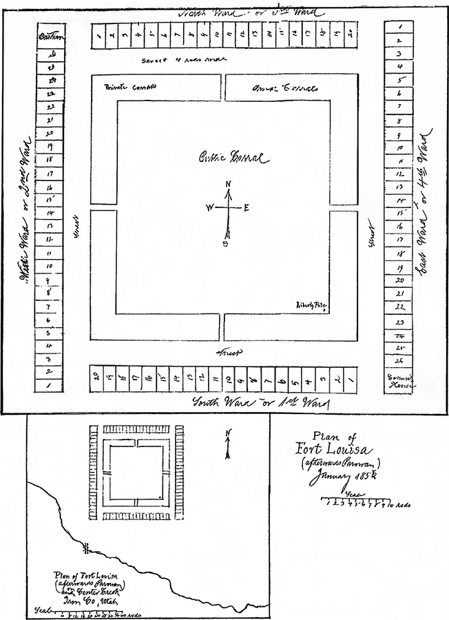
On Tuesday, George A. Smith met with surveyor William H. Dame and his crew to plan the fort survey and put the crew to work (see illus. 3-1). Groves and Lee were “stakes men,” George Brimhall and Chandler Holbrook “chain carreers [carriers],” Isaac Barnard a “staff man,” and William A. Morse a “stake maker.” Morse and Isaac Newton Goodale numbered the lots.50 James Lewis selected one man from each 10 in the 1st and 2nd 50s to guard the camp and stock, since on the previous day Peteetneet and his men “hung about our camp all day in considerable numbers.”51 Late Tuesday afternoon, Tarlton Lewis and crew returned, reporting that the timber was cut and showing a “small” sample, two feet in diameter.52
Illus. 3-1. Dame’s first survey (1851) of Fort Louisa (later Parowan). See app. 3 for list of lot owner assignments in Fort Louisa. This plat is furnished for information only. No liability is assumed by Assessor’s or Recorder’s Office as to correctness of such data. Iron County Recorder.
Surveying the fort site was the beginning of a sustained crescendo of activity, from building the road into the canyon, cutting and hauling timber for the council house and bastion, damming Center Creek and digging a two-mile irrigation ditch east of the fort site to erecting a blacksmith shop and making charcoal, building a sawmill in the mouth of the canyon, making and operating grindstones, raising a liberty pole, surveying farm lots, guarding the camp and stock, quarrying rock for the council house chimney and constructing a bowery and wickiup for a temporary school and meetinghouse. Lee describes how the survey team “gathered up their surveying apperatus & went on the ground[;] the committee establish[ing] the corners of the fort” as follows:
The Fort was laid out 56 rods square, with a square in the center of 40 rods, for a public carrall, with a street 4 rods wide around the square with 4 large gates opening north & south 2 on each line, on the south east corner 4 rods square of ground is reserved for a Council House to be built 45 by 22 feet with recesses one on each side of 12 feet deep forming a bastion on that corner; & on the N. W. corner 4 rods are also reserved for a bastion, & around this square are laid out in lots 2 rods by 4. 26 lots on the 2 E. & W. lines & 2 on the 2 N. and S. lines making 92 lots in all.53
In other words, the fort was laid out on a square, each side of which measured 924 feet (308 yards). It had an interior square, the sides of which were 40 rods, containing 10 acres. This space was also used as a public corral. A four-rod inner square (66 by 66 feet) was reserved in the southeast corner of the public square for a flagpole and small assembly area. Between the inner square and the houses was a street four rods wide (66 feet or 22 yards). The back wall of each house, by forming the outer perimeter of the settlement, became, in effect, the fort wall.
There were four gates, located two each on opposite sides of the north and south walls. A bastion was planned for the northwest corner and a council house (which could also serve as a bastion) for the southeast corner. From atop these two buildings, lookouts could command all approaches to the fort in an unbroken line of sight. Small individual lots formed the interior perimeter of the fort, each facing the public square. The whole plan allowed symmetrical division into four wards. The first ward consisted of 20 lots on the south (later Block 11); the second included 26 lots on the west side (Block 16); the third covered 20 lots on the north (Block 13); and the fourth included 26 lots on the east (Block 6). This totaled 92 lots, each measuring two rods by four rods.54 These dimensions mean that individual lots were only 33 feet by 66 feet, certainly not big enough to accommodate a large house, corral, barn and garden each.
The survey was finished on Wednesday, 22 January; that evening, house lots were assigned to members of the camp (see app. 3). Since Lunt refers to the completion of the “Fort Plot” survey on this date, we can be confident that these were house lots, not the farm lots outside the townsite proper. On 23 January, Lee writes, referring to George A. Smith, that “Last evening the Pres had the camp collected togather & dealt out the lots to them as long as any man wanted one[.] all taken but 2 lots on the east line there being no demand for them the Pres said he would take them.”55 It was common practice at this time to parcel out land by drawing lots at random. Unfortunately, no comprehensive record of these and the related farm lot allocations has survived. A search of titles and abstracts reveals names and lot assignments of some original settlers, but the list is incomplete. The Deseret General Assembly had passed an ordinance dated 2 March 1850 requiring all county recorders to procure suitable record books, but the first official records of city lots in Fort Louisa were not made until June 1851 (see app. 3), and official county recording was not required by the territorial legislature until March 1852.56
Neither Smith nor Lee documented the garden spaces outside the fort boundaries assigned to each family, although drawings and paintings of the fort clearly show them on the east, south and west sides (see illus. 3-2). Presumably, there were spaces on the north side as well. Each settler probably had a narrow, 33-foot strip directly behind his fort lot. The only written documentation supporting these strips is a list of garden plots recorded in the front of Deed Book B,57 as follows:
Assignee
Lot
William A. Morse
1
J. D. Lee
2
B. Watts
3
F. T. Whi[t]ney
4
L. Lewis
5
E. Whipple
6
J. L. Robinson
7
C. Holdbrook
8
E. H. Groves
9
Walker & Parks
10
Brown & Goodale
11
S. Johnson
12
M. Carruthers
13
The Council House and the Bastion
Public projects took precedence over private buildings. Among the former were the council house, bastion, public corral, irrigation canals and, to some extent, the sawmill. The council house was the most important of these. The University of California’s Bancroft Library manuscript, “Early Records of Utah” describes these structures as follows:
During the year the settlers at Parowan built a fort, the houses being on the lines and the intervening spaces being filled with pickets, ten feet high. On the southeast corner of the fort a meeting house, in the form of a St. Andrew’s Cross, was built of hewed logs, which projected sixteen feet over the lines, so as to form a bastion, and completely commands two sides of the fort. On the opposite or northwestern corner a pentagon bastion was erected of logs, so as to hold a cannon, and thus command the other two lines. The stockade of the public corral was built two feet in the ground and six feet above.58
In her History of Iron County Mission, Luella Dalton describes this building’s uses and remodeling over some 15 years, enabling us to get a glimpse of the central place it held in community functions. Dalton’s commentary is based on the reminiscences of Heber Benson:
In the southeast corner of the Old Fort, a four rod square was reserved for building a Log Council House and on the 26th of February, 1851, the foundation was laid. This building stood a little north of where Alvin Benson’s home (Elmer Lowe’s) now stands [35 East 100 South], and was the first building to be started in the valley. The main building was 22 by 44 feet with two recesses twelve feet deep and sixteen feet long on the east and west sides. It was built of hewn logs and timber, the roof being covered with slabs and dirt. As soon as the shingle mill started up, the roof was raised a little making a large classroom above the auditorium and a fine substantial shingled roof covered the building. There were steps at the north and outside of the building leading to the upper classroom, which was used as a meeting room for the Priesthood quorums. The building was heated by a large fireplace in the south end. The two recesses on the east and west were used for classrooms.
A stage was built in the north where the pioneer plays were produced for many years. Plays were put on here in 1851 by the Parowan Dramatic Association with Edward Dalton as President. The first plays were put on with quilts and blankets for want of curtains and scenery.
The Old Council House was built for a bastian with portholes at every corner and in case of Indian attack it was large enough to hold the whole colony, but fortunately it never had to be used that way. It was built so it could be made into five large classrooms, by using canvas curtains and when drawn it was a fine big auditorium with a moveable pulpit in the center. It served as the Community Center for many years until about 1867, when the basement of the Old Rock Church was completed.59
Three different dimensions are given for the main structure. Lee reports the size, not counting “recesses,” as 22 by 45 feet, while Dalton gives both 22 by 44 and 25 by 45 feet.60 Nor is the completion date known. Lee’s diary, which ends on 11 March 1851, does not mention the building’s completion. George A. Smith’s journal records meetings “at” (but not “in”) the council house on 25 March and 16 May 1851.61 His first reference to a meeting “in” the building was on 25 May 1851, nine days after the end of Brigham Young’s first visit to the area.62
The bastion, important to the security of the community, was located on the fort’s northwest corner. It was “laid with 5 Corners, logs 14 feet long,” suggesting it may have been only about 14 feet square.63 Fort Utah (Provo) had been built with a raised platform in the center for its cannon, enabling the weapon to fire over the walls in any direction but without allowing it to protect the area immediately adjacent to the fort. In contrast, the Iron County bastion’s location enabled it to sweep the entire north and west approaches to the fort, while the council house guarded the east and south walls. No other description of the bastion is available. Perhaps a ramp allowed easy placement of the cannon; but since the weapon was small enough to be disassembled and carried in a wagon, a ramp may not have been required.
“Large Sticks of Timber”: Building the Sawmill
Another public works project was a sawmill to provide finished timber. On 6 February 1851, work began on the public water ditch. The same day, 20 men “commenced cutting and sawing the timber for the mill.” On 7 February, carpenter Richard Benson began operating a pit saw (also called a whip saw) to cut timber for gears for the sawmill. The single blade, five to 10 feet long, was usually operated by two men, one astride the log and the other in a pit below. A more sophisticated version of the tool could be driven by water power.64
Apparently encouraged by Benson’s activity, Smith predicted two days later that “the timbers for the mill should be got out this coming week,” continuing that “the necessity of a mill is imperiously felt by all at the present. The mill can be put in opperation within 4 weeks time without injuring any man. There are men who are not ready to plough, that might spend a few days on the mill just as well as not.”65
On 10 February, Smith borrowed a horse and rode up the canyon for five miles, personally locating a mill site about three-quarters of a mile from the fort. That same day, he “engaged hands to get out the timber for the mill” frame.66 According to Luella Dalton, this was “just below the old Lime Kiln on the right hand side of the canyon, after you cross the Mill race going up.”67 A mill appears there on William Dame’s 1853 Parowan plat. Richard Benson, one of Parowan’s older citizens and descendant of pioneer Richard Benson, showed Morris Shirts the site in 1980. The pit depression and millrace are still faintly visible.
Between mid-February and the beginning of May, Smith oversaw cutting and hauling timber for the mill, raising the frame and installing the machinery. On 20 February, workmen made a tailrace by rechanneling the creek; on 19 March, Burr Frost finished the mill crank; on 8 May, the mill “sawed four boards,” just two days before Brigham Young arrived on a tour of inspection. Smith writes that the mill sawed 613 feet on 21 May and 750 the next day.68
President Smith formally petitioned the city council “for a Mill Priviledge” on 24 May,69 and on 2 June was “Granted . . . the controll of the timber grass and Mill power in Center Creek Kanyon . . . [and] the privillidge of a Saw & Grist Mill on Center Creek.”70 Smith, who intended to operate the mill as a private venture for the public good, had previous experience with mills. In the Salt Lake Valley, he was in partnership with Archibald and Robert Gardner at West Jordan in a gristmill and had sawmill and timber rights in the Oquirrh Mountains west of the Jordan River.71 With Smith’s background, it is no wonder that he took such a personal interest in the Center Creek mill project. Smith used public labor to build and operate the mill until Brigham Young established a city government in Parowan apart from the ecclesiastical organization, at which time Smith began to hire laborers. (The Gardner mills in West Jordan were unambiguously private enterprises. The owners hired builders and millhands and charged the pioneers for their flour and lumber.)
The June reference to a gristmill raises interesting questions. While the various journals contain over 80 mill references between the settling of Parowan in January 1851 and the end of September 1852, only eight can be connected to gristmill (as opposed to sawmill) operations. One is the granting of Smith’s gristmill privilege; the second reports Samuel Gould’s arrival from Salt Lake City with “one milstone”; the remainder refer to the grinding of wheat. None makes any mention of constructing a gristmill separate from the sawmill or of setting some part of the sawmill aside for grinding settlers’ wheat into flour. Yet the Deseret News of 29 November 1851 prints a 5 November letter from George A. Smith noting that “Our saw and grist mills are in sucessful operations.” The exact relationship between the two types of mills remains unclear in the journal references.72
A “Pleasant and Lovely Location”: Fort Naming and House Building
Within a month of arriving at Center Creek, a decision had been made to name the place Fort Louisa.73 John D. Lee mentions the name as early as 26 January when he writes of strolling with his two wives, Polly and Lovina, and with George A. Smith and his wife Zilpha “to the plat of the fort Louisa” after Sunday morning meetings. A choir, under Robert Wiley, had been organized to provide music for worship services and improve morale. Many members of the camp, unfamiliar with the English tunes Wiley chose, avoided choir practice. On 26 January, George A. Smith responded by appointing Almon L. Fulmer and Thomas S. Smith to set up an American choir. To keep peace between the two choirs, Smith alternated their performances.74
Apparently “Fort Louisa” was not adopted as the fort’s official name until Sunday, 9 February. In an entry datelined “Iron County Mission at Louisa, Deseret,” John D. Lee gives George A. credit for the name: “The Pres . . . [s]aid that we had laid out a city & he being a particular favorite of the ladies gave it the name of Louisa.”75 George A. Smith’s journal entry for the day confirms that “the Brethren assembled for meeting on the lee side of the Meeting House. Organized ourselves into a Branch named Louisa Branch, I was chosen President.”76
On 31 January, Smith allowed the men their first day off from public works to begin building their own homes, probably because the men working on the council house had run out of logs.77 With characteristic wit, Smith describes the rush to fell timber:
[T]heir was a regular Stampede for the Kanyon every man takeing his ax and leaveing his gun, their was not half a dozen men about the Camp during the day. Every accessible tree that would make a house log within 4 miles stood a slim chance today.78
According to Lee, Smith thriftily assessed each eager home-builder one 14-foot log for the bastion.79 Lee’s account also includes Smith’s half-scolding counsel to the men before they left the camp:
There will be a general rush for the timber & I do not want any particular restrictions or liberty given to any man but to do right that is liberty enough for any man, to slash down any great quantity of timber would not be very prudent nor run over it & tangle it about would not produce good feelings. Within ½ hour after the liberty was granted the road was lined with chopers . . . 4 o’clock p.m. would have astonished any set of men (but Mormons) to have seen the havock that had been made within 6 hours time only. There must have been at least 1500 house logs & as many poles.80
In addition to getting in each others’ way and stacking timber in the paths, there had been an accident. Thomas Cartwright chopped into his foot, severing one toe entirely and badly cutting two others.81 Then on 5 March, Joseph Millet “cut off about half of his big toe in scoreing timber.”82
Smith himself had prudently avoided the canyons, first to write a letter to Brigham Young for delivery by a small party of Mormons traveling from California to Salt Lake City83 and then to borrow a plow and turn over a quarter acre—the first furrow turned in Iron County. He then sowed wheat, peas, carrots, parsnips, radishes and mustard seed.84
A few people moved onto the fort lots on 4 February but the majority—89 wagons—moved Wednesday, the fifth. “The bustle was about like May day in New York,” recalled Smith.85 The temperature was a balmy 70 degrees in the shade.86 A week earlier, Smith had advised the settlers that “it would be well to commence putting in our wheat.”87
They lifted their wagon boxes off the running gears and formed them into a square on the fort’s interior, using their canvas as roofs and heating the interiors with stoves. Some used tents until more permanent houses could be erected. Edson Whipple’s journal entry says: “arranged my wagons and put a tent in front of one of them.”88
On 6 February, Job and Charles Hall completed the first log house in the fort. Perhaps because of his administrative duties, Smith needed considerable help completing his own house. On Monday, 17 February (his sole venture into the canyon to haul logs, no less), his team took fright and ran away, knocking the wagon to pieces.89 By 4 February, he had laid out the foundations for two houses (presumably on his two eastern lots); by his own record, he laid the foundation for one house on 10 February.90 On 12 February, Smith records that four men hewed logs for him. Two days later, Herman Bayles helped Smith raise two rounds of logs. On Sunday, 2 March, Bishop Miller of the Third Ward (north side) suggested that the men help Smith. The next day, seven of them hauled logs from the canyon for him; on 4 March, Robert Wiley quarried rock for the chimney, which Joseph Millett and Peter Smith (Dibble) hauled to the house. The same day, four men worked all day, three more working half a day, while an eighth man worked an hour in the evening. On Sunday, 23 March, 10 men volunteered to finish Smith’s home; five finished raising it on 28 March, while two more made the window sash, frame and door.91 Smith makes no mention of paying anyone, so presumably this labor was all volunteer. His entries also do not specify how much labor he himself contributed to the project.
On 3 April he records, “The brethren at my request moved my waggon beds to the side of my house.” He apparently slept in one, for nearly a month later, he records being awakened by a cry in the night from Ruth, his four-year-old Indian foster daughter. Going “into the house” he discovered that her bedding had caught fire, but she was miraculously unhurt.92 Such moments give the flavor of settlement life. While belatedly packing their belongings, for instance, to move from Center Creek camp to the fort on 5 February, Ebenezer and Phoebe Brown were suddenly startled to see a large wolf within a rod of them. Ebenezer seized his rifle and shot it. Smith and Peter Shirts stood guard that night, but there were no further incidents.93
When Nephi and Sixtus Johnson erected their log house a little over the fort line, about 40 men with hand spikes gathered late on Sunday, 16 February, to move the house back into line—without informing the Johnsons. Young Joseph Millett threatened to shoot the first man to touch the building. Richard Benson and David Brinton disarmed him. George A. Smith grabbed Millett, “shook him and throwed him on the ground which hurt him more than what I intended, and told him to go off to bed and never threaten to shoot again.”94 In unloading the gun, Smith discovered that it had wadding but no lead. He then ordered everyone to bed, advising them that the Sabbath was not a good time to move the house. A few nights later, at his request, the house was put in line “but few that was in the first Co assisted in the last opperation.”95
Such frustrations could be expected, given the long days of labor typical of frontier living conditions. For the most part, however, the iron missionaries had pulled together remarkably well, putting community welfare first. They had erected basic housing and provided for defense. Now farming would engross the community for most of the growing season.
Sidebar 3-1: First Elected Officials in Iron County
Representative:
Jefferson Hunt
Associate justices:
Elisha H. Groves Edson Whipple
County recorder:
James Lewis
Sheriff:
James A. Little
Assessor and collector:
Joseph Horne
Supervisor of roads:
Almon L. Fulmer
Magistrates (justices of the peace):
Anson Call John D. Lee Aaron Farr Tarlton Lewis
Constables:
Zechariah B. Decker Charles Dalton Samuel A. Woolley Charles Hall
Sealer of weights and measures:
Phillip B. Lewis
Sources: Lee, Iron Mission journal, 17 Jan 1851; Lunt and Lunt, Lunt,diary, and Smith, Parowan journal, on the same date. These entries agree on the personnel named, but spellings differ in Lunt. He gives Edson Whipple as “Edwon,” Joseph Horne as “Horn,” Zechariah Decker as “Z.B.” and Phillip Lewis as “Philip.”
Notes
1. See discussion of Camp 25 in ch. 2 (Sunday, 12 Jan 1851).
13. Ibid.; Gibson’s arrival in Salt Lake City on 29 Jan 1851 was the first word of the appointment to reach the territorial capital. See Whitney, History of Utah, 1:452.
14. Lee, ibid., 14 Jan 1851. Gustive Larson, p. 273, n. 47, identifies the “smawl” lake as Rush Lake.
15. Lee, ibid., 15 Jan 1851; Smith, journal, 15 Jan 1851. The quote is from Lee.
16. A geological feature called the Rim of the Basin falls across southern Utah south of Cedar City. Acting to some extent as a minor continental divide, this landmark creates a watershed in which creeks “above” it flow north, while creeks “below” it drain south. With Coal Creek lying above the Rim, Dame’s party, while heading downstream, would still have been traveling in a more or less northerly direction.
17. Lee, journal, 15 Jan 1851; Smith’s copy of this entry, made on the same date, includes the clearer phrase: “specimens of the ore rock we brought to be tested.”
24. Lee, journal, 16 Jan 1851 (where Charles and John’s surname is spelled “Dolton”); Smith, on the same date, records a somewhat different version.
25. Lee, ibid. The implements in Hunt’s cache would have been of great value to the settlers. Unfortunately, as Smith reports on 7 Feb 1851, when he and Thomas Wheeler rode out to Summit Creek to retrieve them, the cache was empty. No further references to the small mystery have been found.
26. Lee, journal, and Smith, journal, both on 16 Jan 1851.
32. There are several versions of the history of this cannon. According to Louella Adams Dalton, the cannon was a “war prize” from Missouri, hidden in the mud by Missourians after the battle of Crooked River near Far West. An old sow and her piglets, rooting around, partially uncovered it. The Mormon militia dug it up, cleaned it, mounted it on wheels and took it to Nauvoo, then to Salt Lake City. It is not known how the decision was made to send the cannon to Iron County with George A. Smith in 1850–51. During the time it was in Parowan, it was known as the “Old Sow Cannon.” At some point, Dalton claims, it was returned to Salt Lake City. (It may be the cannon formerly on display at the Temple Square Bureau of Information and now housed in the LDS Church Museum of History and Art.) See Dalton, Iron County Mission, 12. See also “Cannon Being Memorialized Has Colorful Pioneer History,” Church News, published by Deseret News, 29 Jan 1994, 7, 13.
33. Smith, journal; Lee, journal; Lunt, diary: all on 17 Jan 1851.
39. Lee, journal, 18 Jan 1851, notes the “carall” being built on the west side of Center Creek; Lunt, diary, on the same date, records forming the wagons “in two lines on south side of Creek near the liberty pole.”
40. Lee, ibid., 19 Jan 1851; Smith, journal, on the same date, writes that the “Camp . . . listened to a very interesting discourse from Anson Call, to which I bore testimony.”
45. Anonymous, “Iron Mission Record,” 1850–59, entry of Sunday, 19 Jan 1851, 6th and 7th pages. Descriptive title given by Morris Shirts to holograph (undated, unpaginated, untitled and missing the first page or pages) at the LDS Church Archives. The record begins mid-entry: “last season about two feet higher.” The next entry is Monday, 23 Dec 1850, the last daily entry being 16 Feb 1851, with weekly (or longer-interval) entries until 1 Jun 1851. The final 28 pages, probably incomplete, consist of birth, marriage, excommunication and death entries in various hands, the last entry being 28 Sep 1859. Author tentatively identifies the diarist as James Lewis because known samples of his penmanship compare favorably with the writing here and because he was clerk for both the “traveling branch” of the Iron Mission and the “Louisa Branch” organized in February 1851. The MS is 52 pages long, 19½ of diary entries and 32½ of vital statistics. It was donated to the LDS Church Archives by G. Homer Durham in 1977, with no record of where he obtained it.
47. Ibid. These three were members of the Council of Fifty, a prestigious group of trusted leaders organized in 1844 by Joseph Smith to serve as a legislative body for the theocracy established in Nauvoo. It met periodically to advise and enact “shadow” legislation until Utah became a territory in 1851. Leonard J. Arrington, Brigham Young: American Moses (New York: Alfred A. Knopf, 1985), 109.
54. Ibid.; general references in Smith, journal, 21–22 Jan 1851.
55. Lee, journal, 23 Jan 1851; Smith, journal, 22 Jan 1851. Both men record the lot drawing as having occurred on the 22nd. See also Lunt, diary, 22 Jan 1851.
57. Deed Book B (28 Feb 1855–15 Sep 1863), Iron County Recorder’s Office, Parowan, Utah. The list appears on the torn flyleaf page in the front of the book.
58. Knecht and Crawley, Early Records of Utah, 112.
63. Ibid., 22 Feb 1851. Compare the phrasing of Lee’s journal entry on 21 Jan 1851: “on the south east corner 4 rods square of ground is reserved for a Council House . . . with recesses one on each side of 12 feet deep forming a bastion on that corner; & on the N. W. corner 4 rods are also reserved for a bastion.” It is not possible to tell, by collating the journal entries, exactly what size the leaders intended the bastions to be.
64. Lee, journal. Lee gives two sizeable entries the same date: “Sund. Feb. 9th 1851.” The water ditch and pit saw references come near the end of the first of these, whose internal references show that it actually covers 3 Feb through 8 Feb.
65. Ibid. This cite occurs near the end of the second passage Lee dates as “Feb. 9th.”
68. Smith, journal, 20 Feb, 8 Mar, 19 Mar, 8 May, 21 May and 22 May 1851.
69. Ibid., 24 May 1851. Smith had already petitioned the territorial legislature for these privileges by letter on 17 Jan 1851, which Jefferson Hunt carried north on his return to Salt Lake City.
71. Laws and Ordinances of the State of Deseret (Utah), Compilation 1851 (Salt Lake City: Shepard Book, 1919), 16–17, microfilm copy, series 83238, reel 1, Utah State Archives and Records Service, Salt Lake City.
72. Smith, journal, 26 Jun, 1 Aug 1851; George A. Smith, letter to editor, 5 Nov 1851, in Deseret News, 29 Nov 1851, 3d unnumbered page; James Whittaker Sr., journal, 12 Nov 1851, catalogued as no. WH-1–2, SUU Archives (note that James Jr. occasionally records entries in this journal). Note additional mill references in Lunt, diary, 4 May, 16 Jun, 17 Aug and 9 Sep 1852.
73. Lee, journal, 9 Feb 1851, and Larson’s prior comment, at p. 364, n. 16. The origin of the fort name is not clear. None of the 30 women in the first company was named Louisa. John D. Lee implies that the fort was named in honor of Louisa Beaman, first plural wife of Joseph Smith (although there are indications that other women may have preceded her). Louisa’s fairly recent death, on 16 May 1850, may have prompted George A. Smith to think of her when searching for a fort name.
75. Ibid., 9 Feb 1851. (The quote is taken from the second section so dated.)
76. Smith, journal, 9 Feb 1851 (mislabeled “Jany” in original). This “branch” should not be understood as equivalent to a twentieth-century branch (one unit smaller than a ward). Lee’s journal entry of 9 Feb (the second so dated) reports that, immediately after the settlers agreed to name their fort “Louisa,” they “laid out the city into 4 wards . . . & Bishop A. Call is a resident of the 1st ward. Bro. Tarlton Lewis of the 2nd[.] D.A. Miller of the 3rd & Bishop Jos. L. Robbinson of the 4th. J. D. Lee motioned that the above named persons act as Bishops in their respective wards the vote was taken sepperately & carried.”
83. Ibid., 28 Jan 1851; Lee, journal, 27 Jan 1851. The six men—William P. Goddard, Gordon S. Beckstead, Jacob Winters, Henry Cook, William Bird and James Davidson—were traveling to Salt Lake City with another letter for Brigham Young, this one about the proposed purchase of the Williams Ranch near Cajon Pass in California.
88. Whipple, journal, 5 Feb 1851. The whole reference from Whipple is: “This morning most of the camp moved. Some remained on the ground. Bro. Hulse and I got our wagons over, and he hauled a load of stone for underpinning my house, and I arranged my wagons and put a tent in front of one of them.”
90. Ibid., 10 Feb 1851; Lee, journal, 7 Feb 1851 (misdated “Frid. The 4th” inside already-misdated “Sund. Feb. 9th 1851” section).
91. Smith, ibid., 12 Feb, 14 Feb, 2–4 Mar and 23 Mar 1851. On 24 Mar, Smith wrote that that “Br [John P.] Bernard and [William] Empy presented me with a hewed log house.” The reference does not clarify whether this log structure was another house Smith had arranged to buy or trade for, or whether the two men had, on that date, finished construction work on his initial home.