After providing shelter, the next most important task facing the new community was assuring a food supply. The colonists would need to decide where to locate their farms, how to fairly distribute the farm lots and exactly when to begin planting. With these specific tasks well underway, the iron missionaries could then turn their attention to more general affairs, such as building a meetinghouse, establishing a school, exploring for fuel and accommodating new arrivals.
Most likely, the settlers were able to begin producing spring vegetables in their garden plots by April. These plots, as noted in chapter 3, were located outside the fort but near the walls1 (see sidebar: “Planning a City of Zion”). Typical of this early stage in Utah colonizing, the Mormons also planned a “big field” or communal farm. Settlers were assigned lots within these large parcels of arable land. The whole was then surrounded by a fence that was collectively maintained. Having all the farm allotments in one location improved efficiency; having a constantly maintained perimeter fence improved security. However, the initial process of locating these farm lots caused a serious division of opinion among the pioneers.2
Locating the Farms: Black Soil or Sandy Loam?
The settlers had their choice of two distinct soil types in the region. In the valley below and west of the fort, nearer the lake bed, grew thick wire grass in black soil, called the “bottom land.” Closer to the fort on the uplands of the bench was sandy loam, the “bloody red soil” that had so displeased some of the men.
George A. Smith opened the discussion on Sunday, 26 January 1851, about 10 days before the planned move to the fort site. The camp met for worship around 1:30 p.m. After the service, Smith stated that “he would resolve this meeting into a legislative capacity (especially) for the committee to express their views & bring up their strong reasons in favor of the best spot to locate our farming interests this present season.”3
John D. Lee’s journal notes the vigor of the debate. Elisha H. Groves wanted to farm the upland near the fort because he thought it would produce just as well as the bottom land but with less labor. Anson Call warmly disagreed, saying he would rather have one acre of wire grass land than four of the upland because the yield would be so much greater.4 Unfortunately, Lee reports no other opinions in this entry. However, the “Iron Mission Record,” presumably penned by James Lewis, does. The statements documented there clearly demonstrate the eagerness of camp members to share in decision-making. For instance, Andrew Baston, 44, a farmer from Maine, wanted to accommodate everyone by having two fields, but Almon L. Fulmer, the 34-year-old newly elected road commissioner, wanted to work together on one field, saying the cattle were weak and already had too much work to do. Dr. William A. Morse, at 64 one of the oldest of the pioneers, agreed, saying “One field. Union is power.” Edson Whipple was willing to farm either bottom or upland, though he preferred upland “for this season,” but hoped it would be on the south side of the creek.5
After a dinner break, the settlers reconvened at 6:00 p.m. William H. Dame, who had led an exploring party west toward the lake, following the creek on the north side and returning on the south side, said he liked the low land, but ultimately preferred the upland by the fort, thinking it best “to farm as near home as possible.” A “Bro. Miller” expressed a preference for the bottom land “for this season” since it would require only a third of the water necessary for the upland and had fewer crickets. Elisha Groves agreed that the bottom land was best, but questioned whether farming there would be “best for the present season.” He felt crickets were likely anywhere, but since one man could farm more upland in a day than two could on the bottoms, the fort would be better protected by a big field closest to it.6
Vermont farmer Joseph L. Robinson, 49, had earlier voiced his preference for the “very handsome” bottom land, but now seconded Lee and Baston’s proposals for two fields, each settler to have an allotment in both. The energetic debate continued, but neither position gained on the other. Having heard all the opinions, George A. Smith wanted more time to consider, finally announcing “I shall study the best interest of the camp.”7 Following a short break, talk resumed around a large campfire. In Smith’s words, they “continued the discussion very spiritedly until about Ten oclock.”8
The initial debate had focused on which type of soil would produce the best crop. John D. Lee, however, in the afternoon meeting, raised an equally important point—that not all the settlers had the right tools or sufficient experience to farm the wire grass land on an equal footing. He urged that the “interest of all . . . be considered togather & not the building up of one or a few individuals.” The conclusion of his 26 January journal entry underscores his wish to apply the spirit of compromise to a decision affecting the survival of the whole company:
the wire grass land is a first rate soil & no man can prise it higer than he does but the question now resolves its self in this shape, among this co. are farmers blacksmiths, carpenters, shuwmakers, tailors, stone & brick masons silver smiths & portrait painters etc. Some have good ploughs & strong teams & could manage the wire grass land to a good advantage, to such it would be proffetable but a great many have poor ploughs & weak teams & some no ploughs at all—& what is still worse than all they lack experience, to that class it would be very unproffitable to engage in the tough hard sod this present year. But could we so manage it as to unite our interests & have a portion of both kinds of soil to cultivate this present season it certainly would better accommodate the whole & would be in my opinion the best policy.9
Deliberations continued for the next several days, but by 31 January 1851 lots were being surveyed and allocated. On that date, Smith says, William Dame “surveyed 30 5 acre Lots, 5 of which he condemned” on account of greasewood and sage. Later that evening, around a large campfire, “their was about 50 applications for 5 acre Lots and about 20 for 10 acre Lots.”10 John D. Lee’s entry for the same day reports that “the surveyor commenced surveying the 5 acre lots to accommodate the whole camp with a small piece of land nearby for vines[,] potatoes and garden stuff.” Later in the entry, however, Lee states that only “about 6 persons applied” for the 5 acre lots, another instance of the journals being less than consistent on this subject.
“Shooked Up Togather”: The First Draw for Farm Lots
The inconsistency between Lee and Smith on lot allocations points out the whole problem of where the five-acre and 10-acre lots were located. Smith’s entries generally imply that five-acre lots were located on the upland near the fort, while 10-acre lots were located on the wire grass or bottom land some two to three miles away. Lee, however, in one entry, claims the exact opposite. On Sunday afternoon, 2 February, at a further allocation of lots, he notes that “Names were then taken & the amount of land wanted to the amount of about 300 acres of upland in 10 acre lots & near the same amount in 5’s of the wire grass something over 500 acres were petitioned for.”11
By closely examining both journal references and Deed Book A entries we can clarify the issue. On the evening of 2 February, the five-acre lots were distributed, each being numbered by a stake placed in one corner. The name of each man who applied for a lot was placed on a ticket, and the tickets were tossed in a hat, shaken together and drawn out by Bishop Groves. Lot 1 was automatically assigned to George A. Smith. The first man whose name was drawn took Lot 2, the next man took Lot 3 and so forth until all the names were drawn. The surveyor and clerk were on hand to record the lot number and corresponding range and block assigned to each man.12 As early as 9 February, President Smith (according to Lee) noted that 550 acres of wire grass and 1,000 acres of upland had been applied for when there were “only about 550 bushels of seed wheat in camp” along with some oats, corn, barley and potatoes. He scolded overambitious farmers, saying
it is not good policy to overcrop ourselves—there is a great deal of work to be done always in the settlement of a new place more than what many are aware off [sic]. A small crop well tended is better than double the amount of land run over & half tended.13
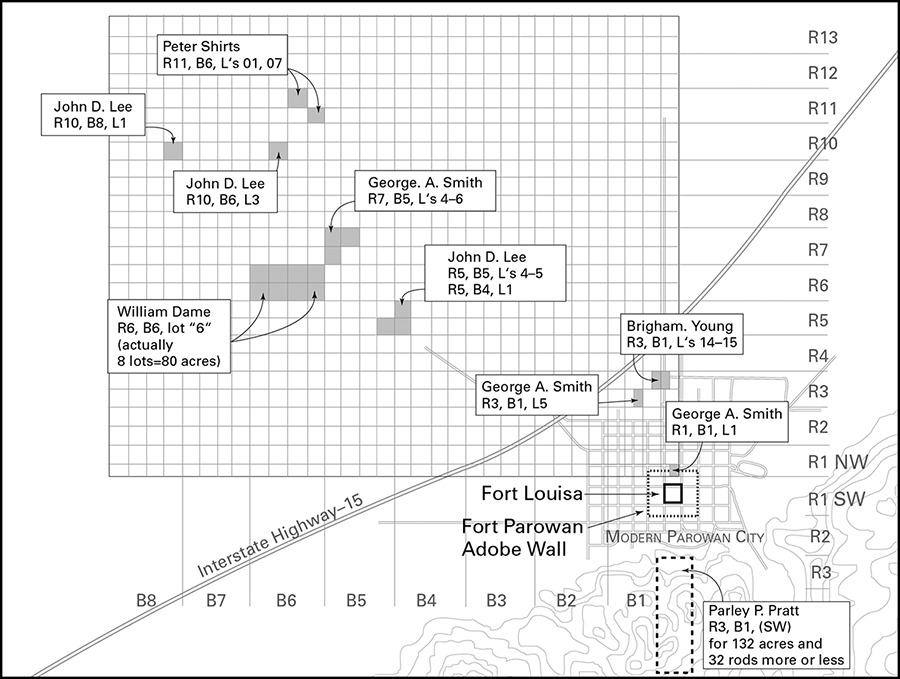
Apparently, not all the settlers who claimed land in early drawings officially recorded their property. Some transactions are known to us primarily through journal references. William Dame, for instance, took 80 acres near the stream bed where water would have been easily obtained. (As surveyor, he may have had privileged selection of lots since his “salary” was in acreage, as was the custom of the day.) George A. Smith had a farm adjoining Dame’s that he refers to on 10 March, writing that “Thos Wheeler and Peter Smith (Dibble) took my seed grain, plough and drag, two yoke of cattle and Wheeler’s horses and went down on my farming land, a piece which Dame surveyed me, 20 acres, about 2½ miles distant.”14 And on 12 April, heading for the Pacific Islands with a group of missionaries, Parley P. Pratt asked William Dame to survey a piece of land for him on the mountainside south of the fort. This day was also Pratt’s birthday, which he celebrated by sharing a “sumptuous repast” with 10 or 12 others at George A.’s house. Pratt’s new land included some valuable springs and range land but not much farm land. It was gigantic by 1851 standards—84 by 240 rods, a little over one-quarter mile by three-quarters of a mile, or 130 acres15 (see illus. 4-1).
Illus. 4-1. Early Parowan farm allocations, reconstructed from records in Iron County Recorder’s Office, showing representative range (R), block (B) and lot (L) designations.
But even these helpful descriptions do not resolve Smith and Lee’s journal inconsistencies over how the five and 10-acre lots were distributed between upland and wire grass land. To answer that, we must review the earliest transactions found in Deed Book A. One insight into local geography that helps us understand the deed book entries is knowing that the change from wire grass soil to upland more or less followed the old river channel of Center Creek, west of Parowan City (in the neighbor-hood of the first five blocks or so of Range 4 or 5 North). By organizing the list of entries according to the range in which the respective blocks and lots are located, the problem quickly resolves itself:
Selected Lot Listings from Deed Book A
Date
Owner
Range
Block
Lot
Acres
07 Feb 1851
George A. Smith
1
1
1
5
[11 Apr 1851?]
Thomas Corbitt
1
1
4
5
24 Feb 1851
George Brimhall
1
1
9
5
07 Feb 1851
Francis Whitney
1
1
16
5
16 Mar 1851
Elisha H. Groves
2
1
4
5
11 Apr 1851
William Mitchell
2
1
6
5
27 Feb 1851
Philip Lewis
3
1
10
5
24 Feb 1851
Zedick Judd
4
1
11
5
16 Mar 1851
Elisha H. Groves
4
1
13
10
11 Apr 1851
William Mitchell
5
1
4
10
07 Feb 1851
James Lewis
5
1
8
10
24 May 1851
George A. Smith
7
5
4
10
24 May 1851
George A. Smith
7
5
5
10
24 May 1851
George A. Smith
7
5
6
10
24 Feb 1851
Zedick Judd
8
6
1
10
24 Feb 1851
Zedick Judd
8
6
8
10
16 Mar 1851
Jefferson Wright
10
6
1
10
24 Feb 1851
George Brimhall
10
7
2
10
27 Feb 1851
Peter Shirts
11
6
1
10
27 Feb 1851
Peter Shirts
11
6
7
10
Source: Deed Book A, Iron County Recorder’s Office, Parowan, Utah.16
It appears, even from this incomplete list, that most if not all upland lots were surveyed at five acres, while wire grass lots were surveyed at 10 acres. That Range 4 is the only location on the list showing separate records for a five and 10-acre lot each merely confirms our expectation that somewhere in that vicinity, soil type shifts from sandy upland loam to heavier, darker wire grass sod. Finally, the list tells us that Lee’s journal entry of 2 February, noting 10-acre upland lots and five-acre wire grass lots, is almost certainly an error, most likely an inadvertent transposition of what he intended to write.
“The Frost . . . Is Out of the Ground”: Sowing Early Crops
The first planting season was difficult, although it started well. As early as 30 January, Smith wrote “The frost in some places is out of the ground sufficiently to plough.” The next day (the same day Dame surveyed the five-acre lots), Smith records that he “borrowed a plough and with the assistance of Peter [Smith (Dibble)] ploughed ¼ of an Acre of land on a 5 Acre Lot.” John D. Lee draws a more important conclusion to Smith’s experiment, saying “the Pres. with his own hands held the plough to make the first furrow that ever [has] been made in Iron Co to our knowledge, & sowed some wheat.”17
On 3 February 1851 Anson Call, Joseph Robinson and Daniel Miller (the committee assigned to investigate fencing the wire grass field) gave their report. They concluded that in some places Center Creek would itself be a sufficient fence to restrain the cattle. An irrigation ditch, following the lay of the land, could become the greater portion of the east line of the fence, running north and emptying into the lake bed. Only the south line would need to be picketed (a series of straight poles without any crossbars) for a distance of about 100 rods. The committee confirmed “the sod on the wire grass land to be tough & hard to break.”
Smith recognized that the fence might not be completely reliable, especially since he had “recommended the brethren to establish a herd for cows” on 31 January. According to Lee, Smith reiterated this wish on Sunday, 9 February, at the afternoon meeting, saying “We should be pleased to have some faithful efficient man get up a heard of milch cows[;] a great deal of time is spent in hunting cows, which may be avoided could we get up a heard.” When no volunteers came forward, Smith appointed Peter Shirts, who began his new duties on 3 March.18 On 22 March the fence committee decided to divide responsibility for building the perimeter fence by lot assignment. Each owner, according to Smith, would be responsible for “1 rod 2 ½ feet” of fence or 19 feet per acre per man.19
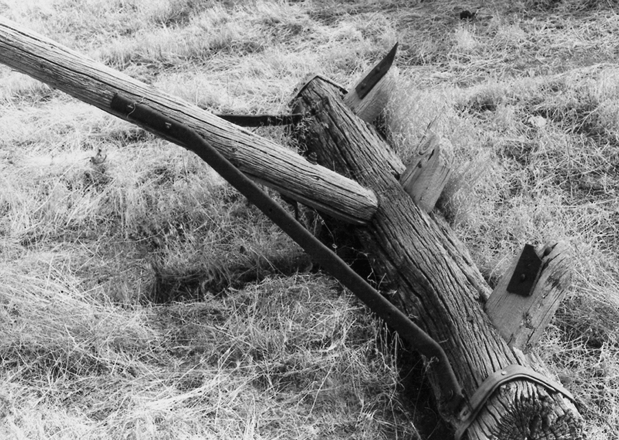
With only 57 plows in the company, preparing the soil was largely cooperative. Since the ground had never been worked, the plows constantly jumped furrows, rebounding from hidden roots and rocks. Well-established sage and rabbit brush had to be grubbed out. The pioneers harrowed with homemade tree-trunk drags (logs studded with pegs in the bottom) to ready the soil for planting (see illus. 4-2). After harrowing, the pioneers would furrow the plots and then broadcast seed grain from bags slung over their shoulders. At the same time, they dug ditches to channel Center Creek’s water through the fields, carefully routing a fair share to each farmer.
Illus. 4-2. Pioneer tree-trunk harrow with wooden pegs for teeth. Photograph by Morris A. Shirts.
The weather remained chilly all spring. Lunt and Smith’s journals are not detailed enough to let us reconstruct a planting log, but many acres had been sown by 25 March. Smith’s letter of this date to Brigham Young illustrates how farming was proceeding in the settlement, despite ever changeable weather. It also reflects the spirit of compromise which John D. Lee had urged upon the pioneers when they first debated the relative merits of upland and wire grass.
We are progressing rapidly in our farming operations, having already sown four hundred acres of wheat, and they will probably amount to one thousand. The soil is considered of the first quality, both upland and wire grass, by our best farmers—no division of opinion regarding soil. There have been about sixteen hundred acres surveyed, and the probability is that it will nearly all be cultivated this season.20
The settlers had found a way past their differences without risk to individuals or the community at large. Now they had to solve the next problem: how to plant, manage and harvest crops in a region where unpredictable weather seemed to be the norm. On 26 March, for instance, Smith himself planted those of his potatoes that had not frozen en route, even though it snowed the night before. Settlers were plagued with wind and snow all spring; nevertheless, they planted wheat, corn, oats and barley as well as garden crops such as peas. Some crops failed when unseasonably warm weather turned chill again, requiring a second planting,21 but the men continued plowing and planting, trying to learn the nature of the land quickly enough to make it produce the crops they needed to survive.
The School and the Bowery
Crowded into the events of this busy spring were a few weeks of school. In late February, Smith had put together a “Wickyup” or Native American shelter. He was proud of its practicality, writing that it was
a very important establishment composed of Brush, a few slabs and 3 waggons, a fire in the Center, and a lot of milking stools benches & logs placed around, two of which are cushioned with Buffalo Robes, in answer for various purposes, Kitchen, School House, dineing room, Meeting House, Council House, Sitting Room, Reading Room, Store Room.22
Smith’s evening grammar school had opened on 21 February, with six scholars who met nightly. He identifies them as Thomas Wheeler, 19; Joseph Millet, 17; Peter A. Smith (Dibble), 15; carpenter Richard Benson, 35; Benjamin Hulse, 36, a ship joiner; and William Mitchell, either the 44-year-old bricklayer or his 16-year-old son.23 George A. describes his school colorfully—scholars huddled around a campfire, the thermometer at seven degrees above zero, “the wind broken off by the brush and the whole canopy of heaven for a covering . . . one side roasting while the other freezing, requiring a continual turning to keep as near as possible an equilibrium of temperature.” Grammar book in hand, George A. “would give out a sentance at a time, and pass it round, notwithstanding these ci[r]cumstances, I never saw a grammar class learn faster for the time.”24
On 23 February, two nights after opening his school, Smith records: “Br. Shirts at my request started a school this Evening in Br Millers House. An Evening Grammar School.”25 Since an analysis of the letters Shirts wrote to Brigham Young (from Brigham’s letter book) suggests that Shirts was hardly qualified to teach English grammar, he may have been teaching other subjects. Neither the names nor the number of students in the class are given. Note that the two men listed as “teacher” on the May 1851 Census, James Lewis and James A. Little, apparently were not involved in these first academic efforts.26
Another makeshift construction that spring was the Bowery. At first, most public meetings were held in the 24-rod square inside the fort. The wind always felt cold no matter which direction it was blowing. On 25 January, president Smith raised a bowery of cedar boughs in front of his wagon for the next day’s Sunday worship. When the Louisa Branch was organized on 9 February, the settlers gathered on the lee—or south—side of the unfinished council house, to escape, in Smith’s words, the “fine wind blowing from the East.”27 On Sunday, 16 February, they held “no meeting to day the weather being to[o] uncomfortable to sit in the open air,”28 by no means the only case of inclement weather. On 19 March, Smith wrote, “The wind blowed very hard from the South, leaving no Tents standing in Camp.” Nine days later came a similar entry: “The wind blew very hard all night and continued so all the day.” The Cartwright wagon caught fire and burned up, a lesson not lost on Smith. “Tremendeous high wind all day,” he commented two days later, on the 30th of March, “dangerous to have fires in waggons.”29
The first Bowery was replaced by a more substantial structure in late February. Luella Adams Dalton provides the following description:
In the spring of 1851, the settlers built the Old Bowery, 54 by 77 feet just west of the Log Council House. The roof was fifteen feet high in the center, sloping down to the sides and covered with scantlings about a foot apart, then covered with boughs from trees. The south and west walls were boarded up with scantling and boards giving some protection from the southwesterly winds. There was a large platform in the south end, which on state occasions was decorated with flowers, boughs, pictures and maps. . . . The Old Bowery was a nice cool shady place for meetings for many years. Many times, President Young’s party were entertained here and the Saints on their way to San Bernardino, California met here. Meetings were still held here as late as 1865, when President Brigham Young’s party came on another visit through the settlements.30
Arrivals and Departures
Other noteworthy events that spring were the arrivals and departures of visitors and colony members. On 17 March, in the absence of an established mail route, Smith appointed “John P. Barnard, Wm. Empy, Capt. A. L. Fullmer, Wm. Bringhurst, Charles Harper & [blank space] Harmison” as a special “express” to carry the mail to Salt Lake City.31 The settlers spent the next few days composing official and personal communications.
Only three days later, an Indian courier identified as “Turnip” arrived from Sanpete Valley with news from Isaac Morley that Amasa Lyman and Charles C. Rich were assembling a company in Utah County, bound for California. Members of the Lyman group were assigned to form a settlement at Cajon Pass near San Bernardino to produce grapes, sugar cane and cotton.32 As noted earlier, a group of missionaries under Parley P. Pratt was also forming. It consisted of Pratt and his wife Phoebe, Francis and Mary Jane Hammond, William and Patsy Perkins, Richard R. Hopkins and wife, John Stillman Woodbury, John Murdock, Rufus Allen, Philo Wood and Morris Miner. They were bound for Hawaii and Sydney, Australia, with Pratt and Phoebe going to Valparaiso, Chile.33
A few days later, on 7 April, a lone rider whom Smith identifies as “Homes” reported that the express had reached the Sevier in four days and that an advance party of the California company (the wagons of the Lyman and Pratt groups, now traveling together) was camped on the Beaver. According to George A. Smith, 10 wagons from this advance party crossed Beaver Ridge on the 8th and were accompanied by an additional “5 for this place.” George A., John Calvin Lazelle Smith and Orson Drake rode out to Red Creek to meet the wagons.34
However, on the very next day, 9 April, Smith records that “our Settlement is increased by the arrival of eight waggons, . . . three women and eight men and a number of children,” none, unfortunately, identified by name. This party brought with them 30 welcome bushels of seed potatoes, which the settlers planted on 25 April. The travelers also brought a letter from Heber C. Kimball, first counselor to Brigham Young, apparently confirming Young’s plans to visit the settlement. There was also a letter from George A. Smith’s wife Lucy Meservy conveying the unhappy news that another wife, Sarah Ann Libby, was very ill with tuberculosis.35
The combined parties of travelers created an influx of 520 people and 157 wagons, temporarily doubling the size of Fort Louisa. Some camped south of the fort, but Smith, Rich and Pratt located a large campsite five miles to the south on Summit Creek. They celebrated “Mormon-style,” with several open-air meetings, usually around campfires. The choir, designated as the Louisa Choir (perhaps indicating that the English and American choirs were singing together), supplied music, and many settlers walked from Fort Louisa to Summit Creek to hear the sermons.
On Sunday, 20 April, while Smith was riding with John D. Lee and their wives in Lee’s carriage, a broken rein spooked the lead team, causing them to swing sharply and overturn the carriage. Smith “curled [him]self up like a sloth and rolled out uninjured,” but Lee and the ladies suffered kicks from the frightened animals and severe bruising from being thrown out of the vehicle. Despite the near disaster, they traveled on to Summit Creek after a replacement wagon was procured and held their Sunday meetings, ending the “cool and pleasant” day listening to hymns performed by the Louisa Choir of singers, “which diffused general joy throughout the meeting.”36
New settlers and families of first settlers continued to trickle in steadily. Samuel Gould, listed in the Deseret News on the original 16 November 1850 “call list” but not on the 11 January 1851 “departure list,” is recorded by Smith as arriving on 8 April with his wife Fanny Gould and his sons (from a previous marriage) John and William.37 On 10 April, Parley P. Pratt, looking around with an admiring eye, praised the success of the colony:
I found the inhabitants all well, and the settlement in a truly flourishing condition. Hundreds of acres of grain had been sown, gardens planted, etc., and the farming land nearly enclosed; together with a most substantial saw mill, and many houses of wood and of sun dried brick, built and in progress. Building materials consisting of timber of the finest quality, viz: pine, fir and cedar, together with good building stone and brick, were scattered in profusion in every direction.
Water ditches were flowing for mills and irrigation purposes in many directions.
Mechanics’ shops were in operation; such as joiners, carpenters, millwrights, coopers, blacksmiths, shoemakers, etc.
All this was the work of two or three months, in winter and early spring; not to mention a large enclosure of pickets in the centre of the fort—a council house of hewn timber, and a bastion of the same material.
The number of men composing the settlement and performing all this work, did not exceed one hundred and twenty all told, including old men, boys and Indian servants.38
The California-bound party left on 26 April, leaving behind them three wagons whose owners were waiting for a Sister Swarthout to have her child. The 22-year-old woman died two days later and became the community’s first Mormon burial, which took place “north east of Louisa in the Cedar grove.”39 With the California party went four of the Iron County pioneers: Philip B. Lewis, called as a missionary with Pratt’s group; and P. George Moore, Chester Towne and Peter Lish, who, according to Smith, joined the California colonizing group after having been in the settlement “all winter.”40 On 28 April, however, there were less welcome departures: “Early this morning Thos. Corbet Denis Wynn Hiram Wolsey and Saml. Bateman left this place for the Gt Salt Lake City. Contrary to my Council.”41
That same day, the company “found some stone coal in the Creek at Cotton Wood [i.e., the future Coal Creek], which had washed down” the streambed. The next day, Smith sent out one party to collect loose iron and another to locate the source of the coal. A day later, the first party returned with “about 150 lbs. of Iron.” Three days later, 3 May, the second party “report[ed] two veins of coal made bare by a land slide 5 miles up Cotton wood Kanyon.” Francis Whitney, a 46-year-old blacksmith from Maine, burned the coal in his forge, making nails and welding pieces of iron together. He pronounced the find “a good quality of Coal.”42
Anson Call returned from Salt Lake City on either 5 or 7 May, leading a company of 16 wagons and reporting that Brigham Young would arrive soon to inspect Fort Louisa.43 Among the new arrivals listed by George A. Smith were Call’s own wife, Mary, and three other sisters joining their husbands: Mary Hofheins, Eunice Holbrook and Jane Hulse. “Miss Hall and two children” are included in Smith’s list. This might refer either to 21-year-old Elizabeth Hall, wife of Charles, or 23-year-old Mary E. Hall, wife of Job P., each listed in the May 1851 Census as having two children. New arrival Juliet Dalton joined her husband, who was Charles W. Dalton, as indicated in the McGregor list (see chapter 2, n. 104).
Of the men listed as members of Anson Call’s company, Chapman Duncan, Peter Fife, Priddy Meeks, James Lemmon, Gilbert Morse, Robert Owens, Harry Dalton and John Dart came with family members whom they had brought down from Salt Lake City to join the settlement. Norman Jarvice, Robert Gallisby, Henry Moggredge, Michael Shaw, George Braffit, Alphonzo Green, L. W. Potter and Ezra Clark (not all of whom were original missionaries) are listed as arriving without any family members.44
Along with the excitement generated by these comings and goings was increased contact with the indigenous population. Late in February 1851, Wakara’s brother Amon arrived at the fort to negotiate an alliance between Wakara’s band and the Fort Louisa settlers. Relations with the Mormons at Manti had soured and Wakara had sent word that he would consider relocating at Fort Louisa to raise corn. On 3 March, Wakara strode into the settlement himself and headed directly for George A. Smith, exchanging a hug for a hearty handshake. They shared a peace pipe and carried on an animated conversation through “signs and guesswork.” Wakara said that he wanted to “build a house and teach his children to work.” Smith concluded, after this discussion, that Wakara was as intelligent as any Indian he had met, “[n]o doubt the master spirit of the Utah Nation.”45
The next day Wakara appeared with Peteetneet, on another diplomatic mission. They made peace overtures on behalf of Chief Taugunt, whose Paiutes had killed Isaac Brown, and reported advising all the surrounding bands not to disturb the Mormons or “even a brute of theirs.” In return, the Utes wanted an opportunity to exchange horses for cattle, to which Smith agreed. The spirit of friendship was tested on 8 March, however, when Jacob Hofheins unintentionally pointed a cannon at the Indian camp. After Thomas Wheeler, the Indian interpreter, explained that the cannon was only part of a training exercise, Wakara suggested his warriors participate. In a show of good will, they donned ceremonial regalia and paraded around the corral on horseback, while Wakara and President Smith reviewed the troops.46
For the next week and a half, Wakara’s band stayed in Fort Louisa to trade. They sold not only horses but also small children to the Mormons who hoped to rescue them from slavery in Mexico and California.47 Finally, on 18 March, Wakara announced that he was going north to fight the Snakes, despite President Smith’s suggestion that he make peace with the Shoshoni tribe. Three days later the Utes departed with much ceremony, Wakara, Peteetneet and a Paiute chief breakfasting with George A. Smith before riding out. John P. Barnard gave Smith a Paiute girl about 4 years old, exchanged for an ox. Before leaving, Wakara delivered what George A. characterized as a “Mormon sermon” to the Paiute chief, encouraging him to engage in honest trading rather than stealing.48
Searching for Coal
With Brigham Young expected in May, the time was right to discover an abundant fuel source of the best kind for making iron. The settlers had previously decided to build the foundry at Iron Springs and use cedar wood for fuel. By 11 March 1851, they had found a one-inch vein of “Pennal” coal near Fort Louisa and by 19 March had exposed it to its full width of six inches. They had not, apparently, considered coking it to fuel a blast furnace, but this would not be surprising if the vein turned out to be of low quality or insufficient quantity for their needs.49
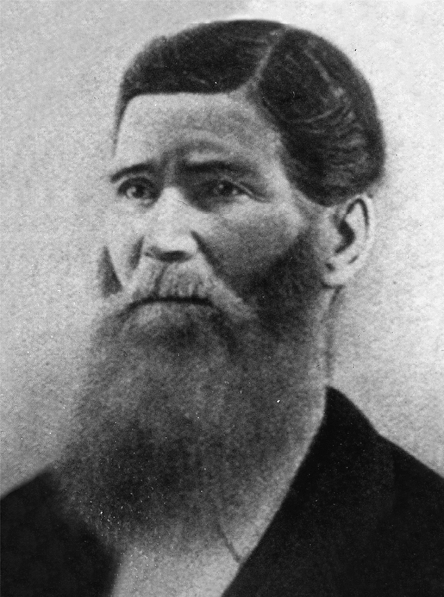
On 5 May, Smith, Aaron Farr, Samuel Bringhurst, Burr Frost, Elijah Newman, Elisha Groves, Robert Green and Peter Shirts (see illus. 4-3) headed out with “Two waggons six horses, blankets and provisions for three days” on an exploring expedition to look for coal. Even after the long day’s ride, George A. Smith’s sense of humor prevailed: “after eating supper, we went to bed. br Farr and myself occupied one waggon, there were Two sides to our waggon, the in side and the out side, br. Farr and myself occupied the former and br Shirts[,] Newman & Groves the latter.” The next morning, despite talking through most of the night with Smith, Aaron Farr cooked breakfast for the camp and then left with Robert Green to bring back several horses that had strayed. The rest of the party headed up the canyon, except for Smith, who remained behind. While he kept camp and read old newspapers, the other five brought back two bushels of coal samples from several veins they had found about a mile up the creek.50 While continuing their explorations the next day, 7 May, Smith found “a splendid sight [sic]” for a city on the banks of the newly renamed Coal Creek. The creek was
a rod whide 15 inches deep very rapid stream, Rocky bed, Soft water milk and water Colour, banks studed with scrub Cedars a few Service bushs and some Spanish Soap root, abundant grass, 5 miles from Coal mines and 10 miles from Iron Mountain; and large tracks of farming land. this point must become a fine flourishing manufacturing Town. About Ten oclock we harnessed our horses, and explored a new road home we guess it at 15 miles.51
This “splendid sight” was the future home of Cedar City.
Illus. 4-3. Peter Shirts (1808–82), prospector and adventurer, was always among the first sent on exploring expeditions. Frank E. Esshom, Pioneers and Prominent Men of Utah (Salt Lake City: Utah Pioneers Book Publishing, 1913), 260.
Sidebar 4-1: Planning a City of Zion
The fundamental concept of the City of Zion, developed in 1838 by Joseph Smith for Far West, Missouri, provided a pattern of village residences on generous-sized lots with farms ringing the city. Isolated homesteads gave way to solid and unified communities. Streets were to be four-square, aligned with the cardinal directions, running east-west and north-south. Brigham Young had deliberately chosen a site for Salt Lake City that allowed precise orientation to the cardinal directions, with farming land close to the city in five-acre parcels, a second ring of farms in ten-acre plots and a third ring in 20-acre plots (generally speaking). This arrangement, by assuring that no single individual would own a large amount of land near the city center, effectively discouraged land speculation.
The same principles seem to have governed Dame’s January–February 1851 survey. He worked within a grid system of blocks and ranges, the standard survey system used throughout the region. Blocks were laid out from a base line running east and west with ranges laid out from a common meridian running north and south. He tried to plot his base lines and meridians from the Great Salt Lake Base Line and Meridian (see chapter 2, n. 32). When plotted on current maps, Dame’s grid system is fairly close to this township-and-range system. His zero point, where prime base line and meridian cross, was toward the northeast corner of Fort Louisa (currently north Main Street, midway along the west side of Block 13 in Parowan—the block abutting the north side of the original fort’s central square). The modern city of Parowan is essentially superimposed upon Fort Louisa and enlarged in relation to it, so its blocks do not line up precisely with Dame’s original survey boundaries, either for the town or its farm lots.
Dame’s eight “outer” blocks were one-half mile wide, running east-west along his base line. His 12 ranges were one-quarter mile wide, laid out on a north-south meridian. Streets measuring either three or four rods (49.5 or 66 feet) ran along the base and meridian lines so that all farms could be easily reached. A set of smaller, “inner” city blocks began at the southeast corner of the townsite, ran north and then south, north, south and north again, and ended with Block 22 in the northwest corner (see chapter 5, illus. 5-1).
Source: For discussion of Joseph Smith’s City of Zion concept, see Leonard J. Arrington, Great Basin Kingdom: Economic History of the Latter-day Saints, 1830–1900 (Lincoln: University of Nebraska Press, 1968), 10.
6. Ibid. The identity of “Bro. Miller” is unclear. Among the settlers were (1) Daniel A. Miller, a 41-year-old farmer from New York, present with his wife Hannah and nine children, ranging in age from 15 to one; (2) Reuben Miller, about whom nothing is known except that his name appears on the list of those called, as printed in the Deseret News of 16 Nov 1850; and (3) Robert Ewing Miller, a 25-year-old ship’s carpenter from Scotland, present with his wife, Eliza, then six months pregnant (see app. 2).
10. Smith, journal, 31 Jan 1851. Lee, ibid., 31 Jan 1851, reports a much smaller group of applicants responding on 31 Jan, the more formal and complete lot drawing, according to Lee, not taking place until late afternoon through early evening of the following Sunday, 2 Feb 1851.
15. Ibid., 12 Apr 1851; Pratt, Autobiography, 375. Although Smith describes Pratt’s property as being 80 acres, the property description identifies it as “One hundred Thirty Acres and Thirty two Rods more or less.” The entry, also dated 12 Apr 1851, is no. 17 on p. 4 of Deed Book A (7 Feb 1851–28 Feb 1855), Iron County Recorder’s Office, Parowan, Utah.
16. On the Philip Lewis deed, the original appears to read “Lot 111,” but as this is impossible, the numeral must be a “10” with upper and lower connecting arcs on the zero faded or worn away. This is proved by the first George A. Smith “Range 7” entry, the ink of which is still dark and readable. The zero of the “10” acre figure there also appears as two slightly curved lines, missing both its upper and lower arc.
17. Smith, journal, 30–31 Jan 1851; Lee, journal, 31 Jan 1851.
18. Smith, ibid., 31 Jan and 3 Mar 1851; Lee, ibid., 3 and 9 Feb 1851. A system of community herding developed in southern Utah as settlements became established. The village bell signaled dairy cow owners in the morning to turn out their animals, which were herded in rotation by boys usually under 12 years of age and thus too young for men’s work. The boys were held strictly responsible for preventing damage to property by the cows, for keeping them from straying or being injured and even for protecting them from Indian raids. Men who had no children of an age to take a turn at herding might be assessed a cent and a half per cow per day.
22. Ibid., 3 Mar 1851. The superscripted phrase in this quotation very clearly reads “& blogs,” but presumably this is no more than a momentary lapse of attention and/or slip of the pen by the writer. The word logs makes perfect sense in the context of the entire passage.
31. Smith, journal, 17 Mar 1851. “A.L.” is Almon L., “Wm.” stands for William in both cases, and Harmison’s first name is James.
32. In Sep 1851, they purchased a 100,000-acre farm at San Bernardino for $77,500 (Dalton, Iron County Mission, 39). See also Edward Leo Lyman, San Bernardino: The Rise and Fall of a California Community (Salt Lake City: Signature Books, 1996), ch. 2, esp. 35–36, 58.
33. Pratt, Autobiography, 371; R. Lanier Britsch, Unto the Islands of the Sea: A History of the Latter-day Saints in the Pacific (Salt Lake City: Deseret Book, 1986), 105.
35. Ibid., 9–10 Apr 1851. She died the following 25 Jun in Salt Lake City. Smith himself seems to have had this potentially fatal disease. On 23 Apr 1851 he records that he “bled a little at the lungs.” Other sources report severe coughing, lung pain and spitting blood. See Jarvis, Ancestry, 261–62.
42. Ibid., 28–30 Apr and 3 May 1851. Peter Shirts, Simeon Howd and George Leavitt appear to have been “the company” or at least some of them who found the stone coal on 28 Apr 1851. A typescript of excerpts taken from George Leavitt’s journal reports that he received a call while at Parowan to help Shirts, Howd “and two others” in further explorations and that, while doing so, the group found considerable iron ore and “at Cedar City, coal,” which they found while eating their dinner by the creek. See George Leavitt, typescript history, SUU Archives.
43. Smith, ibid., 7–8 May and 31 May 1851; Lunt, diary, 7 May 1851. Call’s arrival date remains slightly ambiguous. Lunt records the arrival of Call’s company of 16 wagons on 7 May and Smith writes on 8 May that the party arrived “the day before.” However, on 31 May, where Smith lists the members of this party, he begins by writing “Bro. Anson Call came in with a company and reported to me an account of the company which arrived here on the 5th day of May.”