Eager to inspect the progress of the Iron Mission personally, Brigham Young made the first of many annual visits south in spring 1851. His visit was to have a lasting impact on the community. Not only did President Young establish a new city government, he also called additional ecclesiastical leaders to assist George A. Smith. These new officials would help the fledgling settlement manage tasks associated with growth on the frontier, such as taking the first census and creating an irrigation system.
President Young arrived with a large party at Red Creek, the future site of Paragonah, on Friday, 9 May, just two days after George A. Smith’s party completed a fairly extensive exploration of Coal Creek. Late that evening, Smith rode out to Red Creek to meet the more than 50 travelers and bring them back to Fort Louisa.1 Sidebar 5-1 provides a complete roster of this group.2
Although neither George A. Smith nor Brigham Young’s clerk Thomas Bullock mentions that new recruits or family members of original iron missionaries accompanied Brigham Young, it would have been logical for wives and families to attach themselves to an organized group, as they did to Anson Call’s, which had reached Fort Louisa, bringing mail from Salt Lake City, only a few days before the president’s party arrived. Call’s fellow travelers account for the tremendous increase in the settlement’s population by mid-1851.
Brigham Young brought the colony “a host of letters” from friends, colleagues and family members, plus national and territorial news.3 He was greeted by six inches of snow on the ground, a three-volley salute from the cannon, the singing of school children and the posting of colors. Young’s close inspection and commendation of their efforts buoyed the spirits of these tough pioneers, who were certainly on hardship assignment. A public meeting in the Bowery on 10 or 11 May appears to have been cut short by the weather, but other get-togethers followed in the council house over the next few days.4 President Young spent a good deal of time in private meetings, acquainting himself with the progress and problems of the settlement. He counseled those who were homesick and eager to return to Salt Lake City. He personally inspected the newly built sawmill and newly ploughed farms. On Sunday, 11 May, in the midst of “very hard” wind and rain, he met with “the brethren” and again “made arrangements for to send an exploring company to Coal creek.”5 This or possibly another exploration was made on 15 May.
On 16 May, the president and his contingent took to the road again, joined by a number of men released from their year-long mission in the south. According to George A. Smith, “about 28 of the Iron Co. Mission accompanied [Young] on his return home; part of them to get their families and the residue to attend to their private business.”6
The Iron Mission Record names at least 30 Iron County settlers, two of whom were women, who returned to Salt Lake City at this time: Thomas Bloxom, Francis Boggs, Samuel and William Bringhurst, Ebenezer Brown, Isaac Burnham, Rich Burton [sic], Angus Cannon, Aaron Cherry, Ezra L. Clark, Aaron Farr, Burr Frost, Alphonzo Green, Samuel Gould, Joseph Horne, Joseph Hovey and wife, Simeon Howd, James Lawson, William Leany, George Leavitt, Emily Leavitt, Daniel A. Miller, Joseph Millett, Jonathan Pugmire, Ara W. Sabin, Thomas S. Smith, Charles Y. Webb, Gideon Wood and Samuel Woolley.7
Some of the departures were only temporary. Samuel Gould, often called Father Gould in deference to his age, reappeared on 26 June, bringing his “one milstone” and a report that 17 wagons were on the road behind him. Between the 26th and 27th, George A. Smith reports the return of Isaac Burnham, Washburn Chipman (not listed in the Iron Mission Record), Jonathan Pugmire and Charles Webb, with families. Also arriving were the families of Zechariah Decker, Thomas Cartwright, Elisha Groves, Elijah Elmer and Tarlton Lewis.8
Although there are minor differences among primary sources documenting the iron missionaries and their families, agreement is fairly close. These sources are collated to form appendix 2; differences among them are discussed there. Note that initial records like the “call list” and “departure list” focus on men officially called to form the settlement party. Later records like the May 1851 Census include wives and children, accounting for many more female settlers than the initial sources report.
Taking the Census: May 1851
On the trip down, while his party was camped near Payson, Brigham Young had sent George A. Smith instructions to take a census, and the high priority Smith gave it can be shown by the fact that he began it only two days after Brigham Young arrived.9 This census is extremely valuable. Congress granted Utah territorial status on 9 September 1850, with the news reaching Salt Lake City 27 January 1851.10 A quick and accurate census would be able to chart the growth of new settlements and allow communities to be given fair political representation. This one shows Iron County’s population at 360, a considerable leap from approximately 168 four months before. Certainly, all 360 were not housed in the fort; many were likely camped nearby along Center Creek or on their newly acquired farms.
The May 1851 Census is not trouble-free. For instance, Darius Shirts, 18-year-old son of Peter Shirts, appears on the census records of not only Iron County but Weber and Utah counties as well. Another point of interest concerns John D. Lee, who seems to have listed his family incorrectly, even though he appears to have enumerated the census himself. Juanita Brooks concludes that he gave his plural wife Lovina’s age as 15 rather than 30 in order to disguise her relationship to him by pretending she was a daughter11 (see app. 2 for a correct listing of this family group).
Among other discrepancies are these: Edson Whipple is listed in Andrew Jenson’s “arrival list”12 as having brought two wives, Mary Ann and Harriet, but only Mary Ann appears on the census. “Mrs. Benjamin Watts” is on the “arrival list,” but not on the census (where her husband is listed in the household of James McGuffie). Clarissa Whitney has five (unnamed) children in the “arrival list” but only one child in the census (“New Samuel”), suggesting a possible confusion between herself and Clarissa Hancock, who has six children in the census. John P. Barnard appears on all the sources except the census. He was one of the seven members of the express party carrying mail to Salt Lake City on 24 March. Barnard, Empey and Harmison did not make it back in time for the census, although the others in their group did.
Of those listed in the Iron Mission Record as returning north with Brigham Young’s party on 16 May, Thomas Bloxom, Francis Boggs, “R. T.” Burton, Angus Cannon, Ezra T. Clark, Alphonzo Green, Samuel Gould and George and Emily Leavitt are not on the census, some for obvious reasons. Alphonzo Green and Ezra Clark, for instance, tagged by the Iron Mission Record as returnees, had only been in Fort Louisa some 10 days since coming south with Anson Call’s company, which had rolled into the settlement on the 5th or 7th of May. George A. Smith’s journal entry for the 31st lists the two as coming with Call, immediately thereafter noting that “Alphonzo Green and Ezra Clark returned with Prest. Young.” Ezra’s name appears on the “call list” of November 1850 but he seems not to have traveled south until joining Anson Call’s wagon train. Why both men would come so far in order to stay so short a time is not yet clear.13
The census names all but one of a party of iron missionaries that returned to Salt Lake City on 4 June 1851. This is the first group of pioneers to travel north from the settlement after Brigham Young’s expanded party left on 16 May. Smith organized the 13 men into a traveling company on 25 May: “E. F. Sheets Captain of Company; Chandler Holbrook Seargeant. John D. Lee Clerk & Recorder Anson Call. David Brinton. C. A. Harper John Dolton. James Parks Daniel Hendrix, Leamon Brunson Jefferson Wright, Sixtus Johnson, & Thos. Wheeler.”14 Sixtus Johnson is the only one on the list whose name does not appear on the May 1851 Census. After traveling north with this group, John D. Lee returned to Fort Louisa in November 1851 (by then six months into its new name, Parowan), bringing his family with him.15
One name of interest on the May 1851 Census is that of “John Burton,” a 53-year-old, Virginia-born African-American living with the Joseph Lee Robinson family. He had originally “belonged” to John Newton Burton, a wealthy plantation owner in Virginia, whose widow, Susan McCord Burton, became a Latter-day Saint and married Robinson as his plural wife in Nauvoo on 31 January 1846. When they decided to go West, Susan freed her slaves. John elected to stay with her, using the name John Burton (sometimes spelled “Barton” in pioneer records). He accompanied Brigham Young’s advance party in the spring of 1847 and, on settling in Salt Lake Valley, prepared a farm for the Robinsons. When they arrived in October 1848, he had already grown a crop of corn.16
After coming with the Robinsons to Fort Louisa in 1851, John reportedly helped erect the Old Rock Church. James Martineau’s minutes of a Thursday evening fast meeting on 5 January 1860 briefly mention John, suggesting—beyond his known attributes of loyalty and industriousness —that he was a spiritual man as well: “Br. J. P. Hall spoke in tongues, and John Barton (a slave) interpreted. The burden of Br. Hall’s word was to the effect that great and important events were now being consummated in the world which we would soon hear of, and of the importance of living our religion.”17 When Susan Robinson died, John intended to return to Missouri, hoping to locate his wife. He became ill, however, after reaching Salt Lake City on the first leg of his homeward journey. He died there and is buried in City Cemetery.18
The May 1851 Census confirms the multi-regional, even multi-national makeup of the Iron Mission. Approximately 30 percent of those over 17 years of age came from New York, Pennsylvania, Delaware and New Jersey; about 20 percent came from New England; another 20 percent came directly from England, Scotland, Ireland or Wales. Almost 15 percent came from the Midwest and a slightly lower percentage than that from the South. Thirteen individuals came from Canada and four from Germany.19
From Traveling Company to City Government
Brigham Young’s trip to Fort Louisa was obviously not just a pleasure jaunt. In the seven days of his stay, he set a remarkable number of activities in motion, of which the census was the first. The second was (we can infer) approving a location for the intended new settlement 20 miles to the south, near Coal Creek. Smith records that on Thursday, 15 May, Young visited the mill and farms, then rode up to Summit Creek where he and his party viewed “Coal Creek or Iron valley all of whom were delighted with the prospect.”20 Although this journal entry does not name a specific site chosen by the president or record any orders from him authorizing its colonization, Smith’s words clearly imply that Brigham gave his blessing to the Coal Creek venture. Settlement there could proceed as soon as the harvest at Fort Louisa was safely gathered.
A third event, held 16 May while Brigham Young was still present, was the nomination of John Bernhisel as congressional delegate, a position he was already occupying. Also nominated were George A. Smith as “Council for the Teritory of Utah” (he later calls himself a member of the “Territorial Council”) and Elisha H. Groves as candidate for legislative representative from Iron County. Formal elections were held 4 August 1851, at which all three were elected, presumably without opposition.21
The fourth accomplishment was organizing a formal city government to replace the ecclesiastical fiat by which George A. Smith was authorized to act as chief judge of the county and president of the mission. Ecclesiastical government first took the form of a traveling system—two companies of 50 with captains of 10 within each. It had worked well on the road. As early as 19 January 1851, John D. Lee records George A. Smith discussing whether to build the council house, survey the fort and make the canyon road, all under the administrative structure of the traveling system. While some felt that “more labour could be done under direction of Bishops than of capt[ain]s,” the consensus was that the men would prefer to continue working under the system with which they were familiar.22
By 9 February, however (see chapter 3, n. 76), the new settlement was organized into four wards. Smith observed that the “company organization was disolved & that our future opperations would be carried on under the direction of the Bishops . . . & that it would be pleasing to him to have the Bishops all manage the affairs of their respective wards expecially the public work under same form.”23 The four bishops were Anson Call, First Ward; Tarlton Lewis, Second Ward; Daniel Miller, Third Ward; and Joseph L. Robinson, Fourth Ward. All male settlers, irrespective of their actual priesthood offices, were organized into an “Elders Quorum,” including, by his own request, George A. Smith, who was a high priest.24 Thus, the bishops were responsible to supervise not only the spiritual but also the public affairs of the community with the elders quorum acting as legislative body. This system, while suitable for the young Fort Louisa, would burden bishops unnecessarily as the town grew and cease to work once non-Mormons moved in.
While in Iron County, Brigham Young “gave some excellent instructions on government.” On 16 May, under his direction, the residents organized a municipal government, which Smith listed in his journal as William H. Dame, mayor; Richard Harrison, Tarlton Lewis, John D. Lee and Matthew Carruthers, aldermen; and Andrew A. Love, Joel H. Johnson, William A. Moss, William Leany, Dr. Priddy Meeks, Elijah Newman, Robert Wiley, John Wolf and John Dolton, city council members.25
The territorial legislature created a county government less than two weeks before the iron missionaries left for southern Utah, but no city government was created at the same time. However, by 6 February 1851, soon after the travelers “arrived,” the legislative assembly approved a charter for a city to be called “Parowan,” the same day granting charters to Ogden, Manti and Provo. Salt Lake City had been granted a charter a month earlier on 9 January. That document was patterned closely after Nauvoo’s, granted by the Illinois State Legislature, and the others were virtually carbon copies of Salt Lake City’s. The entire Parowan charter consists of 47 sections; Sections 3 through 45 are common to all five charters.26
It is interesting to note that the incorporation ordinance identifies the city as “Parowan” even though no such city yet existed. Sec. 1 gave its boundaries as
beginning at the dam, above the sawmill, in the mouth of the kanyon, on Centre creek, and running from thence north-east along the base of the mountain two miles; thence north three miles; thence west six miles; thence south to the base of the mountain; thence along the base of the mountain in a north-easterly direction, to the place of beginning.
The settlers were given a two-year exemption on road taxes beyond the city limits.27 The dam was not even built, although construction began 6 February, the day the charter passed. Certainly the legislators did not know the dimensions of the city. Perhaps they had passed the description provisionally, pending exact information from the field. It is also possible the boundaries were written in after the fact.
What is most curious is that the first reference to Parowan in Smith’s journal is not made until 9 March when he points out the Little Salt Lake on his copy of John C. Frémont’s map to Chief Wakara, who tells him the correct name is Parowan Lake.28 In fact, three days after the legislative assembly designated the city as Parowan, it was formally named Fort Louisa on a motion by John D. Lee. On 16 May, however, when the company finally organized the city they had been granted in the charter, they chose to name it Parowan.29
One result of organizing a municipal government is that George A. Smith, whose powers had been virtually unlimited, now petitioned the city council for authorization to operate his mill and the county for permission to use the canyon’s timber, grass and creek water. On 12 June, he refers for the first time to employing men to work on his mill, suggesting that they had earlier donated their time as though to a public project.30
The fifth project which received Brigham Young’s scrutiny was finding an alternate route to Beaver Ridge, an extremely rough and steep section of the road where wagons routinely had to be double-teamed. On 17 May, Smith and a small party accompanied the president’s group back over this ridge (“a weary ride over the mountain”) as far as Beaver River, which would have been a jarring reminder of the difficulties of freighting over that section.31
Evidently Brigham Young assigned Smith to find a better route; on 30 June, Smith sent Peter Shirts and Samuel Gould “to explore a rout for a State road to the Beever.” They returned a day later to report “an excellant rout to the Beever, without a mountain but would cost some labour to make the road.”32 The route ran east of Beaver Ridge, entered Parowan Valley at the northeast end, turned a little left and ran over a small ridge down into Nevershine Canyon. George A. Smith was one of the first to use it when he left the Iron Mission in November 1851 for his new duties in Utah County:
At the Elk Horn Springs, 14 units from Parowan, we took a new road, recently broke by John D. Lee & co., through a pass, which avoids the rough and steep crossing of the Beaver mountains. This road had been broken out through heavy sage, by the passing of 20 wagons of bro. Lee’s company, being piloted thro’ by Mr. Samuel Gould of Parowan. It is a grand improvement in the road.33
The Water Crisis
The months following Brigham Young’s May 1851 visit to Parowan were hectic ones of reappraisal and readjustment for Smith. Every day seemed to produce a management crisis of some kind. His personal affairs needed attention and his civic, church and administrative functions demanded equal amounts of his time. He was busy overseeing completion of the mill, including the repair of the millrace and waterwheel. He was building a permanent adobe home on the south side of the public square. The fence around the Big Field, which was under his supervision, needed almost constant repair. Strong winds roared out of the canyon and a late frost nipped the gardens. Roads had to be surveyed and built, not only into the canyons but also to Coal Creek, Cedar City’s future site, and through the mountains to the Beaver River. The continuing Indian presence called for regular sentry duty and militia drills. New colonists needed constant help to locate and settle in. More personally, his wife Sarah Ann Libby had died in Salt Lake City of consumption and he himself was shaken with recurring bouts of what was almost certainly the same disease.
In the midst of all the other activities, an unexpected crisis occurred. That spring, Center Creek’s abundant waters suddenly and alarmingly dropped off. On Sunday, 15 June, George A. Smith “spent the evening in counciling about herding the Cattle, fencing, divideing of the water. The water was considered deficient for watering our crops. A committee was appointed to see if Red Creek or Summit Creek could be brought onto the rabbit brush or wire grass land.”34
On 17 June, this committee (Joel H. Johnson, Tarlton Lewis and William H. Dame) reported that diversion was not possible. On the same day, Smith observed that the volumes of Coal Creek and Red Creek were also falling.35 While the settlers had prepared for much they might find on arriving in a new country, they had no inkling that seasonal water fluctuations were tied to local weather patterns and the geology of this unfamiliar terrain. Thus, from the very beginning, the colonists were scrambling to learn the lessons of the land on which their survival would depend.
Newton Goodale, a 36-year-old farmer from New York, not satisfied with the committee’s report, took his own level on Red Creek and told Smith that it would be possible to divert its waters to the Big Field “as far up as the Rabbit brush dam.” Smith promptly appointed him chief engineer of the Parowan Canal Company, organized the same day, and assigned Chapman Duncan as clerk.36 All the men in the community worked on the project, which was completed 2 July, but the ground was so dry it was difficult to get the water through it. In a report to Brigham Young published in the Deseret News, 26 July 1851, Smith wrote:
To increase the water we have made a canal about seven miles in length, to bring in Red Creek, to water the lower surveys in our field. This has been quite a job, and had not the colony been weakened by the return of a part, this would have been completed one month earlier, thereby saving thousands of bushels of grain. It seems almost incredible the amount of labor that has been done, and yet much is before us, and every man is straining every nerve to accomplish the task before him. The Wire Grass Survey which was thought by the WISEST farmers to need but little water, upon trial requires double the amount of the upland.37
It must have been with some relief that George A. Smith took time off on the 4th of July, although the pioneers, with their complement of Englishmen, had given scant notice to the national birthday. Smith’s journal entry notes merely that he “spent the day in fus[s]ing round the mill, and reading a discription of California. All was silent, not a gun fired, nor a drunken man seen in the Streets.”38
The 24th, however, was livelier. This day celebrated the arrival of the Mormon pioneers in Salt Lake Valley in 1847. The Parowan pioneers began the anniversary with a 7:30 a.m. flag-raising. The cannon was fired and an infantry battalion formed up, marching in drill and discharging their weapons “in plattons” while the citizens formed their own procession at 9:30 and marched to the Bowery for an oration interspersed with hymns and sentimental songs. George A. Smith reviewed pioneer explorations into the mountains, after which the settlers returned to Parowan house to a postlude of cannon fire. Smith then notes taking dinner with Orson Adams and 30 others, “an excellent feast in which the fruits of our valley formed quite a variety.” By four o’clock, dancing commenced under the watchful eyes of Bishop Groves and George A. Smith and continued “until a late hour.”39
George and Zilpha Smith were finally able to move into their partially completed house on 26 July, as he recorded with obvious satisfaction: “Worked on the house, finished the roof, and the floor, moved into it. br Webb moved into the house, I moved out of. And for the first time since I left Gt Salt Lake City slept on a bedstead.” Any sense of ease that the Smiths might have felt, however, was to be short-lived, as George A. was soon to be on the road again, to attend general conference and visit his other families in Salt Lake City. But before he began the preparations for the trip, he took time, on 28 July, to perform the first marriage in the colony, uniting Robert Gallisby and Phoebe Dart, noting that the bride “married contrary to her fathers wish.”40
George A. Smith’s Return to Salt Lake City
Events were progressing well enough in the settlement to make Smith confident about leaving for general conference, scheduled to begin on 7 September 1851. On 31 July, he recorded, “I took my waggon to Pugmires [blacksmith Jonathan Pugmire] to be repaired ready for the trip back to the Gt. Salt Lake.”41 Between then and his departure on 21 August, he was busy administering colony affairs and making final preparations for the trip.
On 4 August, after the settlers elected George A. Smith to the territorial council, the 14 who were traveling to Salt Lake Valley with him met and organized themselves into a traveling company, Peter Shirts serving as captain and J. C. L. Smith as clerk. That evening the colony celebrated with another dance in Peter’s Parowan house. Three days later, on 7 August, one of the greatest rainstorms of the season struck, raising Center Creek by a foot and flooding the city with water “as red as blood.”42
Because George A. Smith’s wife Zilpha was ill, many of the colony’s women stepped in to help sew and bake for his trip, outfitting him along with their own husbands. Individual settlers contributed hay for the horses, 15 pounds of beef and a sage hen. Smith built a chicken coop as well as a privy, with an ash bin to control the flies and odor. He tended to a seemingly endless array of little difficulties. When the quorum passed a resolution on 10 August forbidding their Indian neighbors to glean or work in the community’s Big Field, Smith revoked it, claiming that the quorum had interfered with his prerogatives as president and that the Indians were to be permitted in the fields as long as they worked.43
On Sunday, 17 August, as his last official act before his conference trip, Smith appointed Elisha H. Groves (elders quorum president) to act as Iron Mission president while he was gone. The people voted unanimously to write Smith a letter of recommendation for the work he had done, signed by Groves and the clerk. Smith settled his accounts, rented his mill to Richard Benson and, on 21 August, left Parowan at 9 a.m.44
Remnants of Pioneer Parowan in the Modern City
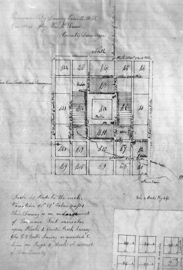
The original survey of Fort Louisa in February 1851 had called for lots two rods by four rods or 33 by 66 feet. By November 1852, Dame had surveyed the settlement, now Parowan, a second time and started assigning the new lots (see illus. 5-1). Zadok K. Judd received the first, dated 2 December 1852 (see app. 3). This new survey plat preserved the basic design of Fort Louisa but provided for Parowan’s future growth. Dame enlarged the lots by adding 20 rods to each, making them two rods by 24 rods long, or 33 by 396 feet, creating a total of 18 new blocks. The new lots were, as one old-time resident put it, “damned long corn rows to weed” and were inconveniently narrow. By about 1854, two years later, the Parowan settlers had begun dividing these lots in half and building homes on opposite ends of them, facing new streets.
Illus. 5-1. William H. Dame’s second survey of Fort Louisa, now renamed “Parowan City,” dated January 1853. See app. 3 for lot owner assignments in Parowan City. This plat is furnished for information only. No liability is assumed by Assessor’s or Recorder’s Office as to correctness of such data. Iron County Recorder.
Fort Louisa’s basic plan had, from the beginning, lent itself to division into blocks. In the new survey, the east side of the public square (the Fourth Ward) was designated as Block 6, the south side (First Ward) as Block 11, the west side (Second Ward) as Block 16 and the north side (Third Ward) as Block 13. The square itself was designated as Block 12. Dame also eliminated the council house square in the southeast corner, enlarging the bastion square in the northwest corner of the fort plat into a “bishops’ square” that housed a church, a barn and a storehouse to accommodate contributions in kind.
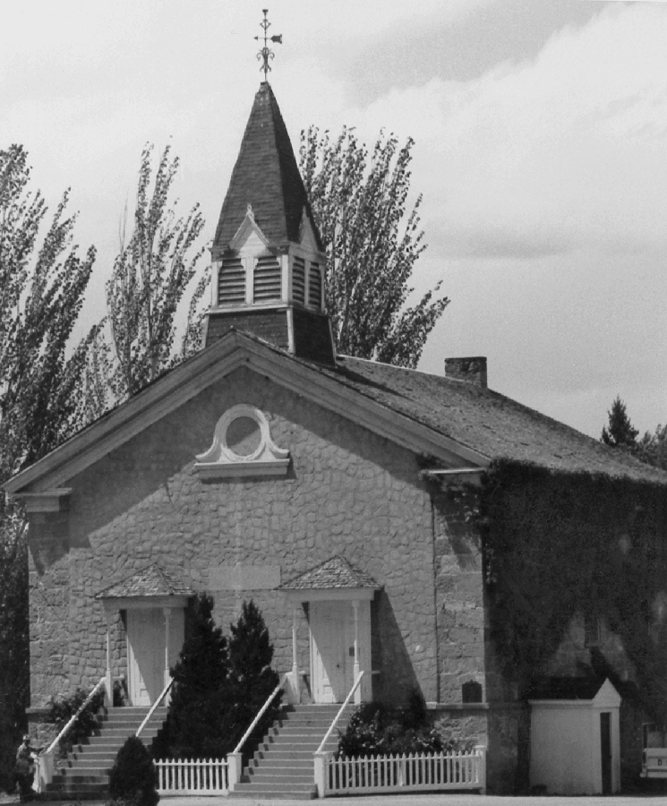
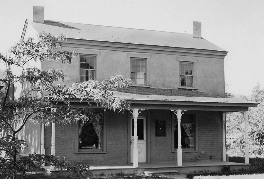
The Old Rock Church, Parowan’s most familiar LDS building, sits in the middle of the pioneer fort’s public square (see illus. 5-2). All houses currently standing on blocks around the church face the square; many lots are still either 33 feet wide or just double that size. Over the years, lots facing the square have been combined through selling and trading, but many retain their original widths or multiples of 33 feet. Modern Parowan’s city offices, on the southeast corner of Main and First North, are housed in the former Bank of Iron County, constructed about 1920. This building is approximately 33 by 66 feet. The building located at 13 South Main, on the east side of the square, is 66 feet wide. On the south side of the square, Block 11, the Jesse N. Smith home, which is on the state historical register, is on a lot 99 feet wide (see illus. 5-3).
Illus. 5-2. Parowan’s Old Rock Church, located in the center of the public square, facing south. Photograph by Morris A. Shirts.
Illus. 5-3. Jesse N. Smith home, located on the south side of the public square (Block 11), facing north. It was constructed of adobe brick in 1856–1857. It has since been restored and is listed on the State Register of Historical Sites. Photograph by Morris A. Shirts.
George A. Smith’s first lot was located on the south line of the fort, just west of the council house (First Ward, Block 11, Lot No. 1). On 30 May 1851, Smith apparently purchased a new lot, engaging with “Br. James Lewis for 10,000 dobies and his foundation on south street.” The purchase took place after Smith sold his log house and one of his lots on the east line to Elijah Elmer in exchange for $200 work on the sawmill.45 Mary Amelia Smith, the daughter of George A. and Zilpha Smith, married Peter Wimmer and the couple may have lived in the home on the Lewis lot. The Smith-Wimmer house, known locally as the old Wimmer house, stood on or adjacent to Lot 5 of the early survey. One wall of the Mortensen barbershop (still standing at 15 West 100 South, but no longer operating) was reportedly part of the Smith-Wimmer home.
A man named Morgan Richards, on a date not recorded, reportedly purchased the other Smith lot on the east side of the fort in Fourth Ward.46 Tradition identifies this lot with Lot 9, east of the fort (Block 6), where Zadok K. Judd built a home at 25 South Main Street. The lot was recorded to Judd on 2 December 1852.47
Lots on the north side (Block 13) have been subdivided into more diverse measurements—some about 58 feet, others about 73 feet. We can also see these changes at work in some of the property transactions occurring on the west side. An analysis of Deed Book A reveals that Andrew Baston, for example, early in 1852, owned Lot 23 and part or all of the north half of Lot 22. By deed of 21 January 1852, Jacob Hofheins became “entitled” to Lot 21 and the south half of Lot 22. On 27 November 1852, Daniel Page purchased Baston’s property (the word “estate” is penciled in, suggesting Baston had died by this date). Page then sold this property to Hofheins.48 Subsequently, Robert E. Miller bought at least a portion of the Hofheins property, which he sold to William Wilcox on 27 June 1863. The pertinent deed describes the property as “the east part of lots 21 & 22 and 7½ feet on the south side of east part of lot 23 being 7½ feet front by 14 rods Parowan City Survey Block 16 Plat A.”49 Evidently, the 10 rods on the west had been sold to someone else and the combined width of Lots 21, 22 and 23 became 73½ eet.
Some lots were deeded back to the city for municipal purposes. After an adobe wall was built around the city’s perimeter in 1855, it became necessary to provide streets through the center of each block surrounding the public square. Seth Rogers ceded Lot 14, Block 6 (east side), Edward Thompson ceded Lot 11, Block 11 (south), and Ross Roberts ceded Lot 10, Block 13 (north). Lot 15, providing street access on Block 16 (west side), lists no grantor.50
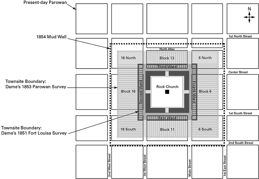
The streets on the east and north eventually reverted to private hands. The western street is still faintly visible on the property formerly owned by Wilford Durham; the south street is the only one still a public thoroughfare. By collating William Dame’s first and second surveys (1851 and 1853) with the 1921 map of Parowan made by Joseph Richards, we notice that some streets were widened by condemning other lots, still identified by Dame’s 1853 numbers. Center Street took Lots 3, 4 and 5 from Block 6 and Lots 24, 25 and 26 from Block 16. First South took Lots 24, 25 and 26 from Block 6 and Lots 3, 4 and 5 from Block 16. Main Street took Lot 1 from Block 11 and Lot 20 from Block 13. First West took Lot 20 from Block 11 and Lot 1 from Block 13 (see illus. 5-4).
Illus. 5-4. William H. Dame’s 1851 and 1853 surveys superimposed over corresponding sites in modern Parowan using the 1921 map of Joseph Richards as a base.
Federal legislation, enacted by the Homestead Act of 1862 and extended to Utah in 1867, permitted the settlers of Iron County to claim, for a nominal charge, the federal lands they had occupied and improved. Probate courts, established in Iron County in 1872, processed these claims; title abstracts in the county usually begin from that year. Municipal entitlements also increased as population growth stimulated a more sophisticated response to community planning. In April 1872, for instance, Parowan City formally claimed the lots in the public square, creating a city center around which new business and professional enterprises could develop.51 Returning the public square to community ownership for the benefit of all citizens was an action entirely in keeping with the spirit of those who founded Fort Louisa in 1851 and underscored the enduring vision connecting the modern city to its pioneer prototype.
Sidebar 5-1: Brigham Young’s 1851 Traveling Company
Brigham Young and (unnamed) wife
George Bean
E. T. Benson and wife
William Bringhurst
Thomas Bullock
Robert J. Burton
Cyrus Canfield
Daniel Carn
Miron Crandell
John S. Dunton
Horace Eldridge and wife
Ira Eldridge, wife and child
Stephen H. Goddard
George D. Grant
Jedediah M. Grant and wife
Joseph L. Heywood
Jerrius Hollister
Dimick Huntington
Benjamin F. Johnson
Heber C. Kimball, wife, and Heber T. Kimball
Thomas Rhodes
Abraham O. Smoot
Samuel Sprague
Levi Stewart
Seth Taft
Stephen Taylor
Hansen Walker
Daniel H. Wells
Daniel Wood
Wilford Woodruff
Brigham J. Young, Joseph A. Young and Lorenzo Young “and others.”
Source: Journal History, 2 May 1851.
Sidebar 5-2: Iron Mission Leadership
In Parowan
In Cedar City
April 1850 President, Iron Mission George A. Smith
9 Feb 1851 Bishops of Parowan Wards Anson Call, Tarlton Lewis, Daniel Miller, Joseph L. Robinson
16 May 1851 Mayor of Parowan William H. Dame
17 Aug 1851 Acting President, Iron Mission Elisha H. Groves
28 Oct 1851 President, Iron Mission Elisha H. Groves
1st Counselor John Lyman Smith
2nd Counselor Matthew Carruthers “1st Counselor” “2nd Counselor” John Easton*
12 May 1852 President, “Stake of Zion,” Iron County; General Manager, iron works John Calvin Lazelle Smith
1st Counselor John Steele
2nd Counselor; Supervisor, iron works Henry Lunt
Bishop of Parowan Ward Tarlton Lewis
Bishop of Cedar Ward Philip Klingensmith
18 Jun 1853 Mayor of Parowan John Steele
26–27 Nov 1853 General Manager, Deseret Iron Company Isaac C. Haight
6 Dec 1853 Mayor of Cedar City Isaac C. Haight
20 May 1855 President, Cedar Stake Isaac C. Haight 1st Counselor Jonathan Pugmire 2nd Counselor John M. Higbee
21 May 1855 President, Parowan Stake John Calvin Lazelle Smith 1st Counselor Jesse N. Smith 2nd Counselor James H. Martineau
Spring 1856 President, Parowan Stake William H. Dame 1st Counselor Calvin C. Pendleton 2nd Counselor Jesse N. Smith
31 July 1859 President, Cedar Stake; Bishop, Cedar Ward Henry Lunt 1st Counselor Richard Morris 2nd Counselor Thomas Jones
*Lunt, diary, 2 Feb 1852, records that these two “councillors” were “unanimously Elected” to assist Matthew Carruthers. This unusual step—calling counselors to a counselor—reflects the growth of the new colony in Cedar City.
9. Zabriskie and Robinson, “U.S. Census for Utah, 1851.” At that time, Utah had seven counties: Davis, Iron, Salt Lake, Sanpete, Tooele, Utah and Weber.
10. Whitney, History of Utah, 1:452. As noted in ch. 3 above, Jefferson Hunt revealed his important news to the iron missionaries as early as 14 Jan 1851, meeting them on the trail just as they were arriving at Little Salt Lake Valley and he was returning to Salt Lake City from California.
14. Ibid., 25 May 1851; see Larson’s commentary following entry for 1 Mar 1851 in Lee, journal, 382.
15. Brooks, John Doyle Lee, 169–70; Smith, journal, 25 May 1851.
16. Kate B. Carter, comp., Our Pioneer Heritage, 20 vols. (Salt Lake City: Daughters of Utah Pioneers, 1958–77), 8:509–10 (excerpting Joseph Lee Robinson journal).
17. James H. Martineau, Parowan Stake History, Stake Meeting Minutes, 11 Aug 1859–13 Feb 1860, entry of 5 Jan 1860, 61, film 1,666,076 (as of this writing), Family History Library, Salt Lake City.
23. Ibid., 9 Feb 1851 (as described in the second passage so dated).
24. Ibid. Larson’s commentary, at 376 nn. 33 and 35, is relevant here. See also Lee’s “Elders Quorum” references on 23 Feb 1851 (misdated “Sund. 23rd March”).
25. Smith, journal, 16 May 1851 (Smith’s spelling of surnames retained).
37. George A. Smith, letter to editor, 2 Jul 1851, published in Deseret News, 26 Jul 1851, 301. The phrase “return of a part” refers to those who, for whatever reason, left the Iron Mission to return to Salt Lake City, thereby draining the settlement of critically needed manpower.
45. Ibid., 30 May 1851. Elijah Elmer’s surname is spelled “Elmore” by Smith.
46. The exact identity of Richards is difficult to determine. Candidates include Morgan Richards Sr. (“an artist” in plaster and concrete), Morgan Richards Jr. (clerk, later superintendent, of the co-op), and possibly a cousin, also named Morgan, all from Glamorganshire, Wales. Morgan Jr., born in 1845, later became state auditor (1896–1901); his son, Alma Richards, won the gold medal for a 6½ foot high jump in the 1912 Olympic Games in Stockholm, Sweden. See Dalton, Iron County Mission, 64, 304, 368–70.
51. Lawrence B. Lee, “Homesteading in Zion,” Utah Historical Quarterly 28 (Jan 1960): 29–30; Deed Book D (12 Aug 1863–16 Sep 1874), 253, Iron County Recorder’s Office, Parowan, Utah.