The process of founding a new settlement, as Parowan demonstrated, consumed the settlers’ lives and dictated priorities in the 1850s outside the Salt Lake Valley. Immediate safety, long-term security and future productivity were central to successfully inhabiting the wilderness of southern Utah. None of these concerns was left to chance. Settlers typically picked a site first and then surveyed it. Next, colonists built a corral to keep their livestock from wandering off and erected a fort to protect themselves against intruders. Laying out fields for planting and making provision for irrigation occurred simultaneously or very shortly afterward. Then individual families began building homes and cultivating their garden plots.
The Wagon-Box Camp and the “South Side” Corral
When the settlers first arrived from Parowan, on the afternoon and evening of 11 November 1851, they lifted their wagon boxes off the running gears and used the boxes as temporary shelters. By the time David Bulloch rode into Coal Creek, members of the Parowan advance party had already placed two of their wagon boxes on the ground under some cedar trees. According to Bulloch, the incoming pioneers placed their wagons “in line each one facing south” and created a “Cedar brush Wickiup” in front of each wagon, providing shelter and protecting the individual campfires.1
Tradition locates this camp in the cove on the north side of the 200 ft. high Knoll which lies just north of present-day Cedar City.2 For example, Alva Matheson, recalling his father Alexander’s recollections of early pioneer stories, places the Wagon-Box Camp in the cove on the north of the Knoll as the best site to provide shelter from prevailing southwest winds. Matheson believes the wagon boxes were placed on a north-south line facing east, clearly a different orientation than that remembered by David Bulloch in his “Life Sketch.” Both William Palmer and his sister Kate Palmer Macfarlane interviewed Bulloch just before his death on 18 January 1928 at age 83. Macfarlane agrees with Matheson that the wagons faced east. After his own interview with Bulloch, however, William Palmer drew a sketch of the Wagon-Box Camp (see illus. 7-1) which shows the wagons placed in an east-west line facing south. Since Alexander Matheson and the Macfarlane interview come to one conclusion while Bulloch’s “Life Sketch” and the Palmer interview come to the other, the question of precise orientation remains in doubt.
This is not the only example of debate over primary sources among modern commentators. Sorting through these issues depends upon an understanding of the nature of the sources themselves. The Whittaker journal, kept jointly by James Whittaker Sr. and son James Jr., gives the best information on the early weeks of the Coal Creek settlement. Henry Lunt, usually a steady journal-keeper, wrote little on the colony’s first days. After recording arrivals of the first groups from Parowan on 10 and 12 November 1851, he is uncharacteristically silent. A single entry appears on 2 January 1852, after which nothing is noted until 1 February. He then skips 5–15 February, makes a single entry on the 16th and ceases recording until 26 March, after which daily entries more or less resume. This is even more surprising when we realize he made no entry concerning his own wedding, on 25 March, to James Whittaker’s daughter Ellen, merely noting the next day that “Myself and wife took Breakfast with our Parowan friends.”3
Complementing Whittaker’s and Lunt’s records are David Bulloch’s “Life Sketch” and John Chatterley’s “History of Cedar City.” Each man was an eyewitness of the town’s infancy and growth; each left brief but vivid and informative recollections of those years. This places them near in value to Whittaker and Lunt, but not quite equal, because both memoirs were written many years later, when details may not have been remembered accurately.
A third level of historical documentation stems from accounts like those of William R. Palmer, Katherine (Kate) Palmer Macfarlane, Gladys McConnell, Rhoda Matheson Wood, Belle Armstrong and John Urie. While providing valuable information by way of compiling the written recollections of first settlers or reporting the results of interviews with them, these sources must be handled with care because they sometimes contain undocumented assumptions. Sometimes they also depend too heavily on unconfirmed local tradition and family anecdote.
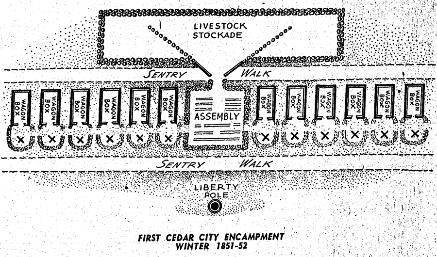
Studying two examples of source misinterpretation gives us a clearer picture of the earliest structures in Cedar City: the “Wagon-Box Camp” and the “Compact Fort.” (We use these descriptive terms to distinguish one site from the other and both from later Cedar City place names.) In the Improvement Era of March 1951, William Palmer published an article entitled “Pioneer Fortifications.” Well organized and detailed, it is based on years of research, including interviews that produced many notes and several drawings. The article contains an illustration of the Wagon-Box Camp (see illus. 7-2). Palmer writes that the wagons were placed “in a long straight line running east and west, and all fronting south,” thus reaffirming the orientation of his informal sketch shown as illustration 7–1.4 A central gathering area, midway down the line of wagon boxes, is visible in both that sketch and the Improvement Era drawing. In the sketch, it is labeled “Brush Meeting h.,” i.e., a brush-enclosed meetinghouse; in the drawing, it is labeled “Assembly.” To the drawing, however, Palmer has added an attached and gated “Livestock Stockade”—smaller, separate and ungated in the sketch—and a “Liberty Pole” on the other side of the assembly area from the stockade (not present in the sketch). Palmer describes this first encampment in the article:
On the north side and just across the sentry walk, a large stockade was built to protect the livestock. It was made by standing drift logs on end side by side in a trench, forming an arrow-tight wall. The gates were so arranged that when pulled open with a rope they bumped against posts in the wall of the meeting court. The settlers could then move from their wagon boxes to the court and on into the picket stockade and be under protection all the way.
Across the sentry walk on the south, a tall, straight liberty pole was raised. It was dedicated with solemn prayer: “To liberty, to justice, and to God.” . . . Officers of the colony met in the brush court to discuss and formulate regulations and laws, but they were not of force until they were proclaimed from the liberty pole.5
Illus. 7-2. The “Wagon-Box Camp.” Illustration from William Palmer, “Pioneer Fortifications” Improvement Era 54 (March 1951), 149.
A close reading of the primary sources reveals inconsistencies with the information published in Palmer’s Improvement Era article. First, Palmer’s description fits the larger, more permanent corral erected at the south end of the Compact Fort site—not the temporary corral that is presumed to have existed near the initial campsite. Second, Palmer adds a central assembly area not present in any of the early sketches. Third, the liberty pole, clearly noted in his text and marked on his drawing as a feature of the Wagon-Box Camp, was never located there; it was erected for the first time in the center of the Compact Fort site, which did become the place of general assembly.
Similar problems arise when using Rhoda Matheson Wood’s article “In the First Fort,” where she states that the wagon boxes were “set in a straight line within the surveyed 300 ft. square” and that “a wall of rock, mud, brush and cottonwood was hurriedly thrown up to provide a corral for the stock and a windbreak for the camp. Thirty-five c[a]mped there the first night.”6 As with the Palmer article, many discrepancies arise. For example, the reference to the survey area size clearly indicates Wood is confusing the initial Wagon-Box Camp with the later Compact Fort site. She gives a survey figure (300 ft. square) as though it were a known fact, when indeed the fort size is not consistent in any of the sources. Moreover, the reference to the wall being hurriedly thrown up is a collation of several journal entries, some that prove to be describing activities around the Wagon-Box Camp and some the construction of the Compact Fort. And saying that exactly 35 persons were present the first night of settlement is questionable, because the primary sources do not identify a precise number of first arrivals. Possibly she took the number 35 from John Chatterley’s reminiscence in which he recorded the names of everyone he could think of who came to Cedar City on 11 November, a list that names “33 of the 35 men” who supposedly arrived that day. Or she might have taken it from the rosters of Company C and F, which total 36 men. Her article lacks preciseness, which materially lessens its value both to the general reader and to the serious researcher on the trail of historical fact.
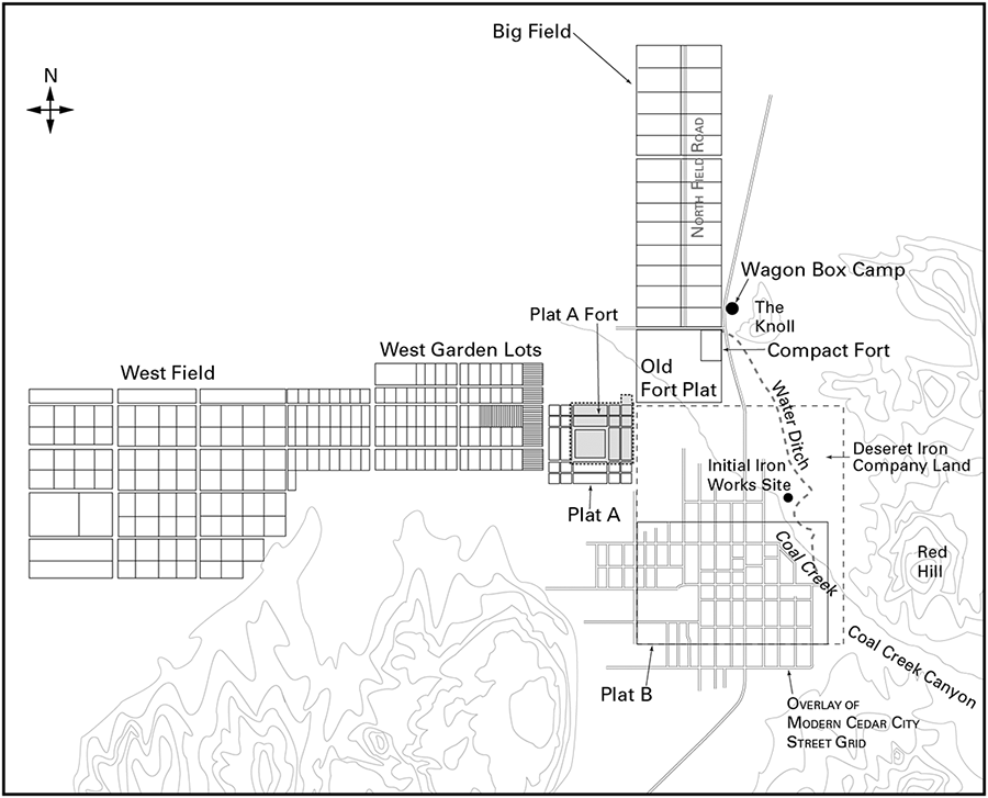
The primary sources themselves provide key information on the new settlement’s chronology. Of first interest is distinguishing between Wagon-Box Camp and Compact Fort. We know that William Dame surveyed land at the Coal Creek site for a fort and corral on either 3 or 4 November 1851. The resulting survey map apparently no longer exists. What has survived is a composite map, dated 1853–1854 in Dame’s own hand, which includes information from the 1851–1852 surveys. This composite resides in the Iron County Recorder’s Office, Parowan, Utah. Its two sections are drawn on the light, blue-lined stationery common to the period. At a later date the sections were mounted on a sheet of heavier paper, using wet glue. As the glue dried, the lighter paper wrinkled. The resulting wrinkles, faded ink and blue paper have made photographic reproduction difficult. Illustration 7-3 is a further composite of Dame’s survey maps, underlaid with a modern aerial photograph of the Cedar City locale.7
Notice that the Knoll, north of the modern city, is visible toward the upper right, with the Wagon-Box Camp labeled nearby. To the left of these lies a rectangle enclosing individual planting lots, the whole called the “Big Field.” Northwest of the Big Field is an area known as “The Cottonwoods” (not shown on illus. 7-3) which became a significant source of house logs for the settlers. Directly south of the Big Field is a square marked “Old Fort Plat.” The “Compact Fort” site is shown in its northeast quadrant, as is Coal Creek, running through its southwest quadrant. Since “old fort” is used indiscriminately throughout both historical and modern records to refer to one or more locations during the first five or six years of Cedar City’s existence, we have chosen to abandon that term and use “Compact Fort” to identify the second place of habitation—and first true townsite—on Coal Creek.
Illus. 7-3. Composite of Dame’s 1851 to 1854 Cedar City surveys with additional topographic and layout details.
James Whittaker Sr., upon arriving at the settlement, first records laboring on a corral. Protecting valuable livestock was high among the settlers’ priorities. The very day after his arrival, 13 November, Whittaker works on the corral; again on the 14th and 15th; breaking for Sunday, the 16th; and again on Monday through Wednesday, 17–19 November. On the 20th he reports that “a few men went for a . . . few more pickets to finish the carrell.”8 Bulloch indicates that the men hauled dry logs from “large groves of trees (cotton wood) about three miles from our camp,” a statement verified by Chatterley.9 These references could be taken to refer to wood for the temporary corral that must have existed in some form at the Wagon-Box Camp. However, additional quotes from John Chatterley and David Bulloch show that the corral being discussed is actually the larger structure built along the south line of the surveyed Compact Fort site.
John Chatterley’s “History of Cedar City” records that, immediately after arrival, “the site of the Fort was looked over, which had been surveyed. . . . As future history will show[,] the first structure built was a public corral built at the south end of the Fort, the only opening was at the North and opening into the fort.”10 In his “Life Sketch,” Bulloch mentions this south side corral as well as memories of the first house built at the townsite: “A fort had been planned and this meeting house was located on the east line of the fort. The cattle corral was on the south side and the public gate was on the north line.” According to Bulloch, the stockade corral was “built of driftwood as there was plenty of it on the creek banks.”11 This comment about driftwood construction underscores the corral’s southern location, because it indicates the enclosure was not far from the banks of Coal Creek, flowing across the southwest corner of the Old Fort plat.
House-Building in the Compact Fort
Understanding the corral position helps clarify journal references to the house-building that was soon to take place. It also helps chronicle, by showing first moves onto the Compact Fort site, the steady abandonment of the Wagon-Box Camp for more permanent dwellings. On 24 November, as James Whittaker Sr. reports, “The People moved their waggons on the South Side Carrell.”12 From this point on, the Wagon-Box Camp slowly disappears, as each wagon is moved from there to the corral and from the corral, eventually, to its owner’s new house lot, somewhere along the perimeter of the yet-to-be-enclosed fort. But the first day was spent, Whittaker recalls, with men and wagons jostled up close to the wall of the corral, “making it comfortable round the waggons with cedars to keep the wind from blowing on them while sitting round their little fires.”13
On 26 November, Henry Lunt informed the men they could begin cutting logs for their own houses the next day. A week earlier, the settlers had expressed their discontent with the presiding elder, Matthew Carruthers, for hiring Lorenzo Barton to cut logs for a house for Carruthers while everyone else was required to work on the public corral. Their irritation eventually waned. Whittaker records cutting the logs for his own house between 27 November and 8 December, while from 9 to 16 December he and a neighbor, William Slack, took turns helping each other build their new homes.14 Christmas was marked only by the terse entry “Worked at the house—very cold day snow & sleet,” suggesting both how busy and how tired Whittaker was. The following Saturday’s entry noted a small yet important milestone: “Worked at house. Removed waggon to the house.” Occurring 45 days after Whittaker arrived in Cedar City, this move severed his last ties to the Wagon-Box Camp and documented his shift to the Compact Fort.15
Although no portions of the Compact Fort survive, contemporary descriptions exist. Chatterley recalls that “The houses were built along the outer wall of the Fort, and the spaces between the houses were built up with logs, chunked and daubed with mud, so it formed a solid wall about 8 feet high.”16 Picket wood, much lighter than the solid building logs, would generally be placed between houses, closing any gaps in the fort wall. An article in the Millennial Star of 6 January 1855, reviewing iron manufacturing in Utah, describes this construction as “put up in the form of a fort, with the intervals between the houses picketed, to serve the purposes of defence.”17
While house logs were cut to roughly standard sizes large enough for cabin walls (see related sidebar and illustrations), almost any type and size of lumber could be used as a picket—driftwood (as Bulloch wrote), saplings, deadwood and so forth. These could be driven into the ground between houses, filled in with brush and finally daubed with mud. Insight into the process comes from a notation on William Palmer’s second sketch, entitled “1st Fort at Cedar City,” made during his interview with David Bulloch (see illus. 7-8). The note reads: “Dobie Walls between the houses,” suggesting that the pickets set up as defensive barriers between the houses were coated with mud which, when dry, had the appearance of adobe. Chatterley’s reference to “chunked and daubed” logs furthers the idea that mud was used as an insulator to protect settlers from the cold wind as well as from any stray arrows. Palmer’s second sketch confirms Chatterley’s and Bulloch’s descriptions, noted earlier, of the fort configuration: the corral abutted the Compact Fort on the south, with a gate cut into their shared wall. Illustration 7-8 clearly shows houses built next to (or into) the outer walls of the Compact Fort.18
Features of the Compact Fort: Bastion and Meetinghouse
As a protective measure, the pioneers erected bastions (guardhouses) “on each side of the fort.”19 No information survives to suggest how these bastions were incorporated into the fort design. While they could have been set midway on the east and west walls, they were probably—if the settlers followed the Parowan model—built on the corners, perhaps one on the northeast corner of the fort and the other on the southwest corner of the corral. With the bastions in place, as Chatterley explains, the continuous guard duty begun at the time of the Wagon-Box Camp became more formal.
In three weeks after settling the Fort there was a large Company of Scotch and some others, near 50 people joined the emigrants, so that guarding was a little easier, as every man had to take his turn, the writer was only 16 years of age, and he with other boys had to take their turn at guarding the same as the men. The men and boys were organized as a part of the Nauvoo Legion, and 15 of us had to go to the bastion, which was built after the public corrall was built. The nights were divided into 3 watches, 5 men on at a time with a captain of the guard, if the guards caught anyone outside the Fort, they were taken to the guard house (bastion) and kept there, some till morning, some only, until the captain of the guard would let them go.20
Among the most historically interesting buildings constructed in the Compact Fort was that known variously as “Bro. Ross’ house,” the “meeting house” and the “school house.” This large cabin had originally been a double-size log structure belonging to, and probably built by, the Ross brothers, Alexander, Daniel and Duncan. As noted earlier, David Bulloch recalled this cabin as the first house built in the surveyed Compact Fort site, set on its east line. William Palmer’s second sketch, made following his interview with David Bulloch, also puts the meetinghouse on the east side of the fort (see illus. 7-8). Whether it was the first structure built after the “South Side Carrell” is debatable, but that is unimportant to its later history. John Chatterley sets up the story in a useful, if not totally accurate, comment in his “History of Cedar City”:
In Spring of 1852 the Ross Bros, Alexander, Daniel and Duncan after putting in their crops, concluded to leave as Aleck and Duncan did not like farming, so they sold their whole possesions to Joseph Chatterley, house with two large rooms and 84 acres of land. Bro. Chatterley had the petition cut out of the hous and fitted it up for schools and religious services of cour[s]e he was assisted by the brethren to make seats, and desks for the day school. Elder Matthew Carruthers was the Presiding Elder, he also taught the day school until he was called to superintend the construction of the Iron Works, which were started that summer (1852) when called away John Chatterley was placed in the school as teacher.21
As noted in chapter 6, Duncan Ross could not have left at this time because he was, unfortunately, one of the three men identified by Whittaker in his 3 March journal entry as having been killed by Indians. Duncan and his friends, James Baird and John Lowe, had made the acquaintance of the “Co of Spaniards” passing through the area on their way to California; on 14 February the three left Cedar City and joined this party on its trek south. No comment is made concerning the fate of the Spaniards and no specifics are offered as to when or how the group was attacked. Nevertheless, Whittaker’s 3 March reference tell us that Amon, one of the more friendly and communicative of the local Indians, reported the deaths of the three men to the settlers.
This must have left Alexander, Daniel and their unnamed sister badly shaken. On Monday, 28 June 1852, the remaining Ross siblings gave up their southern Utah property, left “contrary to council” and joined Wiley’s party for Salt Lake City. Joseph Chatterley would have bought the home at this time. This transaction is strongly implied by both Lunt and Whittaker because, after this date, the building is never referred to again as “Bro. Ross’ house,” but only as “the meeting house” or “the school house.”22
The Size of the Compact Fort
There are various reports on the size of the fort. Charles Willden said, when he arrived in Cedar City on 29 October 1852, almost a year into settlement life, that “the settlers were building their log houses in the form of a 100 yard square fort with a stockade, and assembly court and a Liberty pole in the center.”23 Since Dame surveyed the Old Fort Plat At 160 rods (880 yards) wide, the fort that Willden remembered occupied only about an eighth of the total area surveyed for that site. John Lee Jones, son of iron worker John Pidding Jones, gives an even smaller size for the Compact Fort:
In the Spring of 1853, March 15th, we proceeded On our Journey to “Iron Co”, w[h]ere we arrived April 2nd, this Place was then Called “Coal Creek”, here we found a Small Fort about 20 Rods Long by 10 Rods Wide. on each Side of this Fort Log House[s] were Built & on one End Pickets were Placed in the Ground on there Ends. & a Large Gate Swung in the Center, This Was an entrance & Ingress. on the Opposite End there was a Large Corral. in w[h]ich all the Stock was placed every Night. to preserve them from the Attacks of the Lamanit[e]s.24
This rectangular size translates as 55 by 110 yards, just slightly larger than the playing area of a football field, which is about half as wide as Willden’s recollection. George Bowering provides the only first-hand account. His journal entry on 2 May 1853 records arriving at a “small Fort of some 12 or 20 houses forted in with two big doors at the north end.”25 Perhaps the simplest way of reconciling these various references is to suggest that the basic Compact Fort survey shape was a square but that the addition of the “South-Side Carrell” changed it into a rectangle, as shown on William Palmer’s second sketch (illus. 7-8).
“Ditched ’till Noon”: Providing Water for the Community
After the initial survey, early in November 1851, and the building of the protective corral at the south end of the Compact Fort, the settlers had to build a ditch to divert the water of Coal Creek for irrigation. No settlement could survive without an ample supply of accessible water. Dame undoubtedly surveyed a route for water ditches between Coal Creek and the fort site, although Whittaker, on 19 November, gives Lunt and Chatterley credit for it.26 The fact that on 20 November, within 10 days of their arrival, the settlers began work on the ditch also suggests that Dame had included it in his initial planning. Evidently it began some distance upstream, in this case south and east of the settlement (up Coal Creek Canyon).27 As David Bulloch remembers, “After making our camp a ditch was taken out of Coal Creek. This first ditch was taken out just a little below where our present dam is. This ditch carried the water to within a few rods of the camp along the line of wagons.”28 This means the Big Field was watered by a ditch that ran from the mouth of the canyon northward along the foothills and then continued around to the foot of the Knoll (see illus. 7–3).
The dam Bulloch mentions was probably one near the mill site built later in the mouth of Coal Creek Canyon. This would place the dam between the southern tip of Red Hill29 and the ridge of gray shale to the west of it. The ditch may have entered the settlement area just west of the Knoll, somewhere near the current KOA campground (1121 North Main Street). Possibly the stream may have been divided by the pioneers, with one branch eventually providing water for fields west of the Compact Fort and the other routing along the east side of the fort to the garden area and Big Field. The total distance of this route, which seems very feasible, may have been over a mile and a half. Taking water out further downstream would have required the settlers to contour the ditch over or around the east side of the slight rise where the present cemetery is located. However, water could have been taken out below or near the cemetery and routed to fields west of the fort site, as is done today.
The settlers began a second ditch early in 1852. Henry Lunt recorded on 4 February 1852 that “Myself br’s Wiley and Bosnell looked out a place for takeing out the water out of Coal Creek to irregate the field.”30 Both ditches were in use that first planting season. On 19 April, Lunt mentions “ditches” in his diary; on 21 May the “lower” dam washed out; and the next day the “upper” ditch broke as well. Lunt used his characteristic good humor to handle the frustration, noting merely that because the spate of water “came across my lot . . . I spent some of the afternoon in watering my wheat.” Lunt inspected the ditches on 11 June and found them in very bad condition. But by 27 June he thought the men were making progress on repairs. On that date he writes a letter to the Deseret News describing the problem:
The water ditch that supplies the upper part of our field has been very troublesome, owing to it washing in some places so tremendously, and again filling other places up with sand that it washed over; a great amount of labor has been spent over it, and it is now doing much better.31
But a heavy storm blasted the area on 16 July, striking east of the Compact Fort. Lunt himself was up in the “Kanyon” when it hit there with “tremendeous Thunder and lightning and heavy rain. . . . Rained down in the valley tremondeous for about two hours, commenced about 11 oclock. The water was 12 inches deep in some of the houses and cellars in the Fort.”32 This storm surely struck the sandy area of the upper water ditch. As Lunt notes, in mounting frustration, both dams washed out on 20 July, 29 July and 7 August.33
Two ditches were needed to adequately irrigate all the lots in the Big Field and still supply domestic water to the growing number of homes in the Compact Fort. On 30 July, with both dams out, “the Bishop called the brethren together in the morning for the purpose of fixing the dams in the Creek again, but because the Iron men did not go to help them they would not go, and we have now to pack our water from the Big Creek. Thunder and rain in the evening.”34 Lunt is still noting ditch repair and expansion problems in February 1853, while George Bowering records serious flood damage to the iron works, bridges and dams the following September.35 Obviously, maintaining a safe and adequate water system demanded more than its share of time and energy during Cedar City’s first uncertain years.
Surveying the Big Field
The destination for much of the water diverted into the two new ditches was the Big Field, the first major planting site of the Coal Creek settlement. As in Parowan, settlers planned to live inside the community or fort and have their farms on the perimeter. The Big Field, however, was presumably not surveyed until after the settlers arrived. We can infer this because neither George A. Smith nor Henry Lunt mentions it as a part of the initial survey.36 Whittaker records helping Dame “to survey the field” on 23 and 24 December.37 Most likely, this is the formal survey of the Big Field, covering approximately 500 acres, laid out in 10- and 20-acre plots north of the Compact Fort and corral.
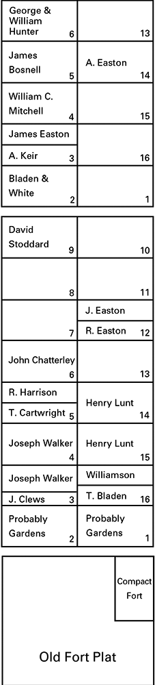
Other surveys may have been taken after 4 November and before 23 December. Deed Book A in the Iron County Recorder’s Office shows that on 19 December, four days prior to anyone else filing for a lot, Henry Lunt and Robert Wiley claimed property located in Ranges 3 and 5 (for which no map is available), paid their filing fees and presumably received a description of the property. William C. Mitchell, Thomas Cartwright and Richard Harrison paid their fees on 23 December.38 They could not have done this unless the lots had already been surveyed. Illustration -9 shows those who recorded their property in the Big Field between 19 December 1851 and 14 September 1852. For some reason, the great majority of lots in the Big Field were not recorded until the latter date, almost nine months after the first five were filed. No reason is known for this large gap in time.
Illus. 7-9. Big Field and Compact Fort layout, with lot owners, from William H. Dame’s 1853–54 survey.
The Big Field was half a mile in width (Dame’s survey figure is 160 rods) and 1.6 miles long. Although the leaders advised the settlers to take no more than 10 acres, the Big Field contained 26 lots of 20 acres (40 by 80 rods each; some were divided). In most of Dame’s other surveys, the 10-acre lots are square: 40 by 40 rods. A scan of the Big Field area today reveals lots that are also mostly 10 acres each, 40 by 40 rods square.
According to Chatterley, the Big Field was laid out in blocks and the lots drawn. Some settlers received 10 acres and a few 20. Each man also got a one-acre lot on the south end of the Big Field to raise “garden truck for summer use” and vegetables for winter. As Whittaker notes on 17 March 1852, “Fine day, worked in the garden. Planted turnips, beets, onions, sowed some radishes, lettuce, onions.”39 (Onions must have been a valued seasoning, providing a little flavor to the often-bland pioneer fare.) There were also smaller plots, “close to the Fort,” laid off for “flowers, melons, and etc.”40
A lane, running north and south, with 20-acre lots on either side, divided the Big Field. Lanes also ran laterally between each set of lots. The remains of some of these lanes are still visible today. Many residents assume that North Field Road, running north and south, is the center lane dividing Dame’s Big Field survey, but this is not the case. According to measurements made by the authors, the east side of present North Field Road is 111 feet east of Dame’s center lane (see illus. 7-3).41
Why the inconsistency in measurement? Cedar City property owner Alex Rollo suggested that the present North Field Road was once the bottom of a flood channel which carried overflow waters northward to avoid inundating the fields. This, he felt, became the physical dividing line, rather than Dame’s surveyed center line. Another possibility is that, after a new township survey occurred in the early 1870s, property lines were shifted to more closely match subdivision section lines. The abandonment of the Compact Fort (including the roads or lands surrounding it) and its subsequent absorption into current fields no doubt contributed to the problem. Taking into consideration these minor adjustments, illustration 7-3 shows the location of the Big Field in relation to other pioneer settlement features shown on Dame’s survey.
Curiously, entries in the deed books mentioning the Big Field show that some farm lots were in Ranges 2E and 5NW, but these do not appear on Dame’s survey. They would have been out near The Cottonwoods, some three to four miles west of Cedar City. Since alfalfa had not yet been introduced to Utah, this land would have been valuable as a rare source of storable feed for the cattle. It probably became communal property as, evidently, everyone harvested hay from it. There are several references to hay meadows, including a particularly vivid pair of entries made by Lunt regarding Alexander “Sandy” Keir and James Bosnell:
Monday Oct. 18. 1852 Fine day. Mowed hay in the meadow Windy day. A fire broke out on the meadow from a little fire that was made on Saturday by Br. Keir lighting his pipe; it burned the Grass very furiously, the wind was very high, and it increased so rapidly that it appeared as though it would soon burn the whole of the Hay in the meadow, there was a large stack belonging to Br. Bosnell and also several other small stacks of hay in the meadow The fire was progressing rappidly towards Br Bosnell’s stack. I fell on my knees and asked my Heave[n]ly Father to cause that the fire might stay its rageing and distruction, immediately on my rising up the fire seemed to stay its rageing and by my exertions for about two hours I succeeded in putting the whole of it out.
Tuesday October 19 1852 Fine day. Strong South wind. Mowed 2 loads of hay. Br Bosnell came to me in the morning, and said he was very much obliged to me for saving his stack of hay and said he would not promise if he should reward me any for my trouble. This afternoon the fire broke out again and Burnt Bosnell’s stack of hay down to the ground and also a considerable quantity of grass.42
While the humorous aspects of this account will be apparent to the modern reader, it is all too easy to forget today how threatening the loss of a hay crop could be to a pioneer community. One can hope James Bosnell learned a lesson in humility and gratitude, but it would have been a costly one indeed if the price had been the destruction of the whole meadow and the burning of a precious food source on which the settlement’s livestock depended. Without their animals, the pioneers would have been unable to travel, except on foot, and plowing and planting would have been nearly impossible. Lunt would have seen the rescue of the crop neither as a nuisance nor as an opportunity for personal heroics, but rather as an absolute necessity.
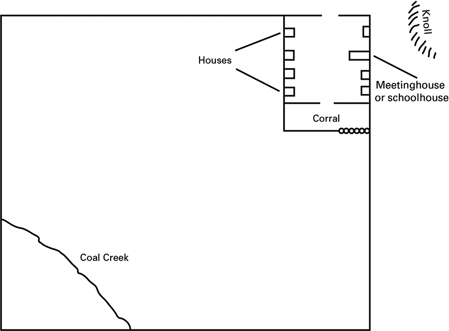
Many of the arguments used to locate the Big Field are also relevant in locating the site of the Compact Fort. Most people accept Dame’s survey evidence, which shows the fort site slightly southwest of the Knoll. The most likely placement of the Compact Fort itself was in the northeast corner of the Old Fort plat. Palmer created a third sketch during his interview with David Bulloch that indicates this: basically, a mere outline of the fort site with a smaller segment drawn in at the northeast (upper right) corner (see illus. 7-10).
Illus. 7-10. Diagram based on William Palmer’s sketch of the Coal Creek survey site: the third of three drawings made by Palmer during interviews with David Bulloch, ca. 1928.
There is some evidence that one of the first houses built against the inside of the first fort wall was still in use 50 years later. It was owned by Andrew Jensen (not the historian Andrew Jenson) and stood near the present willow-lined North Field ditch, directly west of the point of the Knoll.43 Some of the older generation still in Cedar City claim to have seen the “old Andrew Jensen home” standing just west of the irrigation canal behind the Southern Utah Animal Hospital and believe it was positioned just inside the old fort.
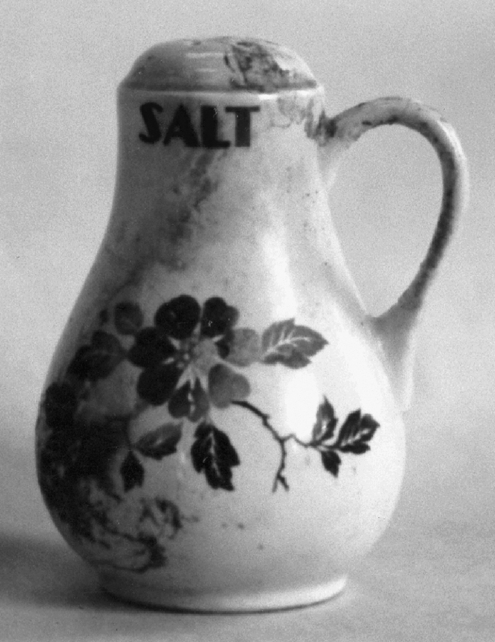
Charles R. Hunter related that as a boy he rode by this site many times, passing from the family farm northwest of Cedar City on his way to school and back. He remembered seeing old fruit trees and pieces of broken glass and other artifacts near the west bank of the irrigation ditch. He firmly believed the east line of the Compact Fort paralleled the west side of the canal.44 Hunter is not alone in having turned up artifacts. A small piece of history—an unbroken salt shaker—was unearthed by Galen Allred in the early 1970s while excavating a sewer ditch with a backhoe for the Southern Utah Animal Hospital (see illus. 7-11). According to members of the Southern Utah University Art Department, its material, design, artwork and firing techniques are characteristic of pieces made in England in the middle 1800s.
Illus. 7-11. Pioneer salt shaker found by Galen Allred in the early 1970s near Compact Fort site. Photograph by Morris A. Shirts.
Fencing the Big Field
As in Parowan, the Big Field for the Compact Fort settlers had to be fenced to protect it from roaming horses and cattle and from passing wagon train livestock. In the spring, new grain lured cattle to the field, so increased watchfulness was required. James Whittaker notes a community decision in his journal entry of 20 March 1852: “Attended a quorum meeting in the evening at Bro. Ross House Agreed to herd the Cattle in turns.”45 Rotating these duties among all the men, however, soon became too awkward to manage. Taking a new approach, Lunt convened another general discussion on 5 April to appoint one man to do the herding: “Called a meeting of the Brethren in the Centre of the fort in the Evening about herding the Cattle. Bro. Williams agreed to herd, and be paid in wheat at Tithing prices.” Two days later, Lunt penned a hopeful note, “Williams commenced herding the Cattle.” But the very next day, 8 April, the problem was back in his hands: “Williams gave up the herd last evening, he did not inform me of it. This morning I was fetched out of the field to see to sending some one wi[th] the herd.”46
Entries reporting varied success and failure at managing the livestock continue into the summer and beyond. At the very least, such records make it clear that reconciling the ongoing conflict between raising vital crops and protecting them from livestock whose natural instinct was to eat them occupied a central role in pioneer life.47
Fencing the Big Field caused nearly as much trouble for the settlers as herding the cattle. However, there was a crucial difference: the Big Field posed a finite problem that could, with enough commitment and determination, be solved. Lunt’s diary entries refer to both “water ditches” and “ditches.” The first, of course, carried water. The second usually refers to a method of fencing that was employed both between pioneer homes and around the Big Field.
Pioneer fence-building involved digging a ditch two or three feet deep with steep-sloping sides, approximating a V-shape. Cedar posts were set at needed intervals into the ditch bottom, connected by a single long pole or rail. Brush and various-sized tree limbs lined the bottom of the ditch between the posts and the pole, to discourage small animals like sheep or calves from breaking through. The rail height and deep, sloped ditch made it difficult for larger animals to cross over, even if they did attempt to push through the fence. The total length required to enclose the Big Field would have been nearly 22,400 feet or over four miles. Without modern materials or fence-making tools, having to rely solely on muscle power, the settlers came to see this task as one of their most back-breaking and unwelcome duties.
The Big Field was still fenced in 1870 when surveyor Joseph Gorlinski mapped the area. At that time, the field included more than the 500 acres described in contemporary journals. Perhaps some acreage was added after Dame’s initial survey to accommodate a growing population. Gorlinski’s survey shows the southeast corner of the Big Field west and slightly north of the Knoll, about where pioneer accounts had placed it.48
Domestic Life in the Settlements
Social aspects of southern Utah pioneer life appear in snippets of information culled from journal entries, which usually record the more immediate demands of creating a safe and productive colony. Henry Lunt is particularly negligent in recording the little household descriptions and family anecdotes that bring settlement history to life, but this is entirely understandable given the drain on his time and energy as leader of a people who literally depended on him for their lives. His father-in-law, James Whittaker, provides domestic details a little more frequently, but often in the sparsest of prose. For example, he tells us on 10 March 1852 that he ditched until noon and then “commenced to make a table.” On Friday, 12 March, he records what appears to be a companion entry: “Made some forms for seats.” These are the first known comments on furniture making in Cedar City and we can wish that Whittaker had been able to look ahead and see how much his future readers would relish more information. Which wood did he choose for his table and chairs, for instance? Certainly not the softer cedar or cottonwood. The harder lumber choices (in larger widths) were piñon pine or spruce or fir from the mountains. Did he use wood-working tools or merely large or small axes? If he did own tools, did he bring them all the way from Scotland and across the plains to Utah?49
Lunt’s first entry about domestic work occurs on 14 April 1852. Noting that he has already plowed seven acres for James Whittaker, he ends the day’s report by saying, “I worked on the Chicken Coop.” One’s curiosity is immediately aroused. How large was this structure? Was it a true hen house or a smaller roost with latched lid or door? Since wire screening was not yet an option, Lunt’s version may have been made solid on two or three sides with a slatted top or front, too small for the chickens to escape from but airy enough to provide sufficient light and ventilation. Or perhaps it was always intended that the settlement fowl would run free and the coop was only built to provide a night roost for safety against predatory animals.
Ten days later, Whittaker reports working with Lunt: “In the afternoon myself with James helped Bro Lunt to ditch having promised to help him do all his fencing & ditching for a Churn he got made for me & a door & frame.”50 The shape and size of the churn would have been interesting to know—these were often made with iron or copper hoops around the staves, similar to large packing barrels. It seems unusual that the Cedar City pioneers would have wanted to use any of the precious iron pieces already being scavenged off wagon wheels merely to make hoops for a churn. No clues are offered about the door, but almost eight months later, on 10 December, Lunt makes a comment that catches the eye: “Bro Pugmire made me some fastenings for my door and gave them unto me. I feel truly grateful to the brethren for their kindness.”51 Since we know that Jonathan Pugmire was a blacksmith, it might have been, in this case, that scrap iron was used to make the door fastenings. Another possibility is that Pugmire cut two or three fastenings out of trimmed rawhide or leather (ox, cow or deer) and used iron nails to peg each side of each flexible hinge to the proper place on door and frame.
Supplementing Lunt’s and Whittaker’s records, David Bulloch and John Chatterley also comment on the implements of everyday living in a pioneer age. In his “Life Sketch,” Bulloch made note of the kind of weapons used by the settlers, comparing them to Native American weapons:
The only guns we had were the old youger (powder) type. It took sometime to load these as we had no cartriges. We carried our powder in a horn which we hung from our sides. The horns were either cow or ox horns, well cleaned out inside. In the large end was placed a large cork and a very small hole was made in the small end. We filled the horn through the large hole and measured it out carefully through the small hole as powder was scarce and valuable. The powder was measured in a little measuring flask which held just the right amount. It was poured into a shell after which a wad or rag or paper was pressed to prevent the powder from losing out. Then a ball of lead was added.
We were not so quick with our weapons as the red men but we were able to shoot a much longer distance than they were. I remember seeing a two year old heifer come into camp once with an arrow shot through it near the kidneys. The arrow was removed but the animal died as a result of it’s [sic] wound. These and other kinds of minor troubles were frequent but we were blessed in not having any very serious trouble with the Indians.52
Chatterley’s reminiscences contain at least one sentence that sounds like a direct memory from his childhood, a sentiment that every modern child would understand: “It was quite a bit of a trial to have to be deprived of sufficient sweets that was needed to fully enjoy life.” The women of the colony, he reports, “boiled beets, carrots or any other produce that would boil down to a syrup,” pale substitutes for sugar, but welcome as any variation would be to people who made do with the little at hand.
If sweeteners were hard to come by, materials for making soap, at least, were easy to find. Logs from the Cottonwoods, Chatterley reports, were burned to ashes and carried to the settlement, where they were “leeched in a U shaped vat and the liquid from the ashes boiled down with grease and made into soap, which answered very well, but made much labor to obtain it.”
Chatterley recounted a vivid anecdote regarding one of the Ross boys, who left the settlement “contrary to counsel,” not long after the death of his brother Duncan. According to Chatterley, “Daniel Ross, who left in Spring of 1852, but came back with a wife, went barefoot up Shurtz’s [Shirts] canyon for logs to build a house and when he came home during the evening he would lie on his face while his wife picked the slivers out of his feet.” The story ends with a nicely understated comment that “It certainly required courage and patience to build up a settlement.”53
Not every hour of a pioneer’s day, however, was burdened by the drudgeries of unending toil. According to pioneer tradition, the settlers rested from their work on one occasion when Parowan challenged Cedar City to a man-to-man ditch-digging contest. Since the ditch would be located in Parowan, this was a clever move to insure that the results would benefit the Parowan community no matter who dug the most yards. Parowan’s representative was David Ward. Cedar City sent Joseph Walker, an accomplished boxer who stood 6 feet 2 inches and weighed about 220 lbs.
Walker was originally employed in the iron works at Low Moor near Bradford in Yorkshire, England. An energetic and responsible worker, he was sent by his company to Scotland to learn how to operate a power-drive trip hammer. When his arm was crushed in an accident at work, his wife, Betty, who had heard the LDS elders had the power to heal, asked if they would come and bless her husband. Joseph’s arm was restored and Betty was baptized, urging her husband to take their large family to Zion along with other families from the Low Moor iron works. Although not ready to commit to the new religion, Joseph willingly moved with family and friends to a new home in America. Settling on a farm in the Mill Creek area of Salt Lake Valley, Joseph aligned himself with the Latter-day Saints soon after immigrating. In December 1850 he was called to join the iron missionaries.
According to tradition, the Parowan–Cedar City ditch-digging contest started early one morning with the crack of a pistol and continued until the noon meal. After eating, the contest resumed. Within a couple of hours, Walker had taken a substantial lead. By 4:00 p.m., David Ward threw down his shovel and acknowledged defeat. Then, as Palmer puts it, “Parowan cheerfully gave the supper and dance and in good sportsmanship credited Walker with digging enough ditch that they had to pay for it.”54
On the whole, the iron missionaries faced life in the harsh southern Utah terrain by sharing the goal of creating a Zion community. These spiritual expectations allowed them to keep things in perspective—including the things they lacked—and provided an excellent rationale for playing as hard as they worked. Whittaker’s description of the wedding of his daughter Ellen (see illus. 7-12) to Henry Lunt on 25 March 1852 beautifully illustrates the colonists’ willingness to celebrate fully whatever deserved to be celebrated at all:
Thursday March 25th 1852. Morning rather dull. hailstones after dinner, and a beautiful evening My daughter Ellen was married to Bro. Henry Lunt, myself James and Mary with several others attended the Wedding at twenty minutes to seven we left Cedar City for Parowan, in two carriages one drawn by Four horses, the other by two. as we started a Salute was fired with guns. which echoed through the Mountains and the City had the appearince of a joyfull morn, by the inhabitants being collected together to see us set off. and giving us three Cheers as we Started. . . . We arrived at Parowan at twenty minutes past nine o.clock distance twenty miles We were met at the carriages by Pres John L Smith and invited us into his house.
They were married at ¼ to twelve by Bishop Lewis. Before the Ceremony we sung the 40th hymn and after it “Redeemer of Israel.” after Marriage they were blessed by the Brethren with the richest of Heavens blessings. I breakfasted with Bro John D. Lee’s, And left Parowan accompanied by another Carriage containing Pres. John L Smith, Bishop Lewis, John D Lee, and 4 Ladies. Arrived at Cedar City at 4 o clock when our ears were deafened with the cheering of the Saints and firing of guns when we arrived at the Assembly rooms there was a sumptuois feast prepared for about 150 persons.
After dinner a number of the Brethren were amusing themselves in the centre of the Fort by running races jumping &c. Shortly after Dancing commenced and was continued until four o clock in the morning, a great variety of Songs were sung, and several Comic pieces performed. Joy and gladness seemed to be in every countenance. I never saw a party that enjoyed themselves like unto this, such order and a oneness of Spirit prevailed throughout the whole evenings entertainment. The horses in the carriages had rosetes in their bridles and white ribbons attached thereto Some 12 inches long, which added to the appearance of the fine prancing Animals.55
The iron missionaries had moved from the Wagon-Box Camp to a more substantial fort and improved that structure with bastions and a meetinghouse. They had laid the agricultural foundation for a second community and added domestic refinements to life on the frontier. With such an auspicious beginning, the colonists must have imagined sturdy homes, rich harvests and a flourishing iron industry merely a few months away.
Sidebar 7-1: Pioneer House-Building
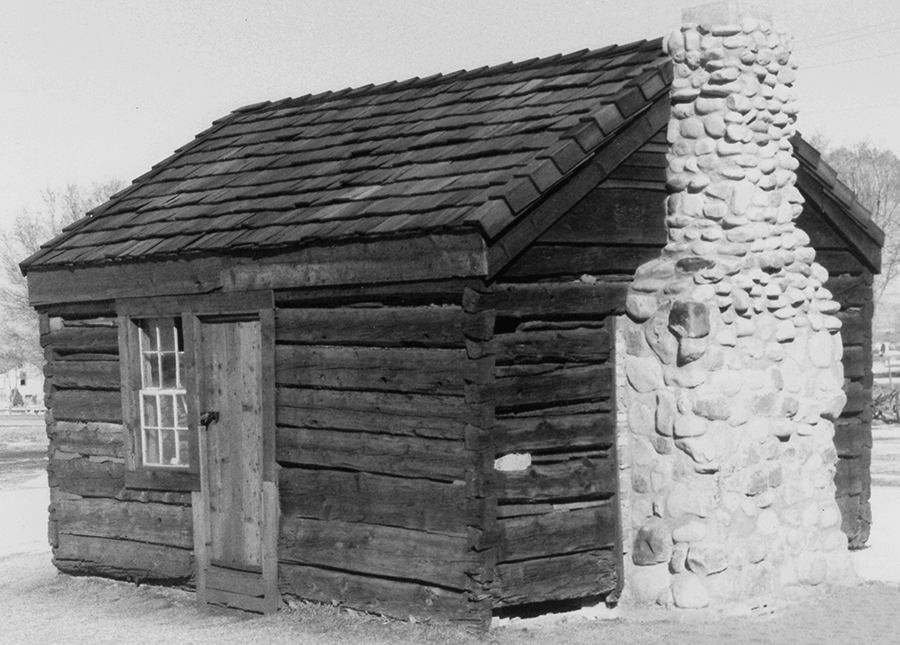
Houses in the early days of settlement were typically small, one-bedroom log cabins with, in many cases, dirt floors. The only log house to survive from this part of Cedar City’s history is the George Wood and Mary Davies Wood home, now in Iron Mission State Park, located at 585 North Main, Cedar City (see illus. 7-4). Wood reportedly built the cabin in 1851 in Parowan, then moved it to Coal Creek, where he placed it in the Compact Fort; he and his wife raised a family of nineteen in it. The house measures 14 by 16 feet and is seven feet high to the square, with a pitched roof. The apex of the gable is about six feet above the square of the house. It has a door in the middle of each side and a window next to one door. One end has a fireplace with a chimney and the other end is plain.
Illus. 7-4. George and Mary Davies Wood cabin as it now appears on the grounds of the Iron Mission State Park, Cedar City, Utah. Photograph by Morris A. Shirts.
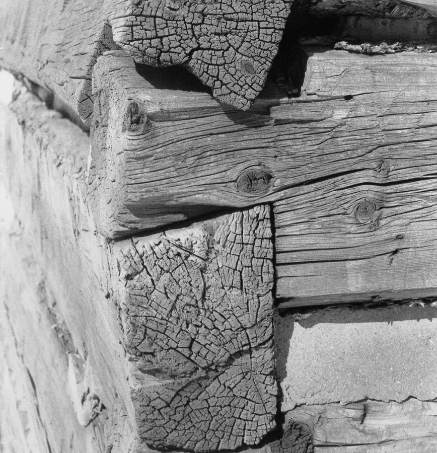
The logs are either spruce or fir (not cottonwood) and have been squared. The corners were dovetailed and the logs fitted closely together, requiring little chinking to make them weather-tight (see illus. 7-5). These details made the structure much sturdier than did the usual notch-and-overlap technique of the time.
Illus. 7-5. Closeup of the dovetail construction of the corners of the George and Mary Davies Wood cabin. Photograph by Morris A. Shirts.
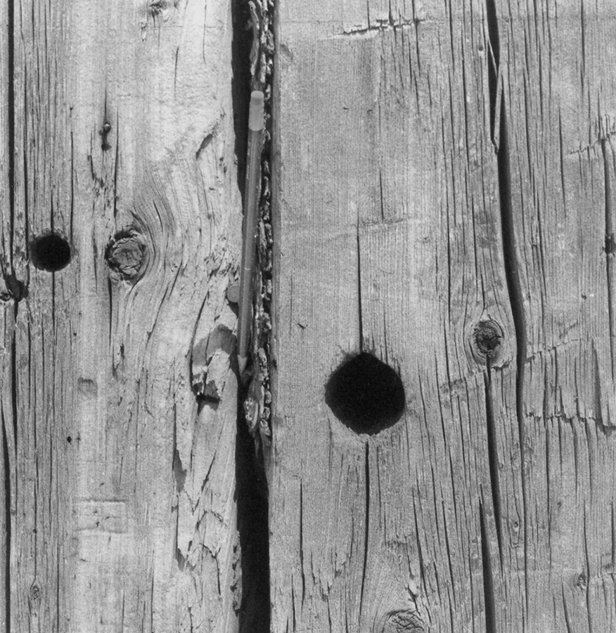
The Wood cabin contains a number of round holes, drilled at random entirely through the logs, that have been the subject of considerable conjecture (see illus. 7-6). The largest is one and a half to two inches in diameter. One is located on the west end (the blank wall without a door or chimney). The east end contains 15 such holes, most of them arranged vertically in a double row near one side of the fireplace chimney. The south side of the house contains 10 holes, one low enough that it could have been a rat hole. These holes seem inappropriately spaced and too small to have served as apertures for firing a gun. One hole on the north side of the cabin, 5 by 7 inches and arched at the top, could have accommodated a stove pipe. Bits of broken pegs remain in several holes, suggesting that perhaps oak pegs were driven through to provide hangers both inside and outside the walls. Another possibility, especially in light of the holes placed near the chimney, is that they were used for ventilation.
Illus. 7-6. Closeup of randomly sized holes drilled through walls of George and Mary Davies Wood cabin. Photograph by Morris A. Shirts.
Wood relocated the house each time Cedar City shifted its boundaries. Eventually, on 11 May 1927, the family donated it to the Daughters of Utah Pioneers, who moved it from the Wood property on Main Street and Fourth North to Cedar City Park, furnished it authentically and maintained it until 29 April 1983. At that time, the DUP was forced to abandon the cabin due to vandalism and lack of finances. Its last move was from Cedar City Park to the grounds of Iron Mission State Park, where it is now maintained.
Like the Wood cabin, the John Pidding Jones cabin was originally constructed in the Compact Fort. Jones arrived in April 1853 and he also dismantled and moved his home several times. At one time, the cabin stood near the intersection of First West and Center Street in Cedar City. In 1875 it was moved for the last time to Enoch, adjacent to Cedar City on the north, where it was a family residence until 1935 or 1940, when it was destroyed. A surviving photograph (see illus. 7–7) was taken shortly before this. The bottom logs may have been cottonwood and the top logs pine. Both the Jones and Wood cabins had pitched roofs, possibly added after initial construction.
Source: Iron Mission State Park; Bonnie Ellis Pryor to Morris Shirts, interview of 15 Apr 1975, notes in Shirts Collection.
2. In Nov 1981 a monument was erected at the cove to commemorate the Wagon-Box Camp.
3. Lunt, diary, 26 Mar 1852. It is important to remember that George A. Smith had left southern Utah for new duties up north and that John D. Lee had stopped keeping his journal and delegated those duties to James Lewis in Parowan. Those two essential sources of information on the southern Utah settlement process were thus no longer available, at least as far as Cedar City was concerned.
4. William R. Palmer, “Pioneer Fortifications,” Improvement Era 54 (Mar 1951): 148–50, 183–87.
6. Rhoda Matheson Wood, “In the First Fort,” 1, undated typescript of ch. 2, unpublished history of Cedar City, MS in Cedar City Public Library (cited from copy in Shirts Collection).
7. William Dame, “Coal Creek Survey Iron Co. U. T. [Utah Territory], 1853–4,” Old Survey Book, Iron County Recorder’s Office, Parowan, Utah. Above the date in the title the numbers “1–2” have been added, in what appears to be an early hand (prior to the turn of the twentieth century). From this, it would appear that the map includes data from 1851–52 as well as from 1853–54. The upper left corner inscription reads: “Cedar City Surveyed 1852–3[.] Lots 4 rods by 20—½ acre each. 1st Streets East and West[,] North & South 6 rods wide[.] 2d Streets 7 rods each[.] Alleys 3 rods each[.] By Wm H. Dame Iron Co. Surveyor[,] Plat A.”
17. “Manufacture of Iron in Utah,” Millennial Star 17 (6 Jan 1855): 1. The greater portion of this article is taken from the “Report of Erastus Snow and Franklin D. Richards, General Agents and Managers of the Deseret Iron Company,” given at the first General Meeting, Cedar City, 18 Nov 1853. A less polished version, mixed with additional passages and occasional ellipses, comprises the greater part of pp. 17–30 in the Deseret Iron Company minutes. See typescript of “Minute Book of the Deseret Iron Company, 1852.” Original given to LDS Church Historian’s Office on 10 Jun 1937 by William R. Palmer, typescript retained in Palmer Collection, copy in Shirts Collection (hereafter cited as Deseret Iron Company, Minutes).
18. William R. Palmer, “First Forts at Cedar City, as told by David Bulloch,” n.d., n.p., Palmer Collection.
23. Jennie Jensen Hancock, “Biography of Charles Willden, 1806–1883,” typescript, 15 (cited from copy in Shirts Collection provided by Willden Family; a comparable copy, “History and Diary of Charles Willden, Sr.,” typescript, but differently formatted, is in Palmer Collection).
24. John Lee Jones, “Biography of John Lee Jones: Principal Residences: Cedar City and Enoch, Utah; Mission to England,” bound typescript, 8, Perry Special Collections. The term “Lamanit[e]s” that the pioneers applied to Native Americans comes from an ethnic group described in the Book of Mormon.
25. George K. Bowering, journal, 161, original in possession of Bernon Auger, Salt Lake City, copy in LDS Church Archives; restricted by family (cited from photocopied excerpts in Shirts Collection).
27. These directions may seem inaccurate unless one remembers the unusual geography of the region. For a description of the Rim of the Basin, see ch. 3, n. 16.
29. Red Hill, so-named for the color of its sandstone, rises 1,060 ft. to the east of modern-day Cedar City, significantly taller and larger than the Knoll at the base of which the first settlers camped. Because of its distinctive features, Red Hill has become the most significant landmark associated with Cedar City.
31. Ibid., 19 Apr, 21–22 May and 11 Jun 1852; Henry Lunt, letter to editor, 27 Jun 1852, “Interesting [News] from Iron Co.,” published in Deseret News, 24 Jul 1852, 3d unnumbered page.
41. Landowners interviewed in the 1980s complained that their property lines were affected by the discrepancy between the center lane as surveyed by Dame, running up the length of the Big Field, and the location of present-day North Field Road. Jay Allred, who then owned the land in the northeast corner of the Old Fort block, bought 15 acres of land and, after having it surveyed, discovered it was closer to 13 acres, because he was losing the acreage represented by the 111 feet between the old land and the modern road. Karl Keel and Alex Rollo, other property owners, have found similar problems. Cedar City Corporation engineer Matt Bulloch claimed that a four-rod strip, not included in the title abstracts, should belong to the properties that fall on the east side of North Field Road. This strip almost certainly comprises the better part of the disputed acreage. Interviews of Cedar City property owners by Morris Shirts, ca. 1985 (undated notes in Shirts Collection).