We all have images in our minds of the American West, be they the paintings of Frederick Remington, images of handcarts and covered wagons, or the natural geography of water-parched landscapes. In this lecture I want to highlight some important and lasting features of religious life in the early republic as settlers moved westward by using another kind of representation: maps and charts. I have been working on these graphics since I began doing work on religion in the West and began to understand the importance of maps to explorers and missionaries who were discovering the West for themselves in the nineteenth century.
Obviously there are many kinds of images that can give us important information about the past, but maps do this in a particular sort of way. They help us to project ourselves into the world. They are a forecast of hopes and dreams, and are a vision of the world as it ought to be or as we imagine it to be. They also allow us to pay attention to the early republic not simply as a glimpse of a people, but as groups of people who lived in relation to a specific location, to a specific space, and to landscapes filled with sacred meanings.1
I want to focus on the relationships between human beings and this continent to see how religious groups interpreted and interacted with the vast expanse of land that they increasingly claimed. The republic as it was established in the late eighteenth century had become a completely different landscape by 1850—it was a literally a different space, and it had been transformed by the presence of new human communities. There were new challenges and opportunities, and the land itself and people’s projections of themselves onto the land played a role in shaping the future of the republic.
The early nineteenth century witnessed changes in more than landscape, of course. The major religious event of the new republic was the Second Great Awakening, an event that is often caricatured for its extremes of emotional revivalism—the enthusiastic praying, singing, dancing, falling down, and yelling that reportedly overtook participants in camp meetings and churches as they were felled by the power of the Holy Spirit.2 Yet it was the slower and perhaps less sensational kinds of organizational changes in denominations that led ultimately to long-lasting change, particularly in the western parts of the nation. In other words, the revivals of the early republic resulted eventually in well-organized and motivated groups who saw newly opened western lands as a divinely ordained opportunity to build the kingdom right here on earth. In doing so, some of these groups that moved west were among the first to organize and settle western lands. They were far ahead of the federal government and even the more mainstream Protestant groups. Ironically, it was those people who were the outcasts religiously from the East who became the developers of the lands in the West and who ultimately paved the way for the infrastructure to develop later on in the West. These kingdom builders, as I call them, saw the land as both a means and an end. The land itself was sacred. The land itself had value. It was a consecrated holding that served as a physical manifestation of an ongoing relationship with God.
Perceptions of the Western Landscape in Early America
In order to understand the ways in which Americans on the eve of the Revolution were thinking about the landscape, we have to back up a little bit. Prior to the Revolution, the continent itself was more often seen by Euro-American Protestants as an obstacle, not as an opportunity. For the Puritans, the landscape itself was a dark, heathenish, even evil and forbidding land. In fact, in the earliest Puritan settlements, families were compelled to live within the towns. Even if the people worked lands elsewhere, they had to live alongside neighbors in an orderly and compact village. They shared the conviction that where the community is, God is. The Puritans weren’t so sure that God was out there in the dark woods. Compact towns represented a way of preserving social order, obviously, but they also worked to buffer society from the evil influences that lay beyond the bounds of civilization as they knew it. Nathaniel Hawthorne’s Scarlet Letter is a great example of this tendency to see the forest, the symbol for a natural world that was unimproved by Euro-American hands, as the primary location of evil and foreboding. Bad things happened when people strayed off into the woods. The landscape itself was not a romantic image of something to be nurtured, but rather a chaos to be tamed or perhaps to be feared. This image held sway in both Europe and among Protestants in the New World for several centuries.3
Maps and the Development of the West
Not until the opening of more lands right around the time of the founding of the republic and the turn of the nineteenth century did exploration of those forbidding regions to the West begin in earnest. But even the exploration that began at this point, with Lewis and Clark’s expedition being the most well-known example, was actually not intended to explore the land for its own sake. People were searching for something beyond the continent. Lewis and Clark were not seeking to discover the wonders of the wilderness in Nebraska or in South Dakota. They were looking for the Northwest Passage. They were looking for a way out the other side of the land. They were looking to get elsewhere. They were sponsored by merchants and other traders and financiers who for their own economic and political reasons wanted to establish ties with areas on the Pacific. The expedition was a way to find the other end of the continent, but not necessarily a way to explore the interior.4
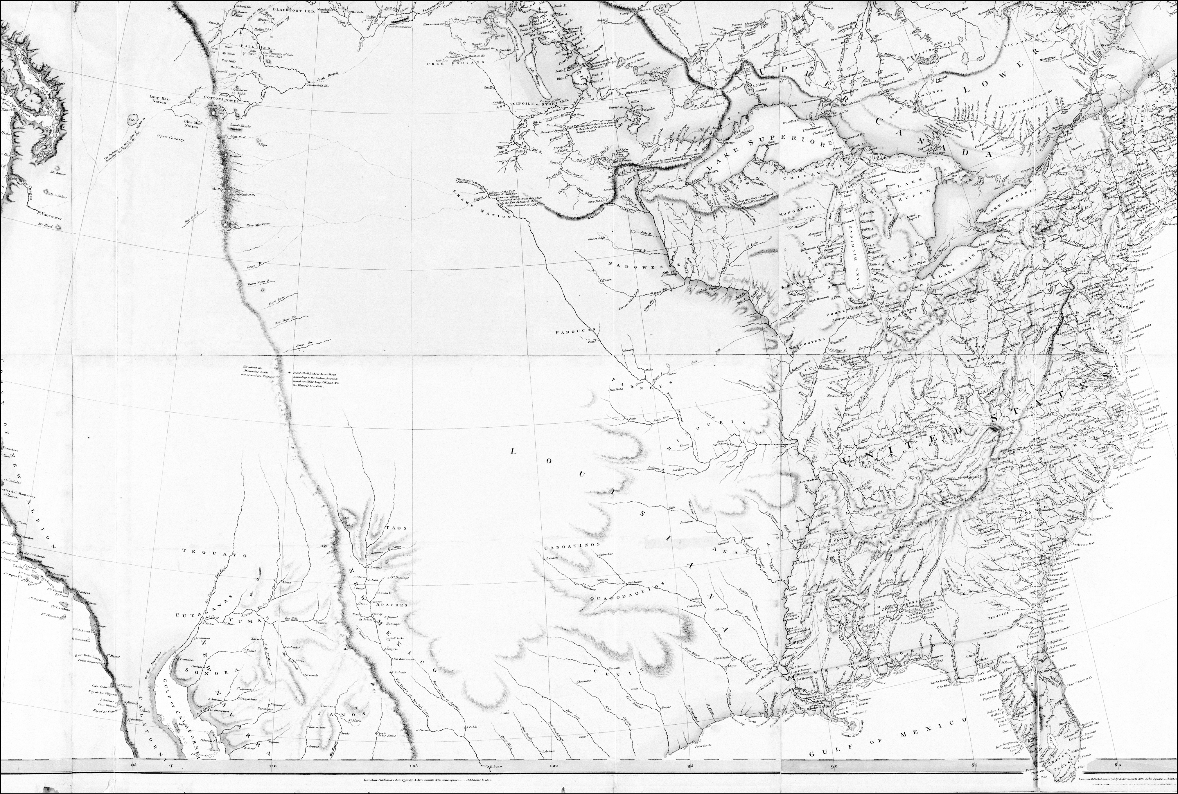
One of the most popular maps of the western part of the United States available around the time that Lewis and Clark began making their journeys was created by Aaron Arrowsmith. Arrowsmith began his career as a surveyor in England. In 1790 he started his own map-publishing firm, and he soon had an international reputation for the maps and atlases that he created. The Hudson’s Bay Company gave him access to the many journals and surveys of western Canada contained in its archives in London, and Arrowsmith printed his first map of North America shortly thereafter, in 1795. He made several revisions between 1795 and 1811. Many things are interesting about it, and many of the details are geographically incorrect.5
Aaron Arrowsmith, “A Map Exhibiting All the New Discoveries in the Interior Parts of North America.” 1795, with additions to 1811. Held at the University of Virginia Library Special Collections. The Arrowsmith map was one of the most important maps of North America during the early republic.
What might strike a contemporary observer, however, is how blank the map is. It reveals, in a single image, how little those Euro-Americans in the eastern part of the new United States knew about the western part of the continent. The Missouri River, for example, is completely off course. There is one single ridge of mountains in the West. The map situates the Great Lake River on the western side of the mountain range and then connects this to the Columbia River with a dotted line. The Arrowsmith map thus supported the incorrect assumption that explorers would encounter a relatively convenient route to the Pacific Ocean. This factual error may well reveal the extent to which our projections of what we would like to see shape our understanding of reality—in turn, these wishful thoughts then change history. Arrowsmith literally created the impression that there was an easy way to get to the Pacific Ocean, and in doing so he opened a door for exploration that eventually produced such a path.
Lewis and Clark, in fact, carried this Arrowsmith map along on their expedition, using it as their authoritative guide. (If you think Map Quest doesn’t work, well, trust me, this was worse.) Arrowsmith’s 1802 map was the most comprehensive map of the West available at this time, and it probably was the most important map that Lewis and Clark used in planning their expedition. Thomas Jefferson owned the 1802 map as well. All of this bespeaks the idea that people were looking to get around the West, to get past it to the other side. For most North Americans of the day, the West itself did not excite interest until sometime later.
Most early maps of the United States, in fact, point to a second reality. The West was not only considered uninteresting in and of itself, but it was also regarded as simply an appendage to the states along the eastern seaboard. Before the various colonies ceded land to the federal government beginning in the 1780s, all of the land to the west of Georgia all the way to the Mississippi River, for example, was considered to be the property of the State of Georgia. Most of the other states had similar boundaries. Colonial authorities simply extended lines due west to the edge of British territory, in order to divide up lands that were not seen to have intrinsic characteristics or value at the time. This demarcation demonstrates the way in which easterners were projecting their own possessions westward—they were seeing themselves projected west.
One of the most dramatic and ultimately the most consequential changes after 1787 that affected religious groups was the gathering and opening of all of these western lands up to the Mississippi as federal territory. The colonies all ceded their western lands to the newly established federal government, and those lands were held thereafter as common land. It was subject to federal jurisdiction, and, therefore, to the laws governing freedom of religion set by the federal government—laws that were decidedly more tolerant than those adhered to by many state governments. This new legal status created considerable ambiguity about what religious freedom was going to look like in those regions—would traditional churches simply move west, or would something new develop? As we’ll see, this geographical and legal opportunity opened the door for religious dissenters to move into western lands.
If this notion of space and landscape was not terrifically important to the federal government in the early years after the founding of the republic, it should also be noted that the notion of America as an ideal of freedom was in many respects removed from the concrete realities of the landscape itself. The idea of freedom was not so much a freedom of place or freedom to be in a certain place. It was a freedom that was vested in the rights of individuals. Similarly, the notion of Manifest Destiny as it emerged in the first decades of the nineteenth century was a political ideal without reference to actual land. It did not contain any specific moral directives about how space should be used, and therefore, it left open the door for a wide variety of opportunities, for new kinds of expression. If America, therefore, had the divine mission to inhabit this continent, that right was an abstract one, formed with little reference to the landscape itself.6
As lands westward began to open for development in the decades after the Revolution, transformation occurred unevenly and in a way that reflected values that often lay beyond the American landscape. Even with the massive territorial expansion of the United States in its early years, the middle of the country was largely ignored. It was the edges that had very important political and economic potential. Again, the middle was just a way to get to other places. California became strategically important, for example, as a gateway to the Pacific world. The Oregon country became important in part for the agricultural value of its land, but also because of its strategic location near the Russians who were coming down from Alaska and the north. Texas, of course, provided an early political buffer from Mexico. But few Americans expressed any sense that the landscape of North America in and of itself was something to be valued. So we have this great donut-shaped approach to development of the country.7
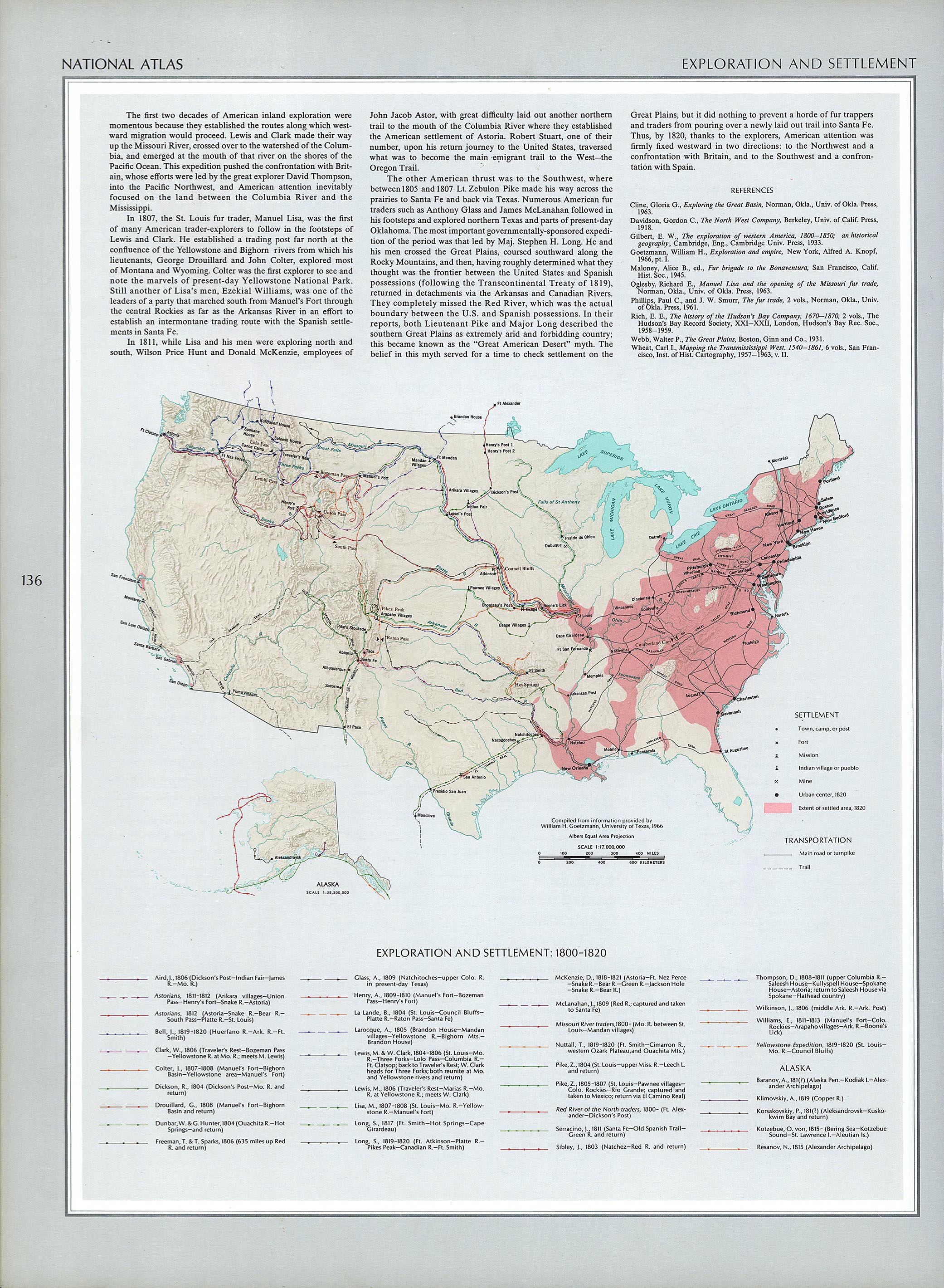
The exploration and settlement of the United States from 1800 to 1820 illustrates this point. All of the early exploration took place with an eye towards getting out and getting across the ocean. The interior, particularly the western half of the country, remained largely undeveloped before about 1820. The routes taken by explorers all tended to be the river routes, which was obviously the easiest way to travel before the introduction of paved roads. The larger point to be made, however, is that the new nation developed unevenly and also strategically, in ways that allowed passage through interior spaces and abundant exit sites.8
Religion and the Landscape
For many reasons, then, the way was clear for outcasts from mainstream society to see value in a landscape where many other Euro-Americans did not. Not all religious believers, of course, saw western regions as sacred. Even for Protestant missionaries who did begin to move westward, the West in the earliest stages was an area to be circumvented on their way to fairer pastures, often the Pacific. Hawaii was the first place that Protestant missionaries looked for outreach. In 1819 and 1820 Protestants left New England and sailed all the way to Hawaii, because they understood it to be a strategic location close to Asia that would allow them some missionary activity. Shortly thereafter the west coast became important for Protestant missionaries. Methodists and Presbyterians both founded missions in the Oregon territory beginning in the mid-1830s and into the 1840s. These were all groups, however, that were pulled along by settlement. They were compelled by the many settlers moving west, so they were reacting to the slow movement of people onto the west coast rather than organizing pro-actively.9
The real evangelistic action, for Protestant missionaries at this time, took place in foreign lands, which were considered ripe for the harvest. One of the biggest foreign missionary associations, the American Board of Commissioners for Foreign Missions (ABCFM), expended much more money sending Protestant missionaries to other countries throughout the world in this time period than in trying to develop the landscape back home. Groups of missionaries traveled to India in 1813, to Sri Lanka in 1816, and to countries all around the Mediterranean in the 1820s and 1830s.10 But again, they expressed much less interest, interestingly, in the North American continent itself. Some missions did reach out to western Native Americans, but relatively few missionaries or resources traveled in that direction.11
Religious Outsiders That Embraced the West
Most people in the United States—Protestant missionaries, the federal government, merchants, and traders—were ignoring the middle of the country at this point. It is no surprise that the first major organizations to see land as an opportunity were religious outcasts, those dissenters who felt that the U.S. government was either actively hostile towards their interests or who simply sought to live out their religious convictions differently. In particular I want to focus on the Shakers, on African American communities, and finally on the Mormons, who represent the most familiar episode. But in fact, there are similarities among all of them not only in terms of their visions of what they wanted to build in the West, but also in terms of the outcome of what they were doing. They were, in large measure, groups who had been the most excluded from the promises of the Revolution and the founding of the republic. Ironically, it was the people left outside of the republican dream, religious dissidents such as Shakers, Mormons, and African Americans (among others) who saw the potential of the landscape itself to become redemptive. The land was sacred ground and would help them build spiritual dreams on the American landscape that would in turn shape the future of the continent and the nation as a whole.
Shakers
The Shakers were a small religious group founded in the 1780s. They came together under the leadership of a charismatic woman named Ann Lee, a British immigrant. Centered in upstate New York in the area that came to be known as the Burned-Over District, the community grew dramatically in the midst of the revivalist furor of the Second Great Awakening. Mother Lee, as she was called, was believed by her followers to be the second incarnation of Jesus Christ. Christ had returned to earth to the United States as a female to convince followers that the millennium had already arrived. Therefore, the job of members of the Shaker community was to build the kingdom and to live in it. All work, all cultivation was consecrated to this purpose of building the kingdom of God right here in the United States. For Shakers, new sets of rules and practices pertained in this kingdom and set Shakers apart from most other Americans of the time. They believed in complete celibacy and a strict division of the sexes. They also engaged in lively dancing and singing as part of their worship.12
The Shakers’ neighbors in New York in the 1790s were not terribly thrilled with the group’s unconventional approach to religion. Facing pressure, Lucy Wright, the successor to Mother Lee, authorized a missionary expedition into the Ohio Valley (which was considered the far west in 1805). This expedition was very successful at finding followers in southern Ohio and Kentucky, where the Shakers founded communities by the late 1820s.13
The Shakers employed a very systematic approach to constructing and establishing new settlements. They developed an extensive communications network to overcome the problems of distance that separated their eastern and their western groups so that they could coordinate better amongst themselves. In other words, the Shakers built an organizational grid that provided one of the first templates for the development of that first frontier. And in fact it was a template that outlasted their own communities. The numbers of Shakers dwindled rather quickly after the turn of the twentieth century. Nonetheless, this area boomed in the wake of some of these early settlements that set the pattern for settlement in its communities. The Shakers demonstrate westward movement instigated by religious dissidents.
African Americans
African Americans are obviously not in and of themselves one religious group. However, there are some similarities in their situation to what we see in the Shaker movement and what we also see among the Mormons. African Americans were also left out of the republican ideal. Although enslaved blacks were gradually freed in the northern states after the establishment of the republic, slavery still was practiced throughout the South.
African Americans, who had converted to Protestant religious traditions in large numbers during the Second Great Awakening, came to understand their plight as analogous to that of Israel. The South, then, became Egypt. African Americans developed a theology based on a reading of the Bible and projected a time when they would move out of Egypt, with the help of a Moses, to Canaan. African Americans sang about and discussed this future promise constantly during the antebellum era. On the one hand, the concept of communal suffering provided many African Americans with a sense of peoplehood. More important for our story, it led them to figure the land itself as sacred: somewhere there was a Canaan that God would preserve for them. Sweet Canaan’s land was not only an idea of freedom for individuals; it was also an actual place.14
Throughout the antebellum period, African Americans talked about and wrote about where that Canaan might be and when they might go there. Some believed that it was Mexico, and several black leaders offered the suggestion that free blacks ought to migrate to Mexico en masse. For a brief period of time in the 1820s, many saw Haiti as the Promised Land. About six thousand African Americans migrated there in the 1820s, but most of them soon realized that it was not the land of freedom and they returned. Many believed Canaan to be Africa, and throughout the nineteenth century, a small number of African Americans lobbied for a collective return to that continent for religious reasons. The colony of Liberia was established in 1820 for African American migrants, and it was regarded by many settlers as a sacred site. Some thought Canaan was in Canada, and the growth of Canada West, an area in Ontario, was again a signal that African Americans were looking for that landscape.
Interestingly, though, many blacks found sacred space in western lands. Several African-American settlements were formed prior to the Civil War by settlers seeking Canaan. By the 1850s, a number of such towns were scattered around the eastern coast, and more developed in the Midwest. The height of the interest came, however, right after the Civil War. Between 1856 and 1915, over sixty predominantly black towns were founded in the Midwest, about a third of them in Oklahoma. This is a story of sacred movement that is not often told. Throughout the West, places like Blackdom, New Mexico; Hobson City, Alabama; Allensworth, California; Rentiesville, Oklahoma; and Mound Bayou, Mississippi, were settled by African Americans who based their migration on the premise that they were going into Canaan.15
Religious organizations moved right along with them. Sometimes, whole church communities picked up and resettled further west. As a result, the major black denominations of the time, the African Methodist Episcopal Church (AME) and the African Methodist Episcopal Zion Church (AMEZ) established churches throughout the western territories. The typical story we hear is that these denominations moved south in order to evangelize the newly freed slaves in the South. This story is true, but they simultaneously moved westward so that states such as Louisiana, Arkansas and Missouri became centers of African American religious life in this period.
Perhaps the most famous of all the Black towns established after the Civil War was a place called Nicodemus. The concept of Nicodemus came from two Black ministers, William Smith and Thomas Harris, both from Clarksville, Tennessee. They went west in the spring of 1877 to look for land. They were joined in that expedition by a man named W. R. Hill, a Kansas land speculator who went back with them to Tennessee after seeing this place out in Kansas. He spread the news among small rural Black churches in Tennessee of a beautiful land, a Canaan, on the south Solomon River in northwestern Kansas. They put up signs that talked about this as the Promised Land for Blacks. It is no wonder, then, that they named the town “Nicodemus,” after the Pharisee to whom Jesus spoke of the importance of being “born again.” Black settlers felt that they might literally be born again in this new place.
The first sixty recruits to Nicodemus arrived in June of 1877. In this new Canaan, African American migrants created a town layout similar in its conception to the early town plans of Puritan New England. Nicodemus was quick to establish its own infrastructure. The First Baptist Church of Nicodemus was organized approximately nine months after the first Black settlers arrived on the Kansas prairie land. In 1879 a sod structure, intended to serve as a church meetinghouse, was partly built over a dugout—revealing something about the conditions in Kansas at that day. By 1880 a small one-room stone sanctuary had been erected at the same site. This structure evolved from limestone to stucco and finally a brick sanctuary was built in 1975.16
Other such communities formed around Nicodemus, and the pace of migration out of the South picked up speed. Probably the most famous participant in this settlement was a man named Benjamin Pap Singleton, who became known as the Moses of the movement. Singleton was a former slave, born in Nashville, Tennessee. Those who followed him came to be known as “Exodusters.” In the late 1860s, Singleton and some of his associates had been urging Blacks to acquire farm land in Tennessee, but Whites wouldn’t sell productive farm land to them, so they had to move further west. As an alternative, Singleton began scouting land in Kansas in the early 1870s. Soon several Black families had migrated from Nashville to Kansas. By 1874, Singleton and his associates has formed the Edgefield Real Estate and Homestead Association in Tennessee, which steered more than twenty thousand Black migrants to Kansas between 1877 and 1879.
The journey west was arduous, which only heightened the sense that it was in fact related to the original Israelite exodus. At the time of the exodus, yellow fever ravaged many river towns in Missouri, Mississippi, and Louisiana. Because many of the Black migrants who stopped over in these towns—they were coming by steamboat, by train or on horseback—were sick and were poverty stricken, city officials assumed that they must be potential disease carriers. This perceived threat caused alarm in cities such as St. Louis, which imposed all kinds of unnecessary quarantine measures to discourage future migrants from crossing that way. The trek, with its hardships, became an exodus of biblical proportions for the participants.
For many African Americans, including the Nicodemus settlers, the western lands represented Canaan. African Americans proceeded to establish self-sustaining communities that represented their vision of equality and spiritual freedom. They also were the first to settle these lands, and they developed the technology and strategies that would become common in this area.
Mormons
As several scholars have observed, Mormonism represents perhaps the archetypal example of the spacialization of religion. The sacred geography of the American West is a central and defining feature of Latter-day Saint identity. It has served to distinguish the Saints as a people almost from the very beginning. What is perhaps less often noticed are the contributions made by The Church of Jesus Christ of Latter-day Saints as an organizational body to the early development of the western United States.
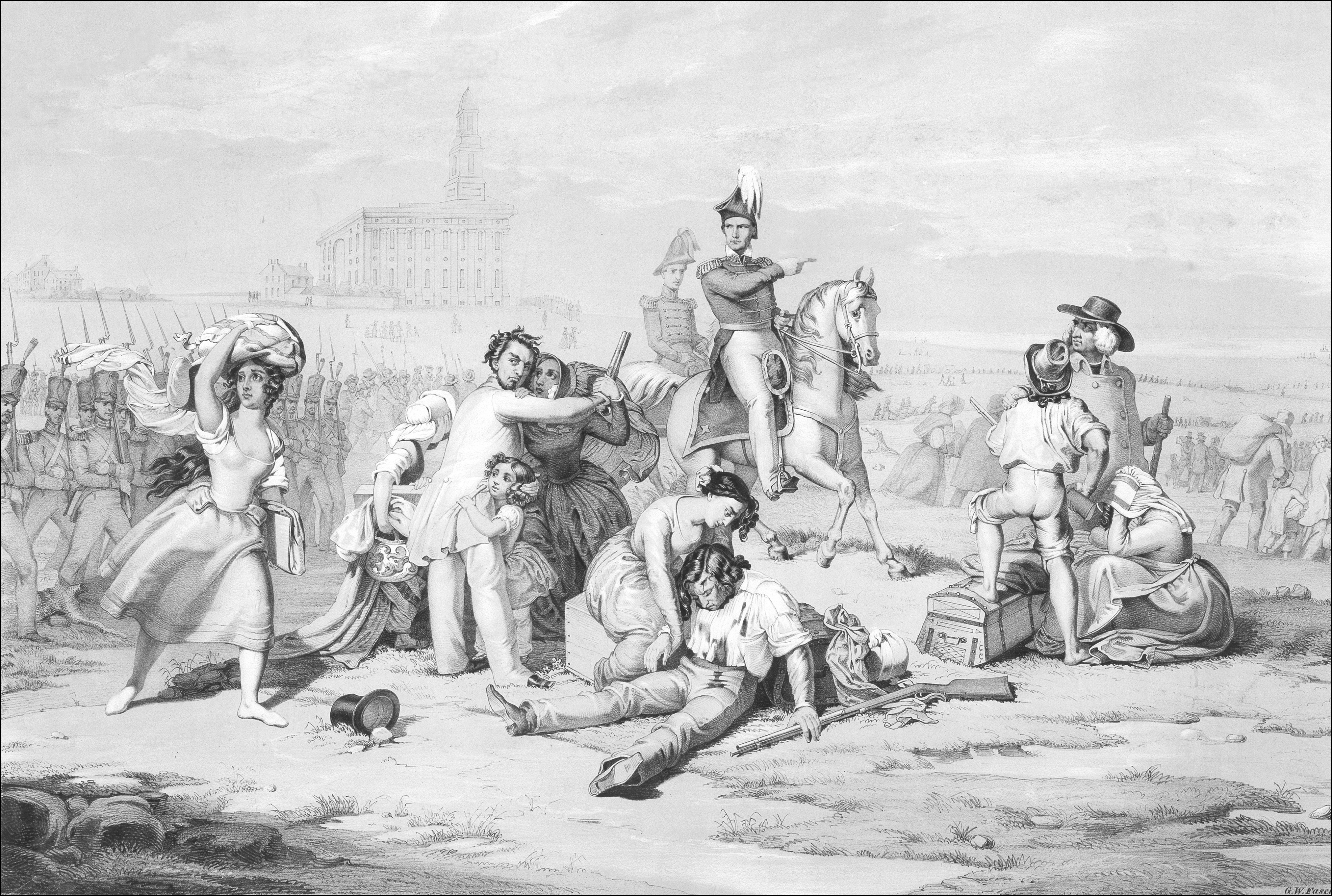
The initial motivation for settlement was not unlike what we have seen in the Shaker movement and in the African American community. Early Saints agreed that America had a special role to play in sacred history. For the Shakers and for the Mormons, Jesus Christ had appeared here. For Mormons the gospel had been restored through Joseph Smith right here. Therefore, the Saints had a religious mandate to build the kingdom in this land, a new Zion. The Mormons were legally enabled, as were African Americans and Shakers, by the extension of federal jurisdiction over western lands. This federal statute allowed for freedom of religion in theory if not in practice. Of course, the Mormons met with fierce resistance from local officials and from popular crowds as they tried to establish themselves successively in New York, Ohio, Missouri, and Illinois. They were pushed westward gradually and eventually began to build Nauvoo, Illinois, in the late 1830s.17
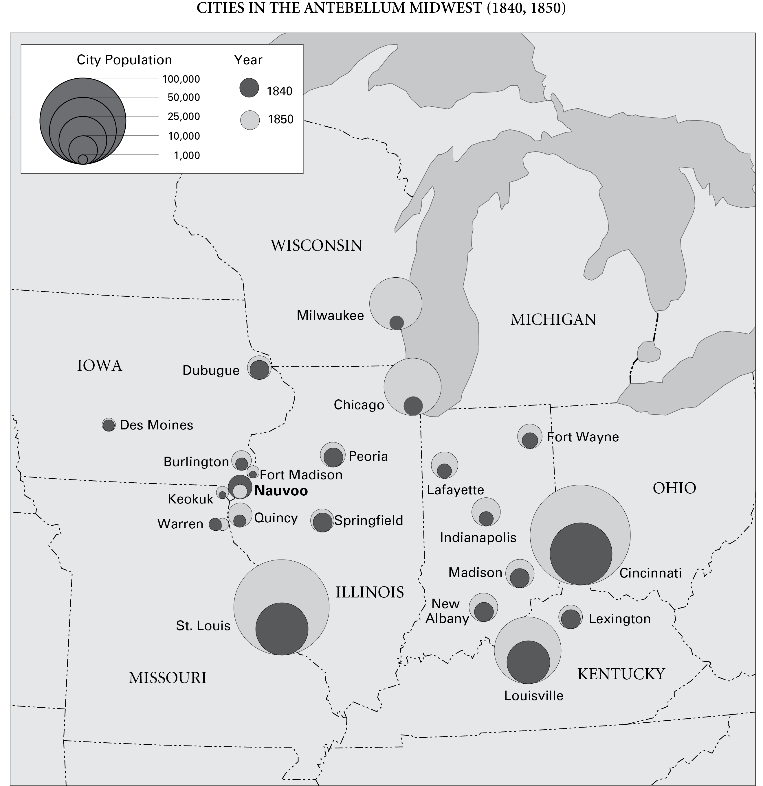
The story of Nauvoo is a story often told. What is perhaps less noted is the extent to which the Mormon presence there helped to develop not just Nauvoo, but also the entire region. From 1840 to 1850, the only community that shrank in size in the Midwest was Nauvoo because of the exodus. Yet at the same time, and primarily because of the development of Nauvoo, this entire region grew dramatically and was affected by the Mormon migration to that area. Even after the bulk of the Mormon community had moved to Utah, the area experienced continued growth. (It would be interesting, in this regard, to study the extent to which Mormons who stayed behind helped to develop those areas, but that’s a subject for another day.)
Persecution and Expulsion of the Mormons from Nauvoo, Illinois, 1846, by G. W. Fasel, 1851, lithograph print, 22" × 28". Courtesy Museum of Church History and Art, Salt Lake City.
This map is based, with permission, on Edwin S. Gaustad and Philip L. Barlow, eds., New Historical Atlas of Religion in America, 3d ed. (New York: Oxford University Press, 2000), 297. Graphics by Kimberly Chen Pace.
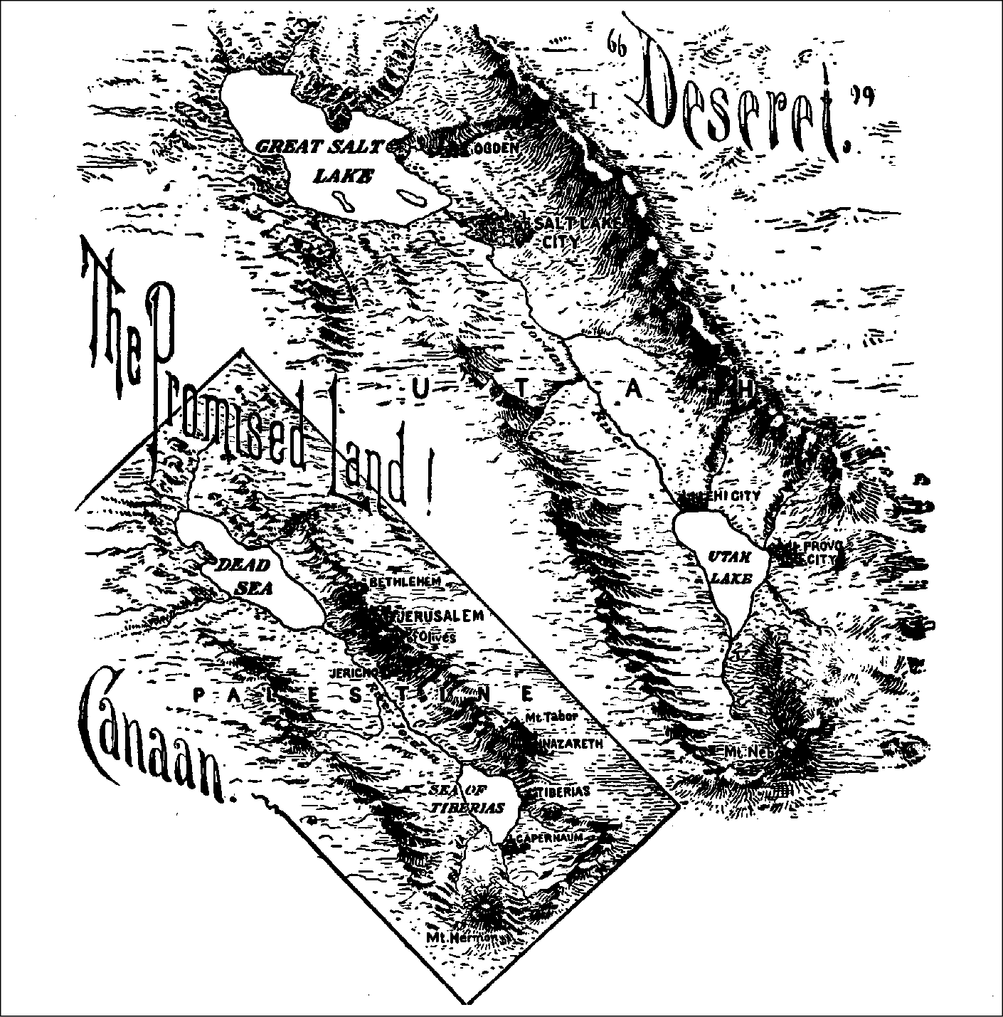
By 1845, after the martyrdom of Joseph Smith, the Saints were once again on the move. This time they traveled under the leadership of Brigham Young, who like Moses would lead the new Israelites into the Zion of the Salt Lake basin. And this time they would find a lasting Zion, a place to build the kingdom of God. As was true for the Shakers, Mormons consecrated all their labor to the church and to God, seeing spiritual fulfillment in the material promise of the western landscape. Just as Kansas was being promoted as a blessed destination for African Americans, so, too, did Mormon Saints gather in Utah to fulfill a religious destiny. Often the dream of land that flowed with milk and honey stood at stark odds with the sod houses or desert spaces. Nonetheless, their religious vision reinforced the connection between a sacred geography and their North American landscape. The Latter-day Saint view of Utah as Zion is reinforced by the often-observed resemblances between the topography of Utah and the topography of Palestine.18
Map depicting the similarities between Utah and Palestine, from William E. Smythe, The Conquest of America, rev. ed. (New York: Macmillan, 1905), facing 54.
In 1849 and 1850, The Church of Jesus Christ of Latter-day Saints proposed the creation of the State of Deseret, which was projected to occupy approximately half of the American West. Although Deseret never came to pass, Mormon settlement of the region nonetheless had marked effects well beyond the Salt Lake Basin. The colony aided in the development of much of the West in strategic and important ways. By the late nineteenth century, Mormons had established interconnected communities throughout the West. What began, then, as a religious protest against the American republic, and a forced march westward, developed into a culture area that continues to define the nation itself.19
Conclusion
What can we conclude from these examples? For one thing, all the movements we have discussed were migrations of American outcasts, people who had been shut out from the ideals of republican freedom. They all held significantly different understandings of what religious freedom could mean, and their very presence reinforces the fact that intolerance still existed in the United States even after the establishment of the nation. In important ways, each group was quite literally denied access to the space of America. Mormons and Shakers were pushed out of New York and later even further west. African Americans fled the South. In other words, space and landscape were never something that could be taken for granted. The land itself came to be seen by these groups as part of God’s providential offering to the faithful. In western areas, all of these groups found a land that fit their religious visions, a Canaan, a Zion, or a millennial kingdom, and they marked the landscape with their sacred names. Even something as simple as the way we have named our towns and the significance and value that we attach to those names reveal the notion that religious dissidents have shaped the nation.20
In each of these cases, the religious visions of communities led Americans to the vast interior of the continent, setting it out not as a place of dark and hidden threats, or a place to be passed over and exited out the other side, but as a living temple. Americans were brought there by dint of these early visionaries, people who never intended to develop the nation, but were in fact fleeing many aspects of the republic. Thus, as one of the unintended consequences of history, religious dissidents shaped that republic in crucial ways.
Notes
1. For more on maps and the ways that they both reflect and construct reality for the viewer, see Jeremy Black, Maps and History: Constructing Images of the Past (New Haven: Yale University Press, 2000); and Mark S. Monmier, How to Lie with Maps, 2d ed. (Chicago: University of Chicago Press, 1996).
2. Definitive treatments of the Second Great Awakening include Robert H. Abzug, Cosmos Crumbling: American Reform and the Religious Imagination (New York: Oxford University Press, 1994); and Nathan Hatch, The Democratization of American Christianity (New Haven: Yale University Press, 1989).
3. On the Puritan ideology of the land, see William Cronon, Changes in the Land: Indians, Colonists, and the Ecology of New England (New York: Hill and Wang, 1984).
4. For more on the Lewis and Clark expeditions, see Stephen Ambrose, Undaunted Courage: Meriwether Lewis, Thomas Jefferson, and the Opening of the American West (New York: Simon and Shuster, 1996).
5. Arrowsmith was one of the founders of the Royal Geographical Society. See E. H. Brown, ed. Geography Yesterday and Tomorrow (New York: Oxford University Press, 1987).
6. Anders Stephanson, Manifest Destiny: American Expansionism and the Empire of Right (New York: Hill and Wang, 1996). For a classic, but much older, exploration of this theme, see Frederick Merk, Manifest Destiny and Mission in American History: A Reinterpretation (1963; reprint ed., Cambridge: Harvard University Press, 1995).
7. I am indebted to Jan Shipps for the metaphor of the donut, which she has used to describe the failure of many American historians to take seriously the history of the Mormon empire in Utah.
8. See Arch C. Gerlach, ed. The National Atlas of the United States of America (Washington, D.C.: U.S. Department of the Interior, Geological Survey, 1970), 136. This image may be viewd online at www.lib.utexas.edu/maps/united_states/exploration_1800.jpg.
9. On early Protestant missionary efforts in the Pacific, see Arrell Morgan Gibson and John S. Whitehead, Yankees in Paradise: The Pacific Basin Frontier (Albuquerque: University of New Mexico Press, 1993); and Tom Hiney, On the Missionary Trail: A Journey through Polynesia, Asia and Africa with the London Missionary Society (New York: Grove Press, 2001). On Methodists in Oregon, see Robert J. Loewenberg, Equality on the Oregon Frontier: Jason Lee and the Methodist Mission, 1834–43 (Seattle: University of Washington Press, 1976).
10. See Bret E. Carroll, The Routledge Historical Atlas of Religion in America (New York: Routledge, 2001), 69.
11. For more information on the international scope of U.S. missions in this period, see William R. Hutchison, Errand to the World: American Protestant Thought and Foreign Missions (Chicago: University of Chicago Press, 1987).
12. Stephen J. Stein, The Shaker Experience in America: A History of the United Society of Believers (New Haven: Yale University Press, 1994).
14. On the Exodus theme, see Eddie S. Glaude Jr., Exodus! Religion, Race, and Nation in Early Nineteenth Century Black America (Chicago: University of Chicago Press, 2000); and Albert J. Raboteau, “African-Americans, Exodus, and the American Israel,” in Fire in the Bones: Reflections on African-American Religious History (Boston: Beacon Press, 1995): 17–36.
15. For more on the “exoduster” movement of African Americans, see Nell Irvin Painter, Exodusters: Black Migration to Kansas after Reconstruction (New York: Knopf, 1976).
17. The story of Mormon movement westward is better documented than that of other religious groups. Still the most comprehensive study of the building of Zion in Utah is Leonard J. Arrington, Great Basin Kingdom: An Economic History of the Latter-day Saints, 1830–1900 (Cambridge: Harvard University Press, 1958). For a more contemporary set of interpretations, see Thomas G. Alexander, ed., Great Basin Kingdom Revisited: Contemporary Perspectives (Logan: Utah State University Press, 1991).
18. For a scale comparision of Utah and Palestine, see Edwin S. Gaustad and Philip L. Barlow, eds., New Historical Atlas of Religion in America, 3d ed. (New York: Oxford University Press, 2000), 301.
19. For the extent to which Mormons currently reside in the western United States, see New Historical Atlas, 307; and Carroll, Routledge Historical Atlas, 82–83.
20. For a sampling of place names with religious significance in the United States, see New Historical Atlas, 336–39.